Australian Weather
National Summary
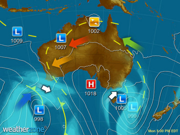
A monsoon though over northern WA, the Top End and northern QLD is generating area of heavy rain, showers and storms. Low pressure troughs are triggering showers and storms over the southeast. North-westerly winds ahead of a trough are dragging a very hot airmass over NSW.
State Weather
Click for state forecasts


National Synoptic
Weather News
'Monsoon burst' causes havoc on Darwin roads, minor flooding
13:00 EDT
It has been a wet 24 hours in Darwin, with a dumping more than 200 millimetres of rain over the city, causing havoc on the roads.
Darwin gets soaked within monsoon trough
11:34 EDT
An active monsoon trough continues to intersect the northern Kimberley and Top End, leading to thunderstorms and heavy rainfall over large parts of northern Australia, including Darwin.
Sydney weather: City sizzles with mercury expected to pass 40C in some areas
11:30 EDT
Sydney's sweaty summer is expected to continue on Sunday with the mercury tipped to pass 40 degrees Celsius in parts of the city.


Extremes and Records
| Current Extremes | Last 3 Days Extremes | Extremes This Month | |||
|---|---|---|---|---|---|
| Thu 02/02 | Fri 03/02 | Sat 04/02 | |||
|
43.1°C Wilcannia Ap, NSW/ACT |
Hottest |
45.4°C Mungindi, NSW/ACT |
46.2°C Birdsville Ap, Qld |
45.0°C Wanaaring, NSW/ACT |
46.2°C Birdsville Ap, Qld |
|
8.4°C Mt Read, Tas |
Coldest |
2.0°C Thredbo Village, NSW/ACT |
5.1°C Thredbo Village, NSW/ACT |
6.0°C Mt Wellington, Tas |
-0.6°C Liawenee, Tas |
|
NW 48km/h Mt Gellibrand, Vic |
Windiest |
112km/h Maatsuyker Is, Tas |
101km/h Maatsuyker Is, Tas |
101km/h Maatsuyker Is, Tas |
- |
|
19.2mm last hr Cocos Island Ap, WA |
Wettest |
81.8mm Centre Island, NT |
110.6mm White Cliff Point, Qld |
203.0mm Noonamah, NT |
202.8mm Noonamah, NT |
| Australia's Records for February | |||
|---|---|---|---|
| Max | Min | Rain | |
| Highest 50.5°C at Mardie, WA in 1998 Lowest -2.7°C at Mt Wellington, Tas in 1994 |
Highest 35.0°C at Moomba Ap, SA in 2004 Lowest -7.4°C at Mt Wellington, Tas in 1994 |
Highest 907.0mm at Crohamhurst, Qld in 1893 |
|
-
Display your Local Weather here
automatically each time you visit us:

Rotates through Temperature,
Wind, Humidity and RainUse the Search Bar above
to find your Local, and go to the Local page
Click "Set My Local"
button next to the location name


