Sydneysiders who tossed and turned their way through yet another stifling night can rest assured: relief is on its way on Monday afternoon.
A southerly change is expected to hit the city between 4pm and 5pm, and in the west about an hour later, dropping the temperature considerably and marking the start of a few milder days.
More Victoria News Videos
Sydney's hottest nights on record
Sleepless in Sydney with two nights recording a minimum of 26 degrees Celsius.
Nights, though, will remain at least 3 degrees above average for February.
Before then, another hot day is under way. The mercury reached 33.8 degrees in the city as south-easterly breezes moderated temperatures but western regions such as Penrith had already reached 37 degrees soon after noon.
"If the winds stay light there's a risk the temperatures could go up a couple of degrees," Zach Porter, a duty forecaster with the Bureau of Meteorology, said.
If they do, the city could break the record for the most days above 35 degrees in a season. The previous record was nine days over 35 degrees, set in the summer of 1895-96 and matched last week on January 31.
The cool change should knock the mercury down to the mid-20s but conditions will remain humid and overnight temperatures will most likely remain in the low-20s, Mr Porter said.
"It's still going to feel warm ... but not as uncomfortable as the last couple of days," he said.

Oppressive nights
That forecast will be welcomed after overnight temperature in the city dropped to a low of only 26.2 degrees just before 4am - but at that time it felt much warmer, at 29.6 degrees, the bureau said.
Just 30 minutes later, it was already 29.1 degrees in the city, but felt as if it was over 30.

Penrith was still sitting at 28.2 degrees at midnight, but it felt like 32.5 degrees, before dropping to a low of 23.9 degrees just after 6am.
Weatherzone meteorologist Graeme Brittain said the cool change would bring the potential for heavy rain and thunderstorms in coming days.
"There is going to be a gusty southerly change, bringing some strong winds to the coast and also a relief in the heat as well, firstly towards to the east but then propagating through to the western suburbs probably about an hour later," he said.
"Tuesday and Wednesday, the maximum temperature will be in the mid to high 20s, so that is quite a significant drop in temperature. It will be welcome relief, but with that there is going to be a lot of rain around on Tuesday.
"We're looking at extensive and persistent rain as well as thunderstorms, probably amounting to 20-30 millimetres quite widely across Sydney and then localised falls in excess of 50 millimetres possible."
The bureau is not tipping as much rain, with only a chance of showers and storms ahead of the cool change. More persistent showers and rain on Tuesday could bring 3-10 millimetres, with a similar range on Wednesday.
Still, any rainfall will be popular among gardeners. Last month's water use was Sydney's highest for any month since January 2003, a spokesman for Sydney Water said.
Sunday maintained the recent surge in water use, too. Demand reached 2.215 billion litres and exceeded the 14-year peak demand in usage recorded only six days earlier, he said.
Lingering heat
Mr Brittain said a low-pressure trough north of NSW had allowed the heat to build up and linger.
"It has drawn the heat down from the interior, but also we've got warm sea surface temperatures off the coast and, with sea breezes, this allows moisture to push inland over coastal parts and this made it feel a few degrees warmer than the actual temperature.
A chart of current sea-surface anomalies shows a region of unusually warm temperatures off the NSW coast near Sydney. (See chart below.)

"The combination of hot air mass coming from the interior meeting moister air towards the coast has made it feel very uncomfortable during the night and not allowed the temperatures to drop away," Mr Brittain said.
"That's why we've seen the temperatures a lot of nights so far this year not dropping below the low to mid 20s and feeling into the high 20s quite a number of nights."
According to Beachwatch, sea-surface temperatures measured off Sydney are about 24 degrees.
Inland bakes
While coastal populations along eastern Australia are in for another warm week, spare a thought for those living in regional areas, many of whom are in the midst of record-breaking heat.
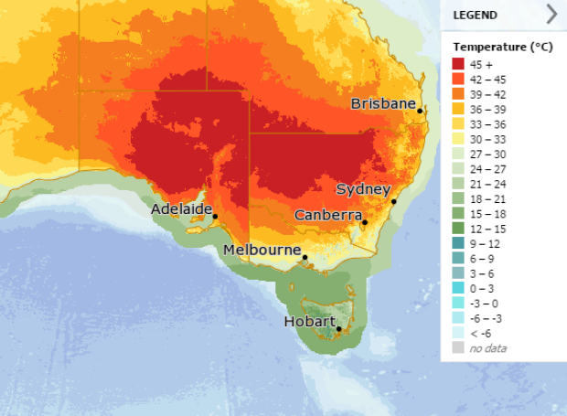
Towns such as Bourke in north-west NSW are expected to face days of temperatures in the low- to mid-40s before the mercury nudges 47 degrees on both Saturday and Sunday.
Bourke had already reached 41 degrees by soon after midday, making it the hottest place in NSW.
Of the coming days, the largest region expected to reach or exceed 45 degrees will be on Saturday. (See bureau chart below.)

On current forecasts, Sydney's maximums will climb back into the 30s from Thursday, with 36 degrees tipped for Sunday. For western suburbs such as Penrith, Friday to Sunday will bring more days of 40 degrees, the bureau said.
Weatherzone is owned by Fairfax Media, publisher of this website.


