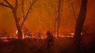
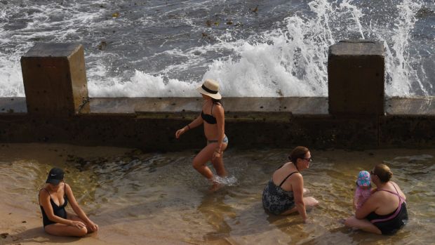
Sydneysiders sweltered through another belter on Sunday, with temperatures soaring above 40 degrees across much of the city.
Temperatures in the city reached 34.9 degrees at 12.40pm at Observatory Hill on Sunday, falling just shy of setting a new record of 10 days above 35 degrees in a season.
More Environment News Videos

- Video duration
- 00:24
How to stay cool in a heatwave
How to stay cool in a heatwave
Sydney-siders share their tips for dealing with the record temperatures.
Up Next
Fire and storms with Nick Moir and Wolter Peters

- Video duration
- 20:57
- Video duration
- 20:57
Fire and storms with Nick Moir and Wolter ...
Fire and storms with Nick Moir and Wolter Peters
The photographers discuss a selection of images from their storied careers chasing storms, fires and getting amongst the thick of some very dangerous weather conditions. Imparting some valuable tips and tricks as they do so.
Up Next
Weather seminar highlights with Nick Moir

- Video duration
- 02:24

- Video duration
- 02:24
Weather seminar highlights with Nick Moir
Weather seminar highlights with Nick Moir
The photographer discusses a selection of images from his storied career chasing storms, fires and getting amongst the thick of some very dangerous weather conditions.
Up Next
Giant lava stream explodes into sea in Hawaii

- Video duration
- 01:07

- Video duration
- 01:07
Giant lava stream explodes into sea in ...
Giant lava stream explodes into sea in Hawaii
A dramatic and dangerous stream of lava from Kilauea Volcano is pouring out of a sea cliff on Hawaii Island, splashing into the Pacific Ocean below and exploding upon impact.
Up Next
'Clean coal' makes a comeback

- Video duration
- 01:24

- Video duration
- 01:24
'Clean coal' makes a comeback
'Clean coal' makes a comeback
New technology means coal will play a role in electricity generation long into the future, says Malcolm Turnbull. Courtesy ABC News 24.
Up Next
'Fire hose' of lava pours into ocean

- Video duration
- 01:02

- Video duration
- 01:02
'Fire hose' of lava pours into ocean
'Fire hose' of lava pours into ocean
The United States Geological Survey has released stunning footage of a "fire hose" of lava pouring into the ocean at Kamokuna in the Hawaii Volcanoes National Park.
Up Next
Heatwave, fire ban as students return to school

- Video duration
- 01:28

- Video duration
- 01:28
Heatwave, fire ban as students return to ...
Heatwave, fire ban as students return to school
Students face an uncomfortable start to the school year as hot and dry conditions will persist this week, according to Weatherzone senior meteorologist Rob Sharpe.
Up Next
Kurri Kurri bushfire downgraded

- Video duration
- 02:05

- Video duration
- 02:05
Kurri Kurri bushfire downgraded
Kurri Kurri bushfire downgraded
A 26-year-old man is being questioned by police as firefighters contain the bushfire in Kurri Kurri.
How to stay cool in a heatwave
Sydney-siders share their tips for dealing with the record temperatures.
With 35 degrees tipped for Monday, the city has another shot at breaking a record that has stood since the summer of 1895-96.
Weather stations at Sydney Olympic Park, Camden, Richmond, Holsworthy and Canterbury all recorded temperatures surpassing 40 degrees on Sunday afternoon. Bankstown's 42.7 degrees was the city's hottest.
Related Content


Joel Pippard, a meteorologist at Weatherzone, said the heat would most likely remain in the high 30s across the city throughout the afternoon with the maximum predicted temperature "possible throughout the day until about 6pm".
"A slight sea breeze is going to be switching on and off all day, so that maximum temperature should never come and stay," Mr Pippard said.
But the heat would most likely peak about 3pm, before starting to cool off after 6pm, Mr Pippard said.
A slight chance of rain and thunderstorms across the city and particularly out west is possible in the late afternoon, and is likely to hit "before any kind of cooling starts" in the early evening.
"The current record of nine days was made in 1896," Mr Pippard said.
"We've already equalled that record of nine days this summer."

Overnight, the temperature should drop to 25 degrees but will most likely remain in the high 20s until about midnight, Mr Pippard said.
The heat will continue on Monday with a top of 35 degrees predicted in the city and 41 in Penrith, although a "cooler breeze" should provide some relief throughout the day.
The temperatures will finally cool down with a strong southerly change late on Monday afternoon, Mr Pippard said.
The milder conditions will most likely continue on Tuesday and Wednesday with possible showers, before picking up again on Thursday, the Bureau of Meteorology forecast.
A return to uncomfortable conditions late in the week is set to be more pronounced in the west, with the temperature expected once again to climb into the 40s by Saturday.
Weatherzone is owned by Fairfax Media, publisher of this website.