
National Synoptic Information
A Synoptic chart is any map or chart that depicts meterological or atmospheric conditions over a larger area at any given time. The charts on this page are drawn from information supplied by Weatherzone.
A Synoptic chart is any map or chart that depicts meterological or atmospheric conditions over a larger area at any given time. The charts on this page are drawn from information supplied by Weatherzone.
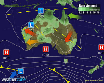
Low pressure troughs will maintain heat, high humidity, showers and storms over much of northern and central Australia and into WA and northern NSW. A high should keep much of VIC, southern SA and southern WA dry. Cool westerlies should bring showers to TAS.

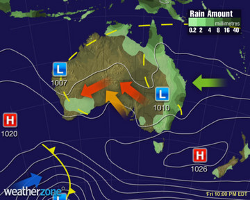
A deepening monsoonal trough should bring heavy showers and storms to the north. A series of low pressure troughs will continue to bring warm to very hot weather to WA, SA, VIC and NSW, along with showers and storms. Showers will ease on western coast of TAS.

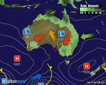
A trough will move into western SA, drawing heat throughout southeastern states. This trough and the one lingering over NSW will producing showers and storms. An active monsoon will bring rain and storms over the tropics. Low pressure will continue to trigger storms in WA.

A deep low pressure trough will spread from northwestern WA to the southeast, bringing rain and storms, whilst directing heat across northern and eastern VIC and NSW and southern QLD. An active monsoon trough will bring rain and storms to the tropics.
A monsoon trough and low will continue to deepen and bring rain and storms to the tropics. A low pressure trough stretching from the northwest to NSW will produce patchy rain, showers and storms, whilst heat lingers along the trough and to its north.
A tropical cyclone may form within the rain-bearing monsoon trough that will extend across northern WA and northern NT. A broad low pressure trough extending from central Australira to NSW will produce patchy rain, showers and storms, whilst heat lingers, mainly inland.
A tropical cyclone may form within the rain-bearing monsoon trough that will extend across northern WA and northern NT. A broad low pressure trough extending from central Australira to NSW will produce patchy rain, showers and storms, whilst heat lingers, mainly inland.


