

@BOM_WAさんをブロックしました
このツイートを表示してもよろしいですか?これによって@BOM_WAさんのブロックが解除されることはありません。
-
A windy night for
#Perth with a number of sites recording strong wind gusts, including a gust of 93 km/h at Perth Airport. The risk of severe wind gusts has now abated, but keep your trampolines tied down as gusty winds are expected to develop again this evening.pic.twitter.com/aw9M7IpXlw 今後は興味のあるツイートがもっと表示されるようになります。 取り消す取り消す
 -
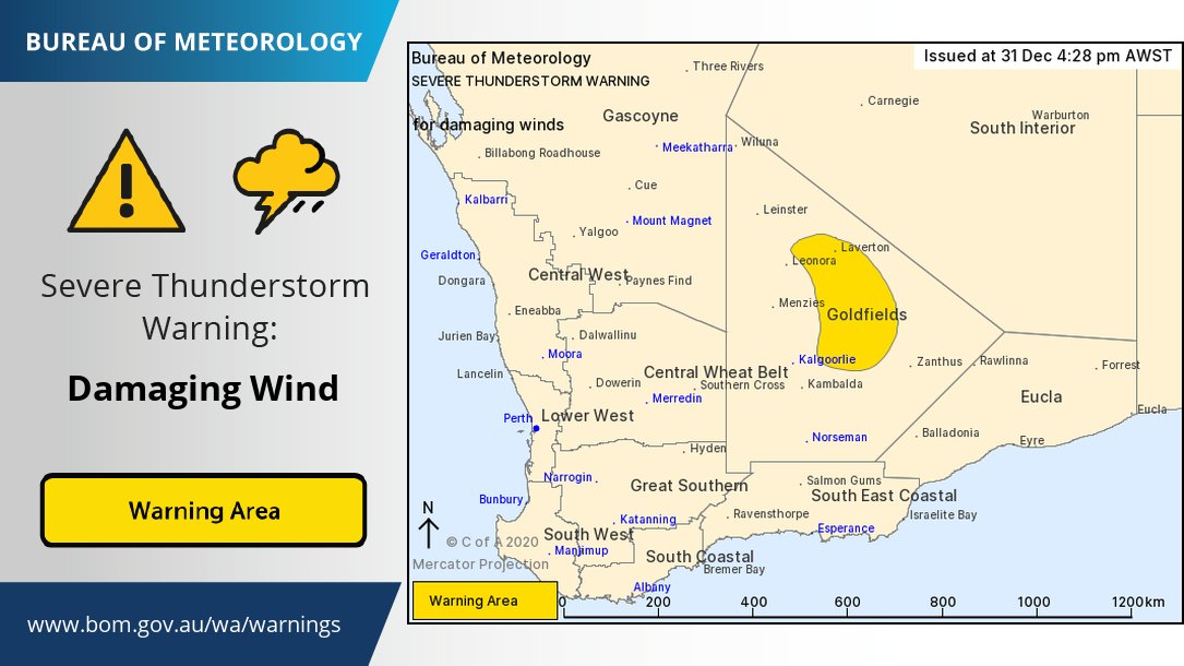
A slow moving line of thunderstorms over the Central Wheat Belt may result in heavy rain over the next few hours. A Severe Thunderstorm Warning has been issued; for more details go to http://ow.ly/hRXf50CY9Q4 pic.twitter.com/z9d7NuFSSl
 今後は興味のあるツイートがもっと表示されるようになります。 取り消す取り消す
 -
There is a risk of damaging easterly winds about the hills over the Lower West and northern South West districts overnight Friday and into Saturday morning. Gusts may reach up to 100 km/h. Refer to latest warning here: http://ow.ly/9bWZ50CXUEb pic.twitter.com/cA6PBiUWF4
 今後は興味のあるツイートがもっと表示されるようになります。 取り消す取り消す
 -
A line of severe thunderstorms is moving through the Goldfields. Leonora Airport recorded a wind gust of 113 km/h at 4:14pm. Check the latest warning at http://ow.ly/EMm850CXqV0 pic.twitter.com/JUTqIm7JEj
 今後は興味のあるツイートがもっと表示されるようになります。 取り消す取り消す
 -
If you're out celebrating New Year's Eve tonight, the good news is that most of the State will be clear of rain at midnight, with only a few storms lingering over northern inland parts and near the eastern south coast. Have a Happy New Year!pic.twitter.com/UbmGqwB46R
 今後は興味のあるツイートがもっと表示されるようになります。 取り消す取り消す
 -
A trough near the west coast will bring a hot air mass southwards, increasing temperatures over the SW on Tuesday and Wednesday. Combined with gusty winds this will increase the fire danger ratings. Keep up to date with forecasts and warnings at http://ow.ly/73rb50CVcJg pic.twitter.com/x4pdwmwsb4
今後は興味のあるツイートがもっと表示されるようになります。 取り消す取り消す -
Coastal suburbs of Perth missed the memo that today was the hottest Christmas Day in Perth since 2007. Perth hit a scorching high of 40.4°C at 1.56pm whilst Swanbourne had a very pleasant maximum of 29.8°C at 11.13am. What a difference 11 kilometres makes!pic.twitter.com/kfH2gY6a1d
 今後は興味のあるツイートがもっと表示されるようになります。 取り消す取り消す
 -
Significant early wet season flows in the
#FitzroyRiver in the#Kimberley. In the past three days alone, more than 480 billion litres has flowed past Fitzroy Crossing, enough to fill#WindjanaGorge about 30 times over. For the latest forecasts visit - http://ow.ly/nctU50CTH5v pic.twitter.com/MClOISPKSi 今後は興味のあるツイートがもっと表示されるようになります。 取り消す取り消す
 -
After a busy start to the tropical season with some lows and plenty of rain in the Kimberley and Pilbara we are not expecting any cyclones between Christmas and New Year's. Clear skies tonight apart from in the Kimberley and far SW corner. Forecasts here http://ow.ly/vosu50CTHcm pic.twitter.com/PmjOuC08l8
 今後は興味のあるツイートがもっと表示されるようになります。 取り消す取り消す
 -
After only reaching 21.3°C in Halls Creek & 21.9°C in Rabbit Flat yesterday both towns near the WA/NT border broke the records (122 years) and (52 years respectively) for lowest ever December max temps. The tropical low now near Kununurra brought rain and cooler conditions.pic.twitter.com/cUPh2PFMnZ
 今後は興味のあるツイートがもっと表示されるようになります。 取り消す取り消す
 -
A low to severe intensity heatwave is affecting
#Perth, the south west and the Gascoyne coast, with inland parts expected to be a few degrees hotter than places closer to the coast. See which areas are affected here http://ow.ly/7qVf50CSKq5 pic.twitter.com/bspDsvZXue今後は興味のあるツイートがもっと表示されるようになります。 取り消す取り消す -
#Perth, the south west and the Gascoyne coast will be hotter than normal as a low intensity heatwave sets in. Hotter temps can increase fire danger. Stay safe and try to stay cool@dfes_wa@WAHealth Forecasts here http://ow.ly/eGFv50CRLZw Heatwave info http://www.bom.gov.au/australia/heatwave/ …pic.twitter.com/vc0qPVdzg9
 今後は興味のあるツイートがもっと表示されるようになります。 取り消す取り消す
 -
#LaNina is approaching its peak, the#SouthernAnnularMode is strongly positive, while the#MaddenJulianOscillation is weak—learn how these climate drivers are influencing Australia's weather right now in our Climate Driver Update: http://ow.ly/NuDn50CRKmu pic.twitter.com/9EoOuhI2Ip 今後は興味のあるツイートがもっと表示されるようになります。 取り消す取り消す
 -
A tropical low has brough heavy rainfall to the
#Kimberley resulting in widespread river rises throughout the area. The low is now shifting south east and rainfall is rapidly contracting eastwards towards the Territory. For the very latest visit http://ow.ly/pvzo50CRK7K pic.twitter.com/42jd6nkpjS 今後は興味のあるツイートがもっと表示されるようになります。 取り消す取り消す
 -
Heating up over the next few days in
#Perth with max temps close to 40C on Wed and Thurs. Xmas day now expected to be near 35C. Latest forecast here: http://ow.ly/M41O50CQKNH pic.twitter.com/OWx2rvIXi0 今後は興味のあるツイートがもっと表示されるようになります。 取り消す取り消す
 -
There have already been large rainfall totals observed across the
#Kimberley due to a tropical low over the region. Further heavy falls are expected today and tomorrow before conditions begin to ease later in the week. Latest warnings http://ow.ly/EqRn50CQGfd pic.twitter.com/0Lpr25qNxv今後は興味のあるツイートがもっと表示されるようになります。 取り消す取り消す -
Heavy rainfall across the
#Kimberley is leading to river level rises, including this 7m increase in 24hrs at Mount Joseph! Severe Weather and Flood Warnings remain in place http://ow.ly/ewru50CQEjO pic.twitter.com/ikEsoljuKa 今後は興味のあるツイートがもっと表示されるようになります。 取り消す取り消す
 -
After a dry few years, rain finally returned to the
#Ord. Recent lows have brought the wettest start to the wet season in#Kununurra in >10 years. Rivers are responding with some inflows to#Lake Argyle already and more expected this week. See warnings http://ow.ly/yKL350CQhA6 pic.twitter.com/VmoUdcLAOu 今後は興味のあるツイートがもっと表示されるようになります。 取り消す取り消す
 -
A line of thunderstorms moving over
#Lombadina has produced 91mm in 1 hour between 11:20am and 12:20pm WST. Rainfall rates this heavy are not very common and may produce flash flooding. A severe weather warning is current at http://ow.ly/E2Mc50CQgRs@dfes_wapic.twitter.com/oKN2mh6kaT今後は興味のあるツイートがもっと表示されるようになります。 取り消す取り消す -
The tropical low over the west Kimberley has produced some large rainfall. Falls of 50-100mm in the east and NW coast and 25-50mm elsewhere in the Kimberley. Heavy rainfall and squally winds will continue today and tomorrow over the Kimberley. Warnings at http://ow.ly/gs2f50CQfbs pic.twitter.com/bKm9cfaXQa

 今後は興味のあるツイートがもっと表示されるようになります。 取り消す取り消す


読み込みに時間がかかっているようです。
Twitterの処理能力の限界を超えているか、一時的な不具合が発生しています。やりなおすか、Twitterステータスで詳細をご確認ください。