

Tweety
- Tweety, bieżąca strona.
- Tweety i odpowiedzi
- Multimedia
Zablokowano @BOM_WA
Czy na pewno chcesz zobaczyć te Tweety? Zobaczenie Tweetów nie odblokuje @BOM_WA
-
Lots of tropical activity currently in the Australian region.
#CycloneKimi & a tropical low north of the Top End on the sat image. Low may reach tropical cyclone intensity later this week, possibly crossing#Pilbara coast by end of the week. http://ow.ly/sHDX50Db0CH pic.twitter.com/0MEu3QTdYq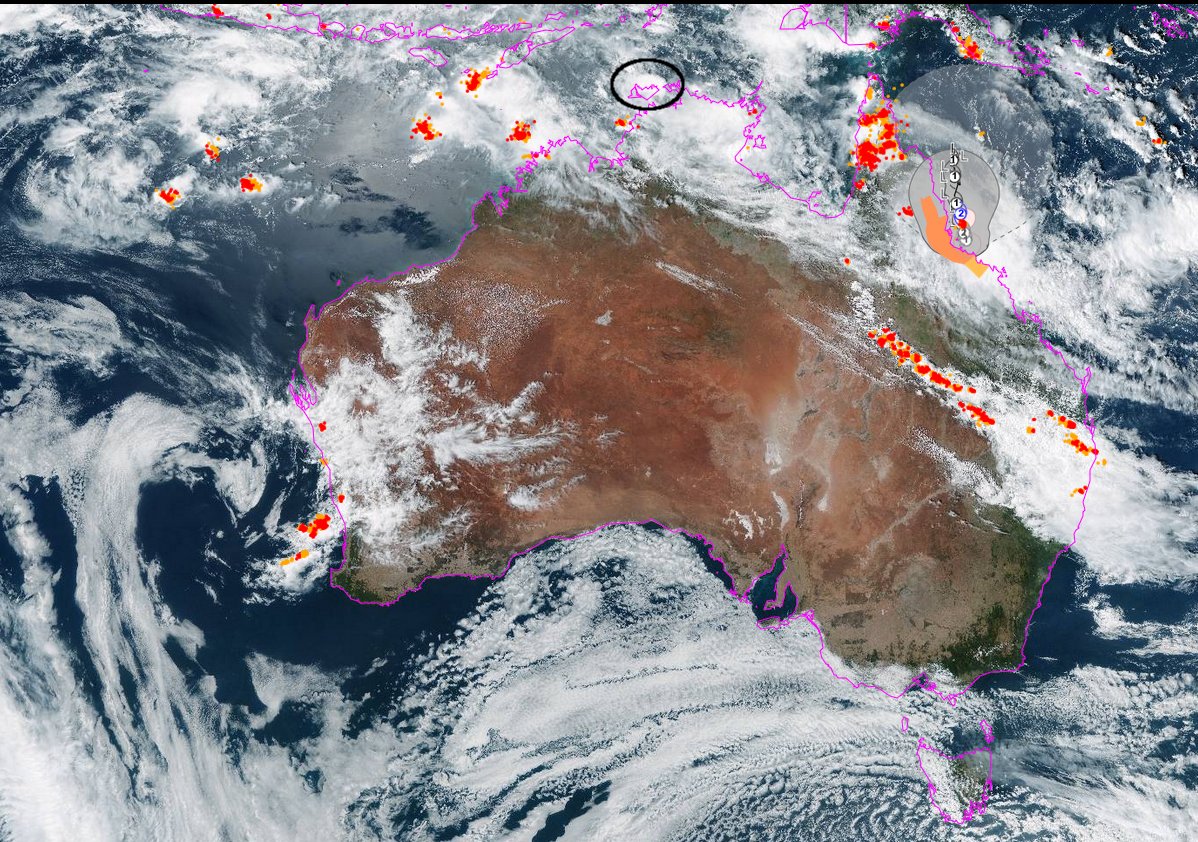 Dziękujemy. Twitter skorzysta z tych informacji, aby Twoja oś czasu bardziej Ci odpowiadała. CofnijCofnij
 -
Seeing high based showers & possible thunderstorms moving down from the N on
#Perth radar. Not expected to bring much rain as air is very dry underneath cloud so rain evaporates before it hits the ground. (virga) A risk of lightning though, so report any fires to@dfes_wapic.twitter.com/KwxeKWObzPDziękujemy. Twitter skorzysta z tych informacji, aby Twoja oś czasu bardziej Ci odpowiadała. CofnijCofnij -
Tropical Cyclone Joshua has formed over the central Indian Ocean and is tracking to the west southwest over open waters away from the Cocos(Keeling) Islands.
#CycloneJoshua http://www.bom.gov.au/cyclone pic.twitter.com/gYgJ3xAwqH Dziękujemy. Twitter skorzysta z tych informacji, aby Twoja oś czasu bardziej Ci odpowiadała. CofnijCofnij
 -

 Temperatures in January and the summer so far have been the highest on record in coastal parts of the Kimberley and Pilbara and very much above average in Perth and coastal regions along the west coast. More heat to come. See latest forecasts here http://ow.ly/t3h850D97B3 pic.twitter.com/3XQsCWPZIgDziękujemy. Twitter skorzysta z tych informacji, aby Twoja oś czasu bardziej Ci odpowiadała. CofnijCofnij
 -
A tropical low over the central Indian Ocean may develop into a tropical cyclone during Saturday morning. It is not expected to impact the west Australian mainland. http://www.bom.gov.au/cyclone pic.twitter.com/Jcl9LdUTCo
 Dziękujemy. Twitter skorzysta z tych informacji, aby Twoja oś czasu bardziej Ci odpowiadała. CofnijCofnij
 -
A severe weather warning for damaging easterly winds about the
#DarlingScarp and the foothills in the Lower West district has been issued. See all the details at http://ow.ly/nweo50D89YN pic.twitter.com/zNKrlcZRyt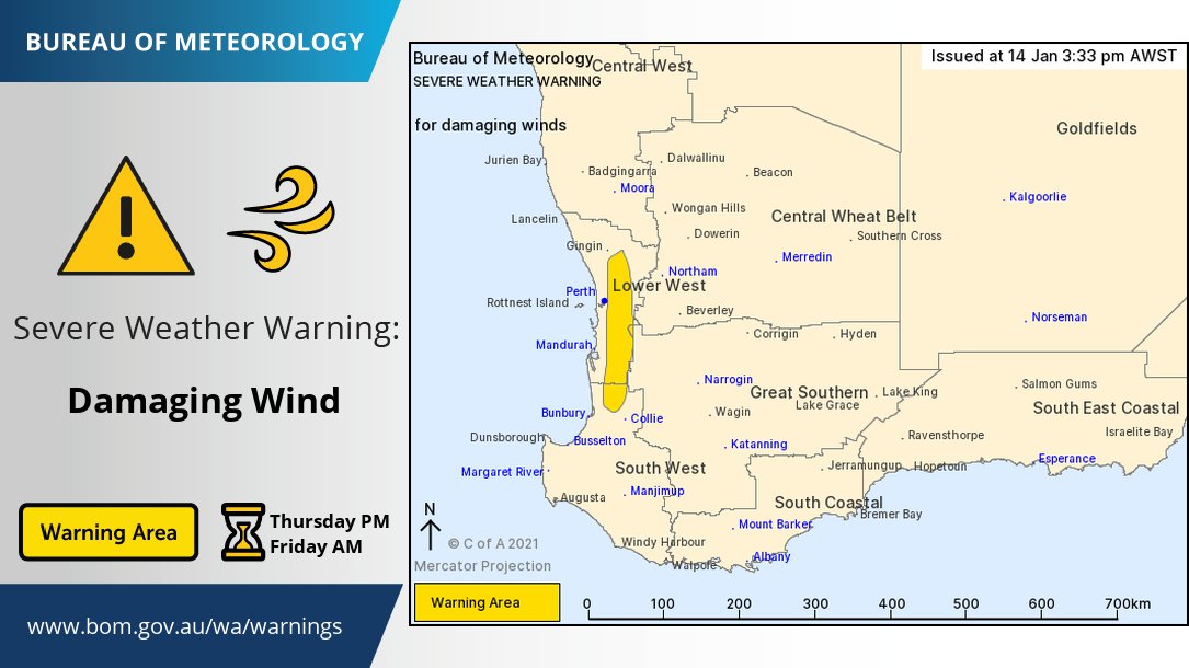 Dziękujemy. Twitter skorzysta z tych informacji, aby Twoja oś czasu bardziej Ci odpowiadała. CofnijCofnij
 -
Today marks the second time the sea breeze stays away from Perth metro after an already unusual 5 day absence earlier this month. It's expected to stay away another 5 days, returning Monday. Strong easterlies are the culprit again. Wind forecasts here http://ow.ly/ZzC150D86Ea pic.twitter.com/wnpoGoeZco
 Dziękujemy. Twitter skorzysta z tych informacji, aby Twoja oś czasu bardziej Ci odpowiadała. CofnijCofnij
 -
Oppressively hot and humid conditions are continuing in
#Broome and#PortHedland with overnight humidity reaching 91% in Port Hedland. Dew points, a more precise marker of how muggy it feels, are also extremely high http://media.bom.gov.au/social/blog/1324/feeling-hot-and-bothered-its-not-the-humidity-its-the-dew-point/ …pic.twitter.com/nerD7myByn Dziękujemy. Twitter skorzysta z tych informacji, aby Twoja oś czasu bardziej Ci odpowiadała. CofnijCofnij
 -
A Severe Weather Warning for damaging wind has been issued, with another night of strong and gusty easterly winds about the
#DarlingScarp and foothills ahead. Keep up to date at http://ow.ly/xwqP50D70Xm .@dfes_wapic.twitter.com/LNGgMk4mAo Dziękujemy. Twitter skorzysta z tych informacji, aby Twoja oś czasu bardziej Ci odpowiadała. CofnijCofnij
 -
Broome has had it's hottest start to the year, with hot days (in maroon) and hot nights (in orange) well above the average (dotted lines). The heat and humidity is here to stay for the next week, with possible storms from Friday http://ow.ly/ryf750D61FN pic.twitter.com/WppJbMCiZO
 Dziękujemy. Twitter skorzysta z tych informacji, aby Twoja oś czasu bardziej Ci odpowiadała. CofnijCofnij
 -
Bureau of Meteorology, Western Australia podał/a dalej
From
#drought &
#fire to
#LaNina: understand Australia's climate in 2020 with our#AnnualClimateStatement. Learn more in our blog: http://ow.ly/lHAT50D4QEp pic.twitter.com/7fsj4DMDGb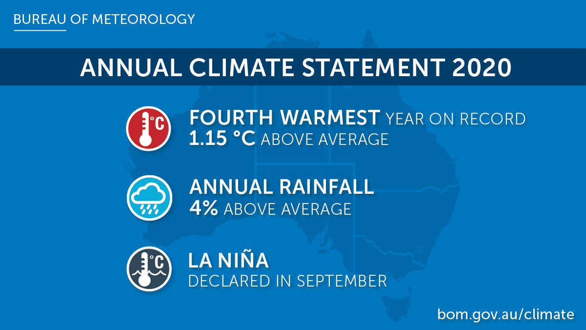 Dziękujemy. Twitter skorzysta z tych informacji, aby Twoja oś czasu bardziej Ci odpowiadała. CofnijCofnij
 -
The hottest ever January overnight temp in Broome was 30.5°C. Apart from cooling thunderstorms late last week so far this month Broome has had 2 nights of 30°C or above, with more uncomfortably hot and humid nights of 29°C to come http://ow.ly/6D7R50D4Qi8 http://www.bom.gov.au/australia/heatwave/ …pic.twitter.com/P9RjdTfl5D

 Dziękujemy. Twitter skorzysta z tych informacji, aby Twoja oś czasu bardziej Ci odpowiadała. CofnijCofnij
 -
 Strong easterlies returning to the South West Land Division from Thursday from a high pressure ridge developing along the south coast. Good weather for flies
  https://www.uwa.edu.au/news/article/2021/january/why-flies-are-particularly-annoying-this-summer … What is a sub-tropical ridge? Info here http://www.bom.gov.au/watl/about-weather-and-climate/australian-climate-influences.shtml …pic.twitter.com/BDD5H0N8rM
 Dziękujemy. Twitter skorzysta z tych informacji, aby Twoja oś czasu bardziej Ci odpowiadała. CofnijCofnij
 -
Give the air conditioner a break! A cooler and humid max of 28C for
#Perth on Sunday with freshening SW'ly winds. We haven't seen a max temp below 30C since 27th Dec. Latest forecast here: http://ow.ly/QKza50D43op pic.twitter.com/MfbnJdwGb5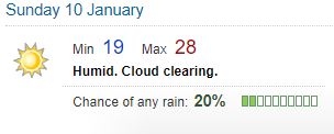 Dziękujemy. Twitter skorzysta z tych informacji, aby Twoja oś czasu bardziej Ci odpowiadała. CofnijCofnij
 -
A slow build up to today's max temp of 41°C in Perth and hot conditions elsewhere across the state. Perth will also be warm overnight, not dropping below 25°C. This arvo's sea breeze won't bring much cool relief either. Sunday will be cooler, but humid http://ow.ly/5buu50D2YzF pic.twitter.com/BKOLVkLuEB
 Dziękujemy. Twitter skorzysta z tych informacji, aby Twoja oś czasu bardziej Ci odpowiadała. CofnijCofnij
 -
The annual
#climate summary for#WesternAustralia is now available: 2020 was WA's 2nd warmest year on record; dry in the west, wet in the northern & central parts. We analyse all the weather over the past year, month by month, at http://ow.ly/dcUl50D2527#AnnualClimateStatementpic.twitter.com/81GzGSCZoCDziękujemy. Twitter skorzysta z tych informacji, aby Twoja oś czasu bardziej Ci odpowiadała. CofnijCofnij -
Bureau of Meteorology, Western Australia podał/a dalej
The numbers are in, 2020 was Australia’s 4th warmest year on record, 1.15 °C above average. For Australia as a whole, annual rainfall was 4% above average at 483.4 mm. Find out more in our
#AnnualClimateStatement for 2020: http://ow.ly/OqMq50D24QU@WMOpic.twitter.com/SrOHYo2bP5Dziękujemy. Twitter skorzysta z tych informacji, aby Twoja oś czasu bardziej Ci odpowiadała. CofnijCofnij -
2021's 2nd sea breeze has finally arrived in the Perth metro. Unfortunately hot air over the ocean means the cool relief it typically brings isn't occurring this time round. The last time the sea breeze stayed away for 5 consecutive days was in Feb 2008 http://ow.ly/JhNN50D25Nn pic.twitter.com/Ivfw14dwem
 Dziękujemy. Twitter skorzysta z tych informacji, aby Twoja oś czasu bardziej Ci odpowiadała. CofnijCofnij
 -
Perth metro's 2nd sea breeze of the year will arrive later today. A high pressure system has created strong easterlies that keep it at bay since Jan 2. It will bring temperature relief for the coast, but changing winds can be difficult for fighting fires http://ow.ly/8bve50D20vO pic.twitter.com/XhtOr2vNAv
 Dziękujemy. Twitter skorzysta z tych informacji, aby Twoja oś czasu bardziej Ci odpowiadała. CofnijCofnij
 -
Prepare for more hot days and uncomfortably warm nights across most of the WA coast and adjacent inland areas. Severe to extreme fire danger ratings are forecast for WA over the next few days, as are heatwave conditions. Check
@dfes_wa and forecasts here http://ow.ly/Zr9J50D10qB pic.twitter.com/U5ed2crMeVDziękujemy. Twitter skorzysta z tych informacji, aby Twoja oś czasu bardziej Ci odpowiadała. CofnijCofnij


Wydaje się, że ładowanie zajmuje dużo czasu.
Twitter jest przeciążony lub wystąpił chwilowy problem. Spróbuj ponownie lub sprawdź status Twittera, aby uzyskać więcej informacji.