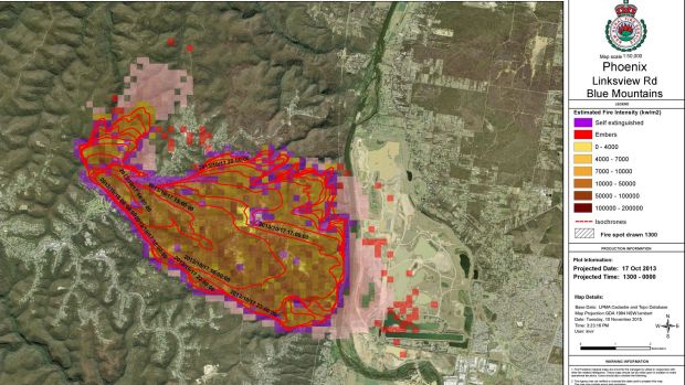
With Australia set to have another fierce fire season in the following months thanks to a strengthening El Nino and declining rainfalls, firefighters and planners are turning to an Australian-made bushfire simulator to help them do their job.
Called Phoenix, this software is proving to be indispensable in a number of different ways, from planning fire prevention, to knowing where a new fire will spread, to helping at-risk communities develop bushfire survival plans.

Initially instigated by Dr Kevin Tolhurst AM at the University of Melbourne, it's taken a decade of work from Dr Tolhurst and numerous other projects to bring Phoenix into the highly usable state that it is now. It turns out that modelling the behaviour of something as complex as fire is a very tricky problem, especially as it varies so wildly depending on the fuel found in different areas.
According to Dr Tolhurst, one of the biggest issues was how to model the smoke plume created by a fire. This proved to be very important, as it leads to the creation of firebrands – the pieces of burning bark and wood that are carried by the smoke and lead to spot fires.

In some situations, these firebrands can travel tens of kilometres downwind from the original fire, causing, "firestorms to develop and quickly entrap people and wildlife, so it is important to be able to know when spotting is going to occur and play a big part in the fire", Dr Tolhurst said.
Another key issue with modelling fires is the fuel that it burns, and early versions of Phoenix lacked the accurate fuel maps that it now has access to.
In NSW, the NSW Rural Fire Service has worked with National Parks and Wildlife to produce a state-wide vegetation map, while Victoria's Department of Environment, Land, Water and Planning (DELWP) relies on internal teams to gather the data, which are then used to create state-wide fuel maps. Regardless of where it's coming from, both states have found Phoenix's accuracy to be greatly improved since the creation of the high detail fuel maps.
Lee Miezis, executive director, fire and emergency management at DELWP, ran simulations of past fires to test it.
"We compared it to a number of specific fires, including Ash Wednesday 1983 and Black Sunday 2009, and generally it's proven to be quite accurate in capturing the general extent, speed, progression, movement and intensity. It even predicted some of the spot fires that occurred."
In the past, fire behaviour analysts (FBANs) had to manually plot the trajectory of a new fire. Andy Ackland is one of the senior FBANs at DELWP in Victoria, and explained how time-consuming the old method was.
"Manual predictions can take 30 minutes to an hour for a single fire, yet Phoenix can cover 20 predictions in minutes," Mr Ackland said. "The older methods of using spreadsheets and maps are good, and are part of our base training, but when you have lots of fires coming through it's very hard to stay on top of the predictions for so many different fires."
As well as being used in the field during fires, helping firefighters anticipate where to use their resources best, Phoenix can be used in the days prior to a predicted fire day to forecast where trouble areas might crop up.
But perhaps the most important use is in educating communities that are at risk from bushfires. Mr Miezis sees this as being a huge use of the tool in the coming years.
"It's a tool that makes it very real for communities, and to be able to do that ahead of the fire is very, very powerful," he siad.
"It helps get people to work on their fire plan, to act, to think about what they would do if a fire is bearing down on their home. It gets them into the mind-set to make smart decisions early, rather than act as it's happening."