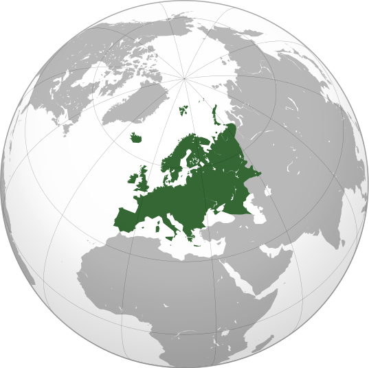
File:Europe orthographic Caucasus Urals boundary.svg
From Wikipedia, the free encyclopedia

Size of this PNG preview of this SVG file: 537 × 536 pixels. Other resolutions: 240 × 240 pixels | 481 × 480 pixels | 601 × 600 pixels | 769 × 768 pixels | 1,026 × 1,024 pixels.
Original file (SVG file, nominally 537 × 536 pixels, file size: 197 KB)
File history
Click on a date/time to view the file as it appeared at that time.
| Date/Time | Thumbnail | Dimensions | User | Comment | |
|---|---|---|---|---|---|
| current | 19:25, 3 March 2016 |  | 537 × 536 (197 KB) | Denniss | Reverted to version as of 13:27, 19 October 2014 (UTC) |
| 18:37, 3 March 2016 |  | 537 × 536 (239 KB) | IrakliGuna | UC UC UC | |
| 13:27, 19 October 2014 |  | 537 × 536 (197 KB) | Deni Mataev | Again, The entirety of Georgia is not in Europe geographically, only North Eastern parts are | |
| 20:05, 18 October 2014 |  | 537 × 536 (238 KB) | Politologia | Reverted to version as of 10:57, 18 October 2014 In all maps Georgia is part of Georgia. There is at list 10 versions of borders of Europe in most of them Georgia is part of Europa | |
| 20:04, 18 October 2014 |  | 537 × 536 (238 KB) | Politologia | Reverted to version as of 10:57, 18 October 2014 In all maps Georgia is part of Georgia. | |
| 12:19, 18 October 2014 |  | 537 × 536 (197 KB) | Deni Mataev | Reverted to version as of 13:35, 3 June 2014 Georgia as of whole is not part of Europe geographically | |
| 10:57, 18 October 2014 |  | 537 × 536 (238 KB) | Politologia | Updated Accuracy of borders | |
| 13:35, 3 June 2014 |  | 537 × 536 (197 KB) | Rob984 | Removed margin and added gradient. | |
| 19:55, 19 January 2014 | No thumbnail | 541 × 541 (199 KB) | Chipmunkdavis | Reverted to version as of 06:45, 11 April 2011 Very strange to have non-oceanic water shown only in the green bit of the map | |
| 19:01, 18 January 2014 |  | 541 × 541 (184 KB) | Fulvio314 | Cyprus light green. See [https://en.wikipedia.org/wiki/Cyprus#cite_note-13]. | |
| 06:45, 11 April 2011 |  | 541 × 541 (199 KB) | Dbachmann |
File usage
More than 100 pages link to this file. The following list shows the first 100 page links to this file only. A full list is available.
- Americas
- Asia
- Atlantis
- Coat of arms
- Coat of arms of Albania
- Coat of arms of Andorra
- Coat of arms of Armenia
- Coat of arms of Austria
- Coat of arms of Belgium
- Coat of arms of Bosnia and Herzegovina
- Coat of arms of Bulgaria
- Coat of arms of Croatia
- Coat of arms of Lithuania
- Coat of arms of Poland
- Coat of arms of Sweden
- Coat of arms of Åland
- Europe
- Financial and social rankings of sovereign states in Europe
- Flag of Albania
- Flag of Andorra
- Flag of Armenia
- Flag of Austria
- Flag of Azerbaijan
- Flag of Belarus
- Flag of Belgium
- Flag of Bosnia and Herzegovina
- Flag of Bulgaria
- Flag of Croatia
- Flag of Cyprus
- Flag of Denmark
- Flag of England
- Flag of Estonia
- Flag of Europe
- Flag of Finland
- Flag of France
- Flag of Georgia (country)
- Flag of Germany
- Flag of Gibraltar
- Flag of Greece
- Flag of Greenland
- Flag of Guernsey
- Flag of Hungary
- Flag of Iceland
- Flag of Italy
- Flag of Jersey
- Flag of Kazakhstan
- Flag of Latvia
- Flag of Liechtenstein
- Flag of Lithuania
- Flag of Luxembourg
- Flag of Malta
- Flag of Moldova
- Flag of Monaco
- Flag of Montenegro
- Flag of Northern Ireland
- Flag of Norway
- Flag of Poland
- Flag of Portugal
- Flag of Romania
- Flag of Russia
- Flag of San Marino
- Flag of Scotland
- Flag of Serbia
- Flag of Slovakia
- Flag of Slovenia
- Flag of Spain
- Flag of Sweden
- Flag of Switzerland
- Flag of Turkey
- Flag of Ukraine
- Flag of Vatican City
- Flag of Wales
- Flag of the Czech Republic
- Flag of the Faroe Islands
- Flag of the Isle of Man
- Flag of the Netherlands
- Flag of the Republic of Macedonia
- Flag of the Soviet Union
- Flag of the United Kingdom
- Gallery of country coats of arms
- Hyperborea
- Kalahari Desert
- Laurasia
- Lemuria (continent)
- List of sovereign states and dependent territories by continent
- Mu (lost continent)
- National emblem of Azerbaijan
- National emblem of Belarus
- Nemo me impune lacessit
- North America
- Oceania
- Old World
- Region
- Rodinia
- Royal Arms of England
- Royal coat of arms of the United Kingdom
- South America
- Sundaland
- Supercontinent
- Terra Australis
Global file usage
The following other wikis use this file:
- Usage on ace.wikipedia.org
- Usage on ady.wikipedia.org
- Usage on af.wikipedia.org
- Usage on ar.wikipedia.org
- أوروبا
- بوابة:آسيا
- بوابة:أوروبا
- بوابة:تركيا
- بوابة:تركيا/بوابات شقيقة
- بوابة:جغرافيا/مقالة مختارة/أرشيف
- بوابة:أوروبا/واجهة
- بوابة:تصفح
- بوابة:تصفح/جغرافيا
- قائمة رموز اتصال الدول
- بوابة:إسطنبول
- بوابة:آسيا/بوابات شقيقة
- ويكيبيديا:مقالة الصفحة الرئيسية المختارة/398
- بوابة:جغرافيا/مقالة مختارة/21
- حقوق المثليين في أوروبا
- اصلاح ديني
- Usage on arz.wikipedia.org
- Usage on as.wikipedia.org
View more global usage of this file.

