Synoptic
Wednesday
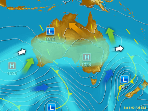
A series of troughs are producing showers and a few storms over parts of WA, NT and QLD. A cold front is producing isolated showers over southern VIC and TAS. A ridge of high pressure is keeping southern parts of WA and much of NSW and SA mostly dry and clear.
Issued Wednesday 11:45 EDT
Wednesday - Latest
A series of troughs are producing showers and a few storms over parts of WA, NT and QLD. A cold front is producing isolated showers over southern VIC and TAS. A ridge of high pressure is keeping southern parts of WA and much of NSW and SA mostly dry and clear.

Thursday 22:00 EDT
A low pressure trough over the adjacent interior will trigger thundery outbreaks of rain over inland parts of WA, northwestern SA and the NT. A high pressure system will keep the remainder of SA, NSW and VIC mostly dry. Cool westerlies will deliver a few showers to TAS.

Friday 22:00 EDT
A front and trough will bring areas of rain to TAS and a few showers to southern VIC. A broad low pressure trough in the tropics will produce thundery outbreaks of rain to parts of QLD, the NT and WA. A broad high pressure ridge will keep the remainder of WA and SA clear and dry.

Saturday 22:00 EDT
Tropical instability will trigger thundery showers over , northern QLD, NT's Top End and WA's Kimberley. A pair of low pressure troughs will deliver blustery showers over parts of VIC and TAS. A broad high pressure ridge will keep elsewhere mostly dry and clear.

Sunday 22:00 EDT
A broad high pressure system will keep the majority of SA, NSW, VIC and inland QLD clear and dry. A series of low pressure trough in the tropics will produce showers and thunderstorms. A low pressure trough over WA will bring gusty and showery cool change.

Monday 22:00 EDT
A low pressure system and associated troughs will bring a gust cool change to southern parts of WA, SA and VIC, and rain to TAS. A series of low pressure troughs over the tropics shall trigger thundery showers. A high pressure ridge will keep the bulk of QLD and NSW dry.
Tuesday 22:00 EDT
A complex low pressure system and associated troughs will impact the southeast, bringing rain to TAS and southern VIC, and a cool change across SA, VIC and NSW. A series of low pressure troughs over the tropics will produce showers and storms to parts of WA, the NT and QLD.
Based on information from the
Bureau of Meteorology and other providers
Sponsored Links
Herald Sun Synoptic charts below provide isobar, rainfall probability and wind stream direction probability for the Melbourne area and across Australia. The maps show the chronological weather pattern change at 10pm each day for the next 7 days.