Australian Weather

National Summary
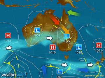
A series of troughs are producing showers and thunderstorms over the NT and WA interior, with some severe storms over southeast QLD. A cold front is causing showers over VIC and TAS. A ridge of high pressure is keeping southern WA and NSW mostly clear.
State Weather
Click for state forecasts


National Synoptic
Videos
Weather News
Stormy afternoon in Queensland
14:16 EDT
Thunderstorms are developing over Queensland this afternoon and they could become severe in the southeast.
Wet Melbourne Cup
13:56 EDT
Showers plaguing Melbourne Cup day celebrations across the host city today will affect the this year's race.
After the flood: Paintings by young Nauiyu artists hung in Darwin gallery
18:26 EDT
Some people can fish, some people can paint, but 11-year-old Tyson Cronin can do both.


Extremes and Records
| Current Extremes | Last 3 Days Extremes | Extremes This Month | |||
|---|---|---|---|---|---|
| Sat 29/10 | Sun 30/10 | Mon 31/10 | |||
|
42.6°C Fitzroy Crossing Ap, WA |
Hottest |
43.7°C Rabbit Flat, NT |
43.8°C Urandangi, Qld |
43.5°C Marble Bar, WA |
43.3°C Marble Bar, WA |
|
-0.4°C Mt Wellington, Tas |
Coldest |
0.0°C Wandering, WA |
-6.3°C Thredbo Top Station, NSW/ACT |
-5.5°C Mt Hotham, Vic |
-5.5°C Mt Hotham, Vic |
|
WNW 75km/h Scotts Peak Dam, Tas |
Windiest |
125km/h Mt Hotham, Vic |
131km/h Maatsuyker Is, Tas |
112km/h Coffs Harbour, NSW/ACT |
- |
|
2.6mm last hr Coldstream Comparison, Vic |
Wettest |
40.0mm Yangan, Qld |
48.3mm Thredbo Village, NSW/ACT |
109.2mm Christmas Island Ap, WA |
109.0mm Christmas Island Ap, WA |
| Australia's Records for November | |||
|---|---|---|---|
| Max | Min | Rain | |
| Highest 48.7°C at Birdsville Police Station, Qld in 1990 Lowest -3.1°C at Thredbo Top Station, NSW/ACT in 1967 |
Highest 35.0°C at Cunnamulla, Qld in 1965 Lowest -20.6°C at Mt Hotham, Vic in 1990 |
Highest 398.8mm at Moreton, Qld in 1909 |
|
-
Display your Local Weather here
automatically each time you visit us:

Rotates through Temperature,
Wind, Humidity and RainUse the Search Bar above
to find your Local, and go to the Local page
Click "Set My Local"
button next to the location name


