The Fulton Center isn’t a great building, but it does have its moments.
It’s rush hour in Fulton Center and thousands of black-coated commuters stream into the glass building through entrances on Broadway and Fulton Street and funnel down to the hovering circular concourse before branching off to further descend to the many tunnels that transverse New York’s five boroughs. A steady hum of voices backgrounds the incessant chirp-crank, chirp-crank of the subway turnstiles and the occasional click of digital shutters Instagramming the conical metal dome that dominates New York City’s shiny new transit nexus, which is already being called downtown’s Grand Central Terminal. Building anything so complex — especially infrastructure, especially in lower Manhattan — is an impressive feat, but it takes more than efficient planning and techno-artistry to make a space grand…
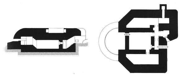
Observation post (with container). These drawings, taken from Bunker Archeology, show just how massive these structures are. The heavy black lines represent solid concrete but remind me of the poché on a Beaux-Arts-style drawing.
“One of the essential characteristics of the bunker is that it is one of the rare modern monolithic architectures.” So writes philosopher-artist-dromologist Paul Virilio in his exegesis of World War II defensive fortifications, Bunker Archeology. These poured-in-place pillboxes aren’t just modern, they’re modern concentrate—efficiently constructed for a single purpose and devoid of any style or ornament because, as Virilio writes, “the omnipotence of arms volatilized what was left of aesthetic will.” If Le Corbusier’s houses are machines for living, the concrete bunker is a machine for surviving, designed to stand against bombs, bullets, gases, and flames. But in parts of the world where war is now a fading memory, bunkers linger on this earth without purpose, decaying, tied inextricably to the past, a haunting reminder of violence, a ghostmodern architecture.
Some of these underground bunkers were incredibly expansive, intended for long-term occupation, but many others were martial follies. Today, they’re half-buried along coastlines or looming silently and mysteriously in the middle of cities, too massive to be destroyed but often too difficult to be repurposed. Apparently, a side effect of being built to withstand mortar attacks is the ability to confound planners and developers—perhaps there’s a lesson there. Yet despite the difficulty of renovating a structure with a wall thickness measured in feet, some enterprising organizations and architects are doing just that, appropriating bunkers to imbue them with a new life and new meaning.
Blåvand Bunkermuseum by BIG, Varde, Denmark
BIG’s Blåvand Bunkermuseum reconstructs the bunker’s original cannon out of glass “as a ghost or a reflection of the war machine it was meant to be.” For Virilio, the removal of a cannon “deconsecrates” a bunker. By that logic, BIG’s project re-consecrates the structure for a new denomination. The canon, once an instrument of ruination, is now an instrument of illumination, a skylight above an exhibition space. BIG describes its design as the “antithesis” to the existing structure: “vacuum rather than volume—transparency rather than gravity.” These are themes that recur in many of these projects.
Among architects, there seems to be renewed interest in Brutalism these days, and on purely aesthetic terms, it would be easy to think of these projects as examples of a New New Brutalism. After all, the Brutalist buildings of the 1950s and ‘60s were often derided as “bunkers,” although their raw concrete surfaces are more likely to harm their occupants than any invading military force. But like any good -ism, these projects represent both an aesthetic and an ethic. There’s actually a lightness to all these structures, an effort to mitigate the weight of the original bunker—and not just its literal weight. These bunkers carry a historic heaviness. They can be a psychological burden for people who don’t want to be reminded of the horror of war, but who are confronted by it every day, who literally live with it. While these renovations can’t erase the past, they can imbue its relics with new meaning.
Eliot R. Brown’s hand drawn map of Gotham. (Eliot R. Brown)
Gotham City is the perpetually dark comic book metropolis of alleys, asylums, caves, mansions, and of course, Batman. The Dark Knight of DC Comics celebrates his 75th anniversary this year but Gotham didn’t become the hometown of the Caped Crusader until 1940, when Batman co-creator Bill Finger named the city for the first time inBatman No.4. In the early days of comics, cities weren’t much more than rooftop set pieces and vaguely defined skylines, and Batman was ostensibly fighting crime in a generic city with a vague resemblance to New York, but, as Finger has said, “We didn’t call it New York because we wanted anybody in any city to identify with it.” However, since its inception Gotham has gained an identity as complex and unique as any real American metropolis and is now more closely associated with a single character than any other city in comics. Capital-M Metropolis comes close perhaps, but Superman’s city is nowhere near as interesting as Gotham, in part because Gotham has something that makes it more fully realized and more consistent in its representation than any other fictional city in comics or film: a map.
Gotham City limits were defined in 1998 in preparation for the “No Man’s Land Story” story arc, during which the city was cut off from the United States after nearly being destroyed by a cataclysmic earthquake. It was the comic book version of Escape from New York. However, before DC Comics could destroy Gotham City, there had to be a Gotham City to destroy. Enter artist and illustrator Eliot R. Brown, the cartographer of Gotham.
An early sketch of Gotham City, courtesy Eliot R. Brown
Brown has no formal training in cartography, but he did study architecture and had previously worked as a technical artist for Marvel Comics, where, as he told me, he was the closest thing they had to an “in-house architect and architectural renderer (and weapons designer and aerospace engineer).” He dreamt up and drew tech specs for Punisher’s weapons, Captain America’s experimental jet, and Iron Man’s armor, and the occasional superhero headquarters. But in 1998 when Brown was contacted by Denny O’Neil, a legendary comics writer and long-time Batman editor, he was faced with an even bigger request: design one of the most iconic cities in comics history. O’Neil wanted a map of Gotham as part of an in-house “bible” to help coordinate the various comics that would be affected by the earthquake. The first step for Brown was to meet with the writers and artists who shared their wish-lists for Gotham locales. As he recalls:
“The DC Comics editors made it clear that Gotham City was an idealized version of Manhattan. Like most comic book constructs, it had to do a lot of things. It needed sophistication and a seamy side. A business district and fine residences. Entertainment, meat packing, garment district, docks and their dockside business. In short all of Manhattan and Brooklyn stuffed into a … well, a nice page layout.”
Early development drawings for the map of Gotham, courtesy Eliot R. Brown
With research materials in hand and a mandate that Gotham had to be an island, Brown began, like Bill Finger, with the idea of a fictionalized Manhattan. Having grown up New York, he knew it well and used his knowledge of the city to plan its fictional counterpart, sprinkling in familiar neighborhoods, parks, civic buildings, monuments, landmarks and transit infrastructure.
The final, hand-drawn map of Gotham City by Eliot R. Brown
The city took shape in a week and, after some testy exchanges with editors and few back-and-forth faxes, Gotham’s rough coastline was finalized less than two months later. Brown’s final hand-annotated map of Gotham City included numerous bridges and tunnels ready to be dynamited by the U.S. government, as well as a few forgotten steam tunnels that might be useful to a crimefighter and his allies. Brown didn’t just design the city; he designed an implicit history that writers are still exploring.
Left two images: Eliot R. Brown’s map of Gotham City, as it appeared in comics circa 1999; right image: Brown’s map appearing in a recent issue of Batman
A few issues of the “No Man’s Land” story arc opened with a map of Gotham, illustrating the shifting boundaries of a turf war that was slowly won by Batman and the Gotham City Police Department. When “No Man’s Land” ended in 1999 and Gotham returned to the status quo, rebuilt with money from Bruce Wayne and Lex Luthor and buildings designed by Gotham planner and cartographer Eliot Brown, the map of Gotham City was officially made canon.
Gotham City as it appeared in promotional materials for Christopher Nolan’s The Dark Knight Rises (2012)
Since “No Man’s Land,” writers and artists have worked within the confines of Gotham’s borders and many versions of the map have been published. And some have even expanded them, including the current Batman team of writer Scott Snyder and artist Greg Capullo. A simplified version is used in video games and, most visibly, Brown’s map of Gotham was used in the recent Batman films directed by Christopher Nolan, as can be seen above in Bane’s strike map. Brown had no idea his map had been used in the new film trilogy but told me he was “delighted that they helped further the ‘reality’ of the books.”
While a map may seem like a small thing, especially for a fictional city, it really does make Gotham feel like more of a real place. So why don’t more comics map out their cities? Why isn’t there a definitive Metropolis or a definitive Star City? Besides the amount of work it takes, Brown thinks the imposition of an official map might just be too limiting for some writers and artists. “If a writer wants Batman to face Croc on a glacier-bound treehouse for mutants—then that’s what he writes and gets drawn. If, the next month, Batman is now chasing Harley Quinn at a 24-Hour Endurance Sports Car Race Track—poof, there it is. All right in Gotham City. Put in a better way, it is about allowing the writers to have their freedom.”
Ideally, a city would offer unlimited possibilities. But then again, restrictions can sometimes create the best art. Current Batman writer Scott Snyder has made extensive use of Gotham’s architecture and urban design as a reflection of Batman’s (and Bruce Wayne’s) consciousness and, in so doing, has told fascinating, layered stories rich with metaphor, history, and symbolism, including a mini-series, The Gates of Gotham, about the engineers who designed and built the many bridges that Eliot Brown created for Gotham. Brown no longer works in comics but since he created his map, writers and artists have continued to tell their stories within the confines of Gotham’s borders, and in so doing, have added to the city’s history, creating and exploring the nooks, crannies, alleys, and fire escapes of unique neighborhoods that were once nothing more than a name on paper.
Oh, and if you zoomed out a little on that map, where in the United States would you find Gotham City? New Jersey.
John McClane crawls through the mechanical spaces of Nakatomi Plaza in Die Hard.
The following essay on Die Hard, Kafka, Deleuze, The Towering Inferno, Inception, James Bond, Heating, Ventilation, and Air Conditioning originally appeared in Volume 37: Is This Not a Pipe?
Workers furnish Queen Mary’s Dollhouse in the drawing room of Lutyen’s London apartment (via The Queen’s Dolls’ House by Lucinda Lambton)
Edwin Lutyens (1869-1944) was one of the foremost British architects of the late 19th and early 20th centuries. Though his name may not be particularly well known today, he was one of very few contemporaries of Frank Lloyd Wright whose work the American architect not only admired, but openly praised to his students, despite the vast difference in their styles. Lutyens was known for designing exceedingly beautiful classically influenced country houses with exceedingly British names like Little Thakeham (1902), Heathcote (1906), Great Maytham (1912), and Benedict Cumberbatch, but his grandest commission was the plan for New Delhi and the enormous Viceroy’s House there. But right now, I want to take a closer look at the smallest house Lutyen’s ever designed: The Queen Mary’s Dolls’ House.
Like most good ideas, the dollhouse was conceived over glasses of champagne with a princess – in this case, Princess Marie Louise, granddaughter of Queen Victoria, who asked Lutyens to construct a massive dollhouse for her cousin Queen Mary. It took too three years for Lutyens and a team of 1,500 people –artists, craftsman, gardeners, and even vinters– to finish the project. It was constructed to be a paean to British craftsmanship and ingenuity and Lutyens insisted that every fixture be operable. The miniature gramophone plays, the sinks run hot and cold, and the library is filled with hundreds of tiny books (many written by prominent British authors specially for the library), and a wine cellar full of tiny, bottles of wine – perfect for those times you want to sit back and relax with a thimble full of wine. When it was completed in 1924, the Queen Mary’s Dolls’ House. was exhibited at the British Empire Exhibition. Built at the scale of one-inch equals one-foot, the five-foot-high dollhouse serves as a particularly fine record of the era’s architecture and can still be seen at Windsor Castle.