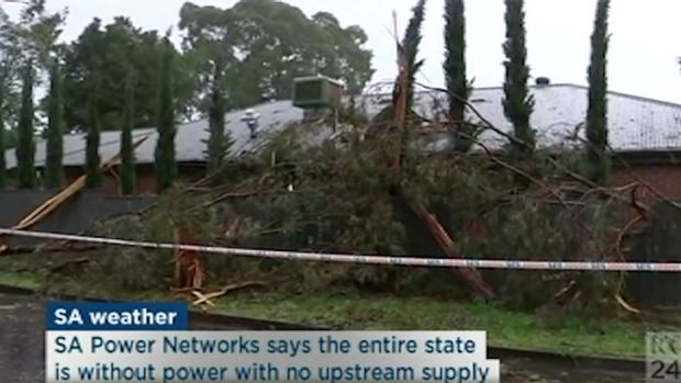
The once in 50-years storm that lashed South Australia's coastline is expected to skip Melbourne, but could batter already saturated parts of regional Victoria.
Up to 80 millimetres of rain could fall within six hours over parts of northern and western Victoria on Wednesday night, with more expected on Thursday, raising fears of flash flooding.
More News Videos
South Australia loses power supply
The entire state is without power after being lashed with severe storms. (Video courtesy ABC News 24)
Damaging winds up to 110km/h could also lash regional areas, as the complex low-pressure system crosses into Victoria's north-west overnight.
The fierce weather system that gripped South Australia on Wednesday afternoon, cut power to the entire state.
A mass blackout began about 3.30pm Wednesday afternoon, plunging Adelaide into darkness, grounding flights and causing havoc on the state's roads.
Traffic lights were rendered inoperational, choking roads in the CBD. Building fire alarms blared across the city, according to local media reports, and residents rushed to supermarkets to stock up on candles and matches.
Regional towns were battered by strong winds, which ripped roofs from houses and churches, uprooted trees and brought down powerlines.
"The worst of the wind will certainly miss [Melbourne]," Bureau of Meteorology senior forecaster Stephen King said. "The wind belt will move to above Mildura and then head to NSW."

"You could say it's a once in 50-years storm and it's affecting the coast of South Australia, but Victoria will largely miss out on that system."
Between 10 and 25 millimetres of rain is likely across most of Victoria, but some areas could receive as much as 50 millimetres.

In the north-east, Victorians could see isolated falls of up to 80 millimetres within a six to nine hour period, especially where there are thunderstorms.
Heavy rain may lead to flash flooding across the Mallee and Wimmera districts on Wednesday night, extending to the south-west and central districts overnight, and the north-east by Thursday morning.
"That's where there are risks of flash flooding, partly because everything in the north is wet already, so anything will cause minor flooding issues," Mr King said.
Mr King said another low-pressure system, intensifying over the Great Australia Bight, could generate more storms in central Victoria. He said thunderstorms could reach central Victoria by midnight, with rain expected between 3am and 9am on Thursday.
Melbourne can expect from 5 to 15 millimetres of rain between 3am and 9am on Thursday.
A severe weather warning is in place for Central, Mallee, South West, Northern Country, North Central, North East and Wimmera forecast districts.
The worst-affected towns include Mildura, Horsham, Warrnambool, Bendigo, Shepparton, Seymour, Maryborough, Ballarat, Geelong, Wodonga and Wangaratta.
Port August in South Australia has been belted with wind gusts of up to 83km/h, with more thunderstorms to come.
Parts of the Eyre Peninsula have been pummelled with large hailstones.
Victoria's emergency services are watching the weather and are ready to respond, an SES spokesman said.
"One of the key things facing Victoria over the next couple of days is the weather scenario," Victorian emergency management commissioner Craig Lapsley said.
"Tie down those things that will be blowing around and could become missiles. Make sure you don't go near water that's flooding ... it's unsafe to drive in water, play in water."
Meanwhile, a "watch and act" alert has been issued for the Great Ocean Road, where there has been more than 80 landslides since September 14.
"The largest [landslide] was almost 1000 tonnes of material [50-70 truck loads]. Ninety per cent of the landslides above the road have been assessed; 5 per cent below the road have been assessed due to difficulty in gaining access," according to the SES.
"VicRoads crews continue to work throughout the day, removing loose material from affected sites in the attempt to prevent further landslides occurring."
The SES is warning landslides continue to be a risk along sections of the road, but certain areas - including between Lorne and Cumberland River, and Separation Creek and Cumberland River - have been opened to small vehicles.
VICSESChief: RT vicemergency: Severe weather across Vic from Wednesday to Friday. High winds and heavy rainfall. S… pic.twitter.com/OzFeee4uif
— VICSES News (@vicsesnews) September 28, 2016
Get ready for a flood or storm. Be prepared, stay informed, monitor local conditions, and travel using recommended routes. pic.twitter.com/AfjnGNwwXW
— VICSES News (@vicsesnews) September 28, 2016


