


Outlook meeting to focus on AZ, NM, CO, UT and WY
 NIDIS and its partners are holding a Drought & Climate Outlook for the Intermountain West Drought Early Warning System (previously the Upper Colorado) on Tuesday, Sept. 20, to provide an update on current drought status and a preview of developing climatic events (i.e., El Niño and La Niña) for the region.
More information
Wyoming, S. Dakota publishing monthly drought information summaries

Both Wyoming and South Dakota are publishing drought information summaries in response to conditions in each state. For more information, contact Laura Edwards at South Dakota State University or Tony Bergantino at the Wyoming State Climate Office.
Report highlights Federal drought resilience activities through August 2016
 The Report to the Council on Climate Preparedness and Resilience, published August 31, 2016, highlights the National Drought Resilience Partnership’s accomplishments to date and provides an overview of some of the Administration’s work on drought response since 2009. It is the first of what will be regular updates on the NDRP’s commitment to work across federal agencies to deliver on-the-ground results.
How is Drought Affecting your Neighborhood?
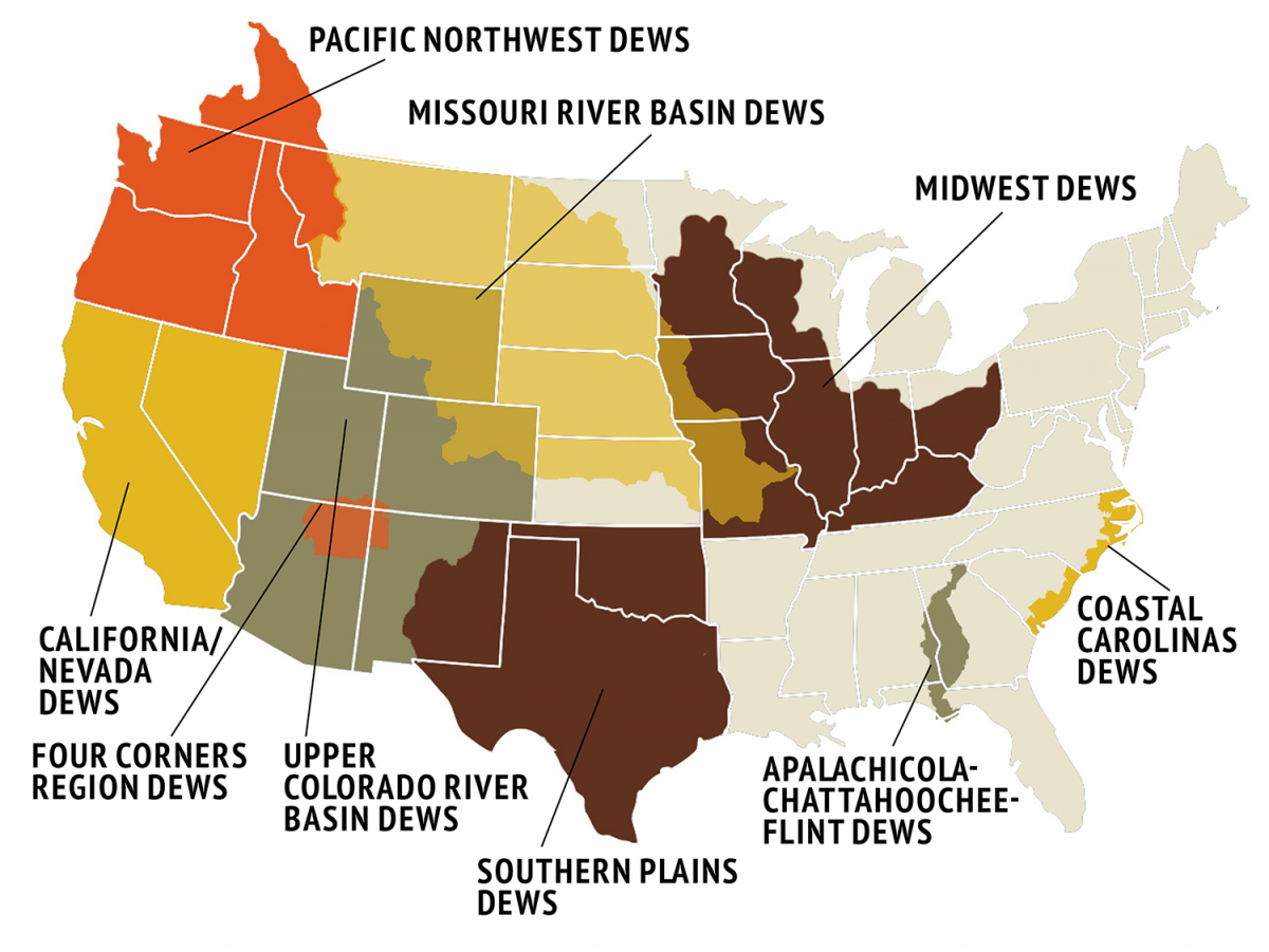
NIDIS Drought Early Warning Systems (DEWS)
DEWS are partnerships of federal, tribal, state, local and academic entities within specific watersheds and/or states. DEWS pages on this site provide climate and drought data, links to events, research, reports, planning resources, stakeholder lists and contacts within that watershed or area. Click on the menu below to link to DEWS features..

Regional Climate Centers and individual states
RCC region pages, organized by state groupings, offer links to applied climate research, including applicable U.S. Drought Monitor maps and statistics, and direct links to each RCC’s website, where users can find a depth of data, services and resources for that area. Click on the menu below to select an RCC or an individual state.

Drought in the News
Recent & Upcoming Events
- Drought and Climate in the ACF Basin - Town Hall Meeting Sept. 28
- Climate, Water and Drought Assessment for the Upper Colorado Basin - Oct. 4
- Climate, Water and Drought Assessment and Seasonal Forecast with Klaus Wolter - Sept. 27
- North Central U.S. Climate Summary and Outlook Webinar - Dec. 15
- North Central U.S. Climate Summary and Outlook Webinar - Nov. 17
- North Central U.S. Climate Summary and Outlook Webinar - Oct. 20
- North Central U.S. Climate Summary and Outlook Webinar - Sept. 15
- Applying Season-ahead Precipitation and Streamflow Forecasts to Guide Reservoir Allocations: Case Study of the Highland Lakes in Central Texas
Webinars
- Climate, Water and Drought Assessment and Seasonal Forecast with Klaus Wolter - Sept. 27
- Apalachicola-Chattahoochee-Flint River Basin Drought Assessment Webinar - Sept. 28, 2016
- Climate, Water and Drought Assessment for the Upper Colorado Basin - Oct. 4
- Apalachicola-Chattahoochee-Flint River Basin Drought Assessment Webinar - Oct. 11, 2016
- North Central U.S. Climate Summary and Outlook Webinar - Oct. 20
- Apalachicola-Chattahoochee-Flint River Basin Drought Assessment Webinar - Oct. 26, 2016
- North Central U.S. Climate Summary and Outlook Webinar - Nov. 17
- North Central U.S. Climate Summary and Outlook Webinar - Dec. 15