Australian Weather

National Summary
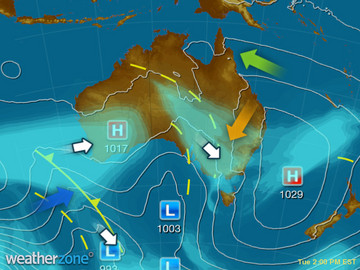
A deepening low pressure system and associated troughs are producing rain over NT, QLD, SA and NSW - heaviest over southwest QLD and northwest NSW. A moist onshore wind is triggering a few showers over QLD's east coast. Mostly dry over WA under a high pressure ridge.
State Weather
Click for state forecasts


Weather News
Queensland's winter delivers second wettest on record, BoM says
18:34 EST
Queensland has experienced its second wettest winter on record, and almost broke the record for warm overnight temperatures.
First spring soaking under way
16:23 EST
Rain and thunderstorms are spreading across southern and central Australia today as the first big system of spring pushes east.
Wine industry soon to have smartphone app advising on irrigation and harvesting
15:26 EST
The wine industry will soon have another tool at its fingertips to help navigate important on-farm decisions.


Extremes and Records
| Current Extremes | Last 3 Days Extremes | Extremes This Month | |||
|---|---|---|---|---|---|
| Tue 30/08 | Wed 31/08 | Thu 01/09 | |||
|
27.7°C Dum In Mirrie, NT |
Hottest |
36.5°C Katherine, NT |
37.7°C Douglas River, NT |
37.0°C Wyndham Ap, WA |
37.0°C Wyndham Ap, WA |
|
-1.3°C Mt Wellington, Tas |
Coldest |
-0.7°C Eyre, WA |
-0.7°C Thredbo Top Station, NSW/ACT |
6.0°C Blue Rock Reservoir, Vic |
-0.7°C Thredbo Top Station, NSW/ACT |
|
NW 53km/h Ballera Gas Field, Qld |
Windiest |
109km/h Mt Hotham, Vic |
81km/h Murrurundi Gap, NSW/ACT |
87km/h Mt Hartz, Tas |
- |
|
0.8mm last hr Point Stuart, NT |
Wettest |
96.0mm Rocky Valley, Vic |
70.1mm Thredbo Village, NSW/ACT |
6.0mm Blue Rock Reservoir, Vic |
7.0mm Woolbrook, NSW/ACT |
| Australia's Records for September | |||
|---|---|---|---|
| Max | Min | Rain | |
| Highest 43.1°C at West Roebuck, WA in 2003 Lowest -6.2°C at Mt Buller, Vic in 1995 |
Highest 29.7°C at Wyndham, WA in 2005 Lowest -16.7°C at Charlotte Pass, NSW/ACT in 1970 |
Highest 370.3mm at Burdekin, Qld in 1890 |
|
-
Display your Local Weather here
automatically each time you visit us:

Rotates through Temperature,
Wind, Humidity and RainUse the Search Bar above
to find your Local, and go to the Local page
Click "Set My Local"
button next to the location name


