Australian Weather

National Summary
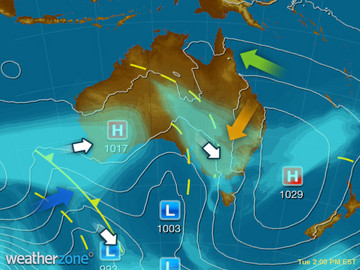
A trough is producing rain and thunderstorms over QLD. A cold and unstable airflow in the wake of a cold front is producing some showers over coastal SA, VIC and TAS. An cold front is bringing showers to southwestern WA. A high will bring a cold night to inland VIC and NSW.
State Weather
Click for state forecasts


Weather News
Thunderstorms about to fire in QLD
12:27 EST
Storm chasers in southern Queensland and northeastern New South Wales are getting excited for rare winter thunderstorms this afternoon.
Facebook post attracts hairdresser to outback Queensland town of Blackall
14:52 EST
One little Facebook post has made a huge difference to the outback Queensland community of Blackall, helping to attract a hairdresser to town.
New Zealand's North Island sitting under soggy skies
13:43 EST
Heavy rain is pounding New Zealand's North Island, and the next round of rain is not far behind.


Extremes and Records
| Current Extremes | Last 3 Days Extremes | Extremes This Month | |||
|---|---|---|---|---|---|
| Mon 08/08 | Tue 09/08 | Wed 10/08 | |||
|
34.2°C Derby Ap, WA |
Hottest |
35.6°C Brunette Downs, NT |
35.4°C Wyndham Ap, WA |
36.0°C Warmun, WA |
37.0°C Wyndham Ap, WA |
|
-4.4°C Thredbo Top Station, NSW/ACT |
Coldest |
-4.0°C Cooma, NSW/ACT |
-2.5°C Mt Buller, Vic |
-5.3°C Thredbo Top Station, NSW/ACT |
-10.4°C Thredbo Top Station, NSW/ACT |
|
W 59km/h Hogan Island, Vic |
Windiest |
100km/h Cape Leeuwin, WA |
118km/h Thredbo Top Station, NSW/ACT |
111km/h Hogan Island, Vic |
- |
|
0.2mm last hr Shannon, WA |
Wettest |
36.0mm Babinda, Qld |
40.4mm Liawenee, Tas |
31.6mm Melbourne Bay, Tas |
24.0mm Smithton Ap, Tas |
| Australia's Records for August | |||
|---|---|---|---|
| Max | Min | Rain | |
| Highest 40.2°C at Cape Don, NT in 2014 Lowest -6.7°C at Mt Hotham, Vic in 2005 |
Highest 28.7°C at Milikapiti, NT in 1973 Lowest -20.6°C at Charlotte Pass, NSW/ACT in 1968 |
Highest 529.2mm at Rainbow Beach, Qld in 2007 |
|
-
Display your Local Weather here
automatically each time you visit us:

Rotates through Temperature,
Wind, Humidity and RainUse the Search Bar above
to find your Local, and go to the Local page
Click "Set My Local"
button next to the location name


