06/07/2016-06/13/2016
Data-driven styling for live earthquake tracking [1] | the real time earthquake map
Mapping
- It looks like the new mapping function of Maps.me creates some false data in OSM (automatic translation from German). Some mappers are collecting questionable edits on a wiki page.
- User JIDB improved his proposal posted in April about extending the tagging of Kneipp facilities based on users comments. Kneipp facilities (in German) are popular in German speaking countries.
- An ambitious discussion takes place on the tagging mailing list about turn lanes.
- Kevin Kohler starts a discussion about bus route 95A (automatic translation) where the route has two variants, one of which only runs once a day in each direction. The discussion centres around what happens if someone uses OSM and thinks they are on the frequent part of the route when they are not and how can it be tagged or indeed how should it be tagged.
- User Amacri posted a request for a new tag
natural=uplandas type way or to enable the use of type «way» for the tag «place». Currently, the tagplace=isolated_dwellingis defined as node or a polygon (area), but not as a way. - A call for a tree mapping party in Basaveshwaranagar (India) on ‘The World Environment Day’.
- A tweet announcing that OSM France is present at the Fujitsu World Tour.
- A cool project to visualize OSM data in 3D and split vertically by year. The developer of the project used the OSM Postgis Script to load the data into PostGIS. The result is a 3D map which can be navigated.
Community
- A paper entitled «Guided Classification System for Conceptual Overlapping Classes in OpenStreetMap» has been just published in the International Journal of Geo-Information. The paper aims at contributing to the validation of OSM datasets. A web-based application called Grass&Green was implemented which provides recommendations for crowdsourcing validation. This research encourages the development of customized applications that target a particular geographic feature.
Imports
- Wojciech Myrda documented his import of GDOS data in Poland.
OpenStreetMap Foundation
- The OSMF License Working Group has submitted the text of the Collective Database Guideline to the OSMF Board for a decision. There is a discussion concerning this matter on the mailing-list Legal-Talk.
Events
- State of the Map US 2016, will be held at Seattle University on the 23rd to the 25th of July and will focus on the importance of free map data in humanitarian efforts of organizations, ranging from Microsoft and the American Red Cross to the Tacoma Fire Department. More information here.
- OSM talks resume at RIOSCRAM 2016 — ISCRAM Conference in Rio de Janeiro.
Humanitarian OSM
- The Humanitarian OpenStreetMap Team of the University of Vermont reported on its activities in recent months in response to the disasters in Ecuador and Sri Lanka.
- Nirab Pudasaini reports in opensource.com on the role of OSM and other Open Data/Humanitarian projects after the devastating earthquake in Nepal 2015. In summary he explains: Opensource projects save lives.
- Dale Kunce provides in Missing Maps blog a compilation of detected road kilometers, depending on the acquisition year. As examples he uses the United States, the Philippines and Guinea. He thinks that this can indicate which areas are still relatively unmapped.
- On the HOT mailing list some papers on the effective impact of disaster mapping are collected.
Maps
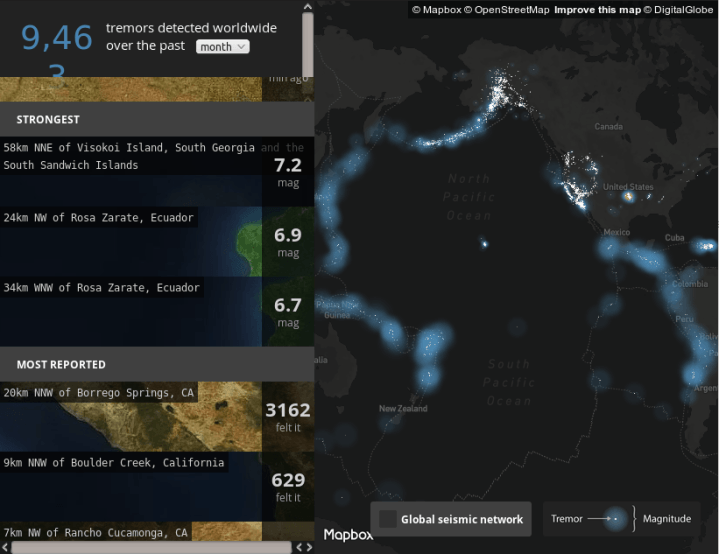
- [1] Peter Liu from Mapbox uses the data from USGS (US Geological Survey) and created a real-time map of all earthquakes, which are measured by the USGS. Please be patient, retrieving more than 9000 quakes of this month takes some time. 😉 Hover over each marker to inspect the quake, and click to zoom in and view satellite imagery of the surrounding area.
- The center of Berlin is now represented in Minecraft. The map is based on open geodata from the Berliner Datenportal and OpenStreetMap. It was developed by con terra using FME ™ technology. The map can be downloaded and used freely.
- The piano map is quite new and not yet listed in the map collection.
Open Data
- A paper published at AGILE (A conceptual model to assess the quality of volunteered geographic information for the purpose of flood management that combines cross-platform data, i.e. OpenStreetMap and social media data, and authoritative data. This model is part of an ongoing research for the development of an approach for quality assessment of VGI in flood situations from citizen observers. (Update — Link to the paper fixed!)
- Karin Lindström reports
 in ComputerSweden on the release of official maps in Sweden (automatic translation). Users Skinfaxi opened a discussion in the German forum in which it is recognised that these data are not yet OSM-compatible (automatic translation).
Licences
- Mapbox has set up a support point for attribution issues on Mapbox hosted maps.
- Sven Geggus asks
 (automatic translation) at mailing list Talk-de if there are leading cases about the usage of registered trademark symbols in maps.
Software
- Users yogesh10446 points to the Android app mymap. It offers offline maps for Nepal and makes it possible to share location with friends and to edit OSM data as well.
Programming
- James Halliday explains with more technical details how osm-p2p works. The project is a decentralized peer-to-peer database for storing and editing OpenStreetMap data.
- As part of his GSoC project Zabot worked on generating perlin noise to suppress the otherwise visible texture repeats.
- Meteopool.org who make maps for storm chasing and weather watching, wrote about (automatic translation) their switch to OpenLayers 3 and forthcoming relaunch. They are also looking for a student developer or keen storm chaser to help them in creating three smartphone apps.
- The planet dump which is usually published on Thursday was delayed by a few days because a very long comment at a changeset discussion made a script crash.
- Stefan Hahmann reports about an older publication of his about generating incline values for street networks based on GPS traces from OpenStreetMap. Those values might be used for energy-efficient routing or they might be used to reconstruct more detailed elevation data with a method presented in Germany last year.
Releases
| Software | Version | Release Date | Comment |
|---|---|---|---|
| Overpass-Turbo | 2016-06-06 | 6.6.2016 | — |
| Maps.me iOS | 6.1.9 | 7.6.2016 | Bug fixes, new map data files |
| iD | 1.9.6 | 8.6.2016 | — |
| libosmium | 2.7.3 | 8.6.2016 | faster output of OSM files in format of XML, OPL or debug format |
| Maps.me Android | var | 8.6.2016 | Bug fixes, new map dada files |
| Osmium Tool | 1.3.1 | 8.6.2016 | new parameters and command line switches |
| Route Converter | 2.18 | 8.6.2016 | see release information itself |
| Mapillary Android | 2.22 | 13.6.2016 | bug fixes and extended features |
| OSRM Backend | 5.2.1 | 13.6.2016 | bug fix version to 5.2.0 |
Provided by the OSM Software Watchlist
Did you know …
- … the Blender tutorial «Creating a Realistic City With OpenStreetMap in Blender»? On Lesterbanks.com you can see the 90 minutes video with impressive results.
- … the page who shows you an overview of GIS formats?
OSM in the media
- Chefuturo.it:
 In Lecce, Apulia, 80 volunteers got together along with the disabled people to capture more than 1,100 barriers in town and mapped them. (automatic translation)
Other “geo” things
- Justin O’Beirne, former head of department at Apple Maps, did a detail analysis of the differences between Apple and Google Maps. The analysis are divided into 4 parts, the part 1 is about the content and their descriptions. The next parts will be published in the following weeks.
- The Indian government denies permission to Google Street View over security concerns.
- Google has developed OpenLocationCode from its Zurich engineering office. With the help of this system a location should be easier to relate to than using Latitude/Longitude. The code is available on Github. The addresses can [be determined] on the map (https://plus.codes/6PVH0000) such as:
- Olympiastadion, Berlin, Germany 52.51462/13.23952 or
- Tatro Carlos Marx, Havanna, Cuba, 23.12933/-82.41934 or
- Macchu Picchu, Peru, -13.16399/-72.54453 or
- An article in Wired about Transitland, which collects and standardizes real-time public data sets for public transport. This service, offered by mapping platform Mapzen, provides developers with public transport data of more than 200 regions.
- Current geoinformation is economically more valuable. This is the result of a survey of swisstopo and the Swiss organization for geographical information (SOGI).
Upcoming Events
| Where | What | When | Country |
|---|---|---|---|
| Esino Lario | Mapping party in preparazione di Wikimania 2016 | 06/18/2016-06/19/2016 |  |
| Nottingham | Nottingham | 06/21/2016 |  |
| Rapperswil | Swiss PG Day 2016 | 06/24/2016 |  |
| Kyoto | 京都世界遺産マッピングパーティ:最終回 天龍寺 | 06/25/2016 |  |
| Sliač | Mapping párty Sliač | 06/25/2016 |  |
| Colorado | Saturday Mapternoon, Evergreen | 06/25/2016 |  |
| Graz | Stammtisch | 06/27/2016 |  |
| Montpellier | Rencontre mensuelle | 06/29/2016 |  |
| Antwerp | Missing Maps @ IPIS | 06/29/2016 |  |
| Shizuoka | OpenStreetMapワークショップ in 日本平 (Nihondaira) | 07/02/2016 | |
Note: If you like to see your event here, please put it into the calendar. Only data which is there, will appear in weeklyOSM. Please check your event in our public calendar preview and correct it, where appropiate..
This weekly was produced by Hakuch, Laura Barroso, Nakaner, Peda, Rogehm, Softgrow, derFred, jinalfoflia, mgehling, seumas, stephan75, wambacher, widedangel.
 The Map Age Guide from xkcd (
 at TEDx Havana about how he is looking forward to «put Cuba on the map» (OpenStreetMap that is) despite limited internet access.


