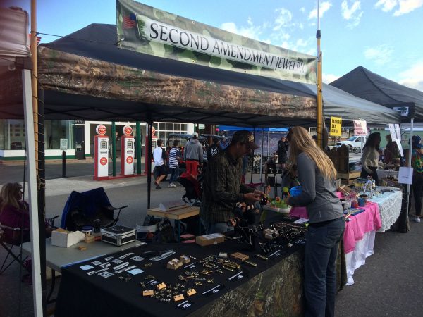
Aucklands newest and one of its most prominent cycleways was opened this morning on Quay St by John Key along with transport minister Simon Bridges, Mayor Len Brown and a host of other officials. The opening was certainly helped by the thunderstorms of we had overnight easing and the clouds even parting to make for a calm winter morning.
John Key, Simon Bridges, Len Brown and AT Chairman Dr Lester Levy all spoke before the ribbon was cut. I thought all spoke well about the need for us to develop integrated networks that are safe for all and not mixed with other vehicles like cars and buses. Lester also put his health hat on reminding people that on top of the transport benefits of being about to move a lot more people in the same about of space, those cycling also tend to be healthier which has benefits to the health system.
After the speeches it was time to cut the ribbon and for officials to take a ride.
Like other cycleways, AT have installed cycleway counters but for the first time they’ve also added a visible counter so everyone can see how many people have passed every day and year.
I suspect this will quickly become the busiest cycleway in Auckland. Before and even during the speeches there were cyclists passing by on a fairly frequent basis.
As part of the project the entry to the port has also been made safer.
Congratulations to everyone involved in making this project happen..
Here’s the official release from AT on it which also highlights that there are a couple of consultations for other major project coming up soon including Ian McKinnon Dr later this month.
Auckland’s waterfront will be an improved urban space and an even busier cycle route following the opening of the Quay St Cycleway today.
The Prime Minister, Transport Minister Simon Bridges, Mayor Len Brown and a large group of people on bikes, were the first to use the city centre’s newest cycleway. The opening was preceded by a dawn blessing with Iwi representatives.
A new cycle counter on the promenade, a first for Auckland, will highlight the number of people cycling along one of Auckland busiest routes.
On the waterfront side of Quay St, the 1km, two way cycleway goes from Princes Wharf at Lower Hobson St to Plumer St. The $2.18m cycleway is being delivered by Auckland Transport and has local funding and an investment from the Government through NZ Transport Agency and the Urban Cycleways Programme.
It will benefit everyone who spends time at the waterfront and will encourage more people to start cycling into the city centre says Kathryn King, Auckland Transport’s Cycling and Walking manager.
“Having a dedicated cycleway like this means there is more space on the promenade for people to walk and enjoy the harbour views. The planter boxes, which provide protection from traffic, improve this wonderful space by adding some greenery.
“The cycle route into the city centre along Tamaki Dr is the busiest route in Auckland, and this will make cycling from the east even more attractive. Providing a protected cycleway on Quay St gives people working in the downtown area greater travel choice and an excellent cross-town route that avoids a lot of city traffic.”
Mayor Len Brown says it’s another important chapter in his vision for Auckland as the world’s most liveable city as it transforms the city centre into a pedestrian and cycle friendly destination.
“This project is another example of Auckland Council, Auckland Transport and the Transport Agency working well together to achieve a great outcome.”
Bike Auckland, chair, Barbara Cuthbert says the cycleway is a great addition to downtown Auckland. “It’s hugely exciting to have a safe separated space for people cycling and those walking close to rail and ferry services.”
Map QuaystThe three-metre-wide cycleway connects with the Beach Rd Cycleway at Britomart Pl and by the end of 2018 will link with the Nelson St Cycleway and Westhaven to City Cycleway at Princes Wharf and the Tamaki Dr Cycleway.
When phase two of Nelson St Cycleway is constructed next year, the city centre cycle loop will be complete. This loop includes Lightpath, Nelson St, Grafton Gully, Beach Rd and Quay St cycleways.
Auckland Transport is working with project partners Auckland Council and the Government through the NZ Transport Agency and the Urban Cycleways Programme on a $200m programme of cycle improvements from 2015 to 2018.
Quay St Cycleway
The Quay Street Cycleway is delivered by Auckland Transport and is one of the projects funded in the 2015-18 Urban Cycleways Programme (UCP).
Auckland Transport is working with project partners Auckland Council and the Government through the NZ Transport Agency and the Urban Cycleways Programme on a $200m programme of cycle improvements from 2015 to 2018.
The UCP involves central government partnering with local government to accelerate the delivery of $333 million of key cycle projects around New Zealand over the next three years
The $2.18 million cycleway is funded from $0.70M Central Government, $0.75M National Land Transport Fund, $0.73 million Auckland Transport. This project is part of the wider Auckland city centre package project announced through the Urban Cycleways Programme.
The one kilometre long, three metres wide, two-way cycleway goes from Princes Wharf, Lower Hobson to Plumer St. The majority of the route is on-road, physically protected from traffic with concrete separators (similar to Nelson St Cycleway) and planter boxes.
This cycleway connects with the existing shared path on Quay St in the east. By 2018 AT will have delivered another cycleway that will connect Quay St Cycleway at Plumer St with the start of the Glen Innes to Tamaki Dr Shared Path at Hobson Bay. People will be able to cycle and walk from Glen Innes to the city centre.
Beach Rd Cycleway connects with Quay St at Britomart Pl allowing people to cycle all the way to the Northwestern Cycleway via Beach Rd Cycleway and Grafton Gully Cycleway.In the west, people can now cycle over Te Wero Bridge to Wynyard Quarter and around the Viaduct. Ultimately it will connect with Westhaven Dr to City Cycleway and Nelson St Cycleway when they are completed in 2017.
When Nelson St Cycleway phase two is complete next year, a city centre cycle loop will be complete including the pink Lightpath, Grafton Gully Cycleway, Beach Rd Cycleway and Quay St Cycleway. The project team is currently working on how best to connect Nelson St Cycleway (which currently ends at Victoria St) with Quay St Cycleway.
Cycling in Auckland by numbers
750 cycle trips per day on pink Lightpath since it opened December
A doubling of the number of people cycling into the city over three years.
50% increase in people cycling in Symonds St/Grafton Gully corridor following opening of Grafton Gully Cycleway in 2014
20% increase in people cycling on Northwestern Cycleway in May 2016 compared with May 2015.
Upcoming cycle projects in Auckland
Mangere Future Streets opening late September
Mt Roskill Safe Routes opening late October
Ian McKinnon Dr Cycleway public consultation starts July
Karangahape Rd Streetscape Enhancement and Cycleway public consultation by August.
Great North Rd Cycleway public consultation by the end of 2016.
Auckland is in the midst of the most transformational change to public transport the city has seen since the trams were ripped out in the 1950’s – and I’m not even talking about the City Rail Link. Much of the change is the result of strategies set a decade or more ago but which have only really started to be implemented in the last few years. Once complete they represent the laying of foundations upon which we can build public transport to a level Aucklanders expect and can start to be proud of and with this, projects like the CRL will never be as successful as they could be. The changes are both public facing and behind the scenes with some of the main ones being:
Integrated Ticketing
Integrated Fares
Rail network improvements
Double tracking the western line
Reopening the Onehunga Line
Building the Manukau line
Station upgrades
Electrification
New contracting model (PTOM)
New Bus Network
Some of these are already completed while others are due to start rolling out soon, for example integrated ticketing first started rolling out in 2011 while integrated fares are due to go live on 31 July. The results from the initiatives that have rolled out so far have been impressive. Overall, annual patronage in the last decade has increased by nearly 32 million trips a year from around 51 million in 2006 to nearly 83 million as of the end of May. Despite rapid population growth, per capita usage has increased by around 14 trips per person per year up to nearly 52 – although that is still low by international standards.
The biggest aspect yet to be implemented is the new network with the first part in the South due to roll out in October. The West was tendered for recently and AT are currently evaluating the responses at the moment but the other parts of the network aren’t due to roll out till next year or even early 2018. The timings below come from AT’s latest Board Report.
Oct 2015: Hibiscus Coast bus service design implemented
Oct-2016: South bus service design implemented
May-2017: West bus service design implemented
Aug-2017 to Feb-18: North, Central and East bus service design implemented
Getting to the point of the post, I feel Auckland Transport need to impose upon themselves a deadline of around 14 months to get all of these changes implemented.
There are few reasons for this. First and foremost, the sooner we get the new network rolled out, the sooner we can start to reap the benefits from it but there’s now another reason too. Last week the government announced the date for the next census as Tuesday 06 March 2018.
The census is important as the results are used heavily in many analyses’ for projects and policies as it’s the only to get detailed journey and mode data across the entire (working) population. With Auckland in particular changing so rapidly, being able to show that through the census results is important. As one example, the last census in 2013 revealed that as a change in modal share, PT and active modes in Auckland were all improving and given the results we’ve seen I’d expect that to continue from the 2018 results.
The data has also been used to create interactive results like the commuter view, allowing you to click on an area unit and and see where people are coming from or going to for work.
Maximising the outcome for PT and active modes represents a great opportunity for AT to show how the city is changing and it’s one I think they should be looking to take which is why I think they need to set a deadline to get as many PT improvements in place prior to that time.
But why only allow 14 months, that only takes us to about September 2017. The main reason for choosing that date is that it’s about 6 months prior to census day. Having everything implemented by then would therefore allow users to adjust and get used to the changes and new ones to start to take advantage of them. We know from overseas that these types network changes often result in an initial reduction in patronage but they achieve stronger growth over time as new users try the changes and adapt to them. Conversely, holding off changes till after the census is also not a great idea as it will mean the network isn’t operating as well as it should be and patronage growth wouldn’t be as strong as a result. AT need to find the goldilocks zone.
On top of just rolling out the new network by that point there are a couple of other things they need to have sorted by then.
The census takes place in March which we know is traditionally the busiest month of the year for the transport system. In the last few years we’ve seen repeated issues with buses being overcrowded resulting in people sometimes needing to wait for up to 12 to go past before one with enough space turns up. While the new network will address some of that, on top of setting that up they’ll need to be working with operators to have extra capacity provided during that time. Unfortunately given the lead in times it will be too late to do anything to get extra trains in so there are likely to be some busy trains by that point.
AT will also need to get moving on getting more physical infrastructure rolled out to support the new network, this includes upgraded bus lanes or other bus priority, improved stops and signage etc. In essence they need work on ensuring there are significant improvements to the customer experience.
For one more reason why it’s important, previously the census has only asked about journey to work which excluded a lot of trips, especially PT trips by students. Following consultation it’s appears quite likely that Stats NZ will add to the census a question about journey to education which should give a much more relevant picture of transport use.
What do you think, is it time for AT to put some harder deadlines in place in advance of the census?
On Wednesday the latest and one of the best Auckland Conversations took place with the renowned Gil Penalosa in Auckland and talking about creating vibrant and healthy cities. It’s something I think all current or aspiring politicians should watch.
The talk was full of energy and passion for improving cities for all residents regardless of age, wealth or social status. He focuses on the need to improve out public spaces to improve the health and livability of cities and that includes the single biggest source of publicly owned space in cities, our streets. To do that it also requires we deal effectively with the CAVE people (Citizens Against Virtually Everything) and how we need to stand up to the civic cadavers who resurrect themselves every few years to oppose change.
How can we create vibrant and healthy cities for everyone, regardless of age or social status? What is the role of streets – the largest public space in any city? How can parks improve the quality of life that attracts and retains people to their communities?
Gil answers these questions while also explaining a simple and effective principle for inclusive city building: ensuring the safety and joy of children and older adults (from 8 year olds to 80 year olds) are at the forefront of every decision we make in our cities. Drawing on his experience as Commissioner of Parks and Recreation in Bogota, Gil presents some of the now widely celebrated approaches to urban regeneration through investments in parks and public spaces. Gil also draws upon examples from cities around the world which demonstrate the power of parks and public space in making lives happier, communities better, and economies stronger.
and if you want an audio only version,
Did you go or have you watched the talk, if so what did you think.
Congestion pricing has once again hit the political radar, with the news that the Auckland Transport Alignment Project has recommended it as an option to more efficiently manage the transport network. They find that variable road tolls – highest during peak periods on busy roads and low (or even zero) at off-peak times – are the single most effective intervention to improve traffic flow.
On the whole, it looks like support for the idea is on the rise, which is positive. That suggests that the work that Auckland Council’s consensus building group did a few years back has contributed towards a better public conversation on the issue. That’s good, as it’s a challenging idea to sell to people.
The NZ Herald’s editorial on the topic was tentatively supportive and showed a reasonable understanding of the core principles of congestion pricing:
Transport Minister Simon Bridges conceded this week, “we can’t keep building new lanes on highways. We will need a combination of demand-side interventions if we are going to deal with congestion over the next couple of decades”. He prefers the term “demand-side interventions” to taxes, tolls or charges but those are what it means.
Unlike the council, the Government does not advance these for revenue raising but for reducing traffic on the roads. It clearly thinks road rationing is more politically acceptable than revenue raising and the AA agrees. Feedback from members, it says, showed support for tolls as long as people could be convinced it was for congestion benefits, not simply revenue.
However, the Herald’s editorial also exhibits a common misunderstanding about congestion pricing, arguing that free routes must be available as an alternative to tolled routes:
The joint report for the council and the Government this week did not suggest how road travel might be charged. Mr Bridges said one option was to track all traffic with GPS technology which is being trialled in Singapore and Japan. But that implies no roads would be free at times the charge applied. Travel is a basic freedom. We could welcome the chance to pay to use a fast lane when we need one, so long as free lanes remain.
…a road tolling scheme may be established to provide funds for the purposes of one of more of the following activities, namely, the planning, design, supervision, construction, maintenance, or operation of a new road, if the Minister of Transport is satisfied that:
the relevant public road controlling authorities (including the Transport Agency) have carried out adequate consultation on the proposed tolling scheme;
the level of community support for the proposed tolling scheme is sufficient;
if an existing road is included in the scope of the tolling scheme, it is physically and operationally integral to the new road in respect of which the tolling scheme will be applied;
a feasible, untolled, alternative route, is available; and
the proposed tolling scheme is efficient and effective.
However, I think that both NZTA and the Herald are being too hasty in assuming that the untolled alternative route has to run parallel to existing roads. Alternatives can exist in time as well as in space.
Stu Donovan described the maths behind this last week. Transportblog reader Bryce Pearce also dug up a good practical example: apparently Singapore’s road pricing scheme allows people to travel for free most of the day. For example, if you are trying to drive on Lorong 6 Toa Payoh at 8:30am, you’ll have to pay $1. But if you leave an hour earlier or an hour later, you won’t pay anything:
ATAP took a similar approach when choosing how to model congestion charges. As the following diagram shows, the ATAP scheme would increase peak and inter-peak pricing, relative to current fuel taxes, but decrease charges in evening periods. Consequently, people would have options to save money for certain types of trips, for example, by shifting supermarket trips from the afternoon to the evening:
Arguably, being able to travel for free on the same road, at a slightly different time, is even better than being able to travel for free on a different, more circuitous road at the same time.
There are obvious user benefits to the approach of varying tolls by time of day. It allows people to make better choices that respect their individual preferences for time, timeliness, and money.
But there are also important system-wide benefits from variable tolls between different time periods. Because congestion can be quite sensitive to changes in the number of cars on the road at a given time, encouraging even a relatively small number of people to shift the time at which they travel can lead to large benefits.
That’s nicely illustrated in the following graph of Auckland Harbour Bridge traffic volumes. The AHB is essentially free-flowing during the middle of the day, when there are around 1300 vehicles per lane per hour. But it is considerably slower during the evening and morning peaks, when the bridge carries more like 1500-1700 vehicles per lane per hour.
Because the peakiest bits of the peak are relatively short – perhaps 2.5 hours in total across an average weekday – you could improve the performance of the bridge by charging tolls during a few short windows. People could still travel for free (or at any rate a lower price) during the remaining 21.5 hours of the day.
From my perspective, that’s a pretty good alternative for drivers! But what do you think about the issue?
Investor, business commentator and friend of the blog, Lance Wiggs, has written an excellent post on 20 obvious things to remember for Auckland, especially with local body elections coming up. Most of it relates to topics we’ve talked about before.
We can easily forget that most people don’t read Transport Blog, find The High Cost of Free Parking obvious or understand that great cities are great to walk in – and lousy to drive in. Many of us have lived overseas though, and we just tend to forget just how things worked over there and what is missing here.
So here are 20 (not so) obvious things about cities, and Auckland in particular, that we should all remember.
1: Many people living in a small area makes for a better life for all. It’s more efficient, more fun and increases business, and that’s why people choose to live in big dense cities.
2: Large roads create moats that block parts of cities from each other and we risk losing the benefits of urbanism. Many of the motorways that carved up cities overseas are now being removed, and the same applies to ports.
3: Parking spaces not only take up valuable land, but they also reduce the positive effects of urbanism. They are expensive and should be removed or charged for accordingly.
4: All the great cities of the world are horrible places to find and pay for a car park. That’s a design feature, as they prioritize walking and public transport to cope with the demand for moving people.
5: Public transport takes cars off the road and increases, dramatically, the ability of a city to deliver people to and from work and shops, and with very limited use of land. It is far cheaper, based on both marginal and capital costs, to move people with public transport than cars.
6: An empty rail line or bus lane is a good thing – the point is to make their lanes congestion-free so that riders can get to their destination faster.
7: Removing cars and car parks, broadening footpaths and installing shared spaces increases business (significantly) to the local merchants, and makes for higher value commercial buildings as well. People want to be in spaces that are friendly to people.
8: Apartments can be awesome places to live – and they should come in all shapes and sizes to cater for all stages of life. They are also intrinsically cheaper to build, supply with services and, with urban density, commute and shop from. You can generally survive without a car.
9: Driving to work is a horrible experience versus walking, riding and public transport – in that order. If you have the other options then take them.
10: To get people out of cars and onto cycleways and walking we need to provide pleasant and safe environments for walkers and cyclists. It’s not enough to do big projects – we need a network from homes to school, shops and work.
11: Driving kids to school is a confidence trick – switching back to kids walking and cycling will make everybody safer by removing cars from the streets, making kids healthier and providing critical mass of kids to react to and prevent any low probability but newsworthy predators. But we need to switch entire schools at a time to make this work. We also need to be smarter about buses for schools.
12: We make personal choices for transport that are not our own best interests, such as choosing to drive (and be traffic) rather than, say, walk. The right economics, such as variable tolls and parking charges and cross-subsidization of public transport nudge us into making better choices and save money for everyone.
13: New Zealand has one of the world’s most efficient domestic airline systems. Getting from the airport to Auckand city though is embarrassingly poor – great cities offer rail or light rail.
14: Autonomous cars are still cars, and risk clogging the roads even more as they reverse commute after dropping passengers. Autonomous taxis are still taxis. Neither takes cars off the roads – people will still want their Toyotas, Fords, BMWs and Mercedes Benzes with their stuff inside, while those shared cars will need constant cleaning.
15: Auckland has the potential to be one of the world’s great cities. We are rapidly building in population, especially downtown, and we need to invest to grow. That means increasing our debt funding, making sure the rates are set at the right level (they are amongst the lowest in NZ), building smart infrastructure to allow for density, removing trucks and cars by providing better alternatives and unleashing bigger buildings in and around downtown.
16: Allowing bigger buildings in your property zone will increase the value of your property – a lot. That’s free money. You may even find a developer who will buy your place for a lot of cash and give you a free apartment in their new development.
17: In large cities the houses with backyards, as we have in the leafy inner city suburbs, belong to a few extremely wealthy families. In Auckland the pressure is building to convert those houses to much higher value apartments.
18: Global warming will make beach front property more marginal – but property overlooking the coast will always be valuable.
19: Induced demand, where if you build it they will come, applies not just for roads, where new roads rapidly get clogged, but also for rail, light rail and bike lanes. The latter also increase the value of surrounding property. Build the bike lanes and they get used, and the evidence is clear to see.
20: In short Auckland needs to maintain or increase rates as a percentage of home value, borrow more, unleash the ability to build bigger commercial and residential buildings, invest heavily in public transport including rail, light rail and bus lanes, expand the walkable areas and cycle lanes, look to move the port within 10 years, say, increase the cost and reduce the supply of parking and work with schools and businesses to acelerate the transition to walking, cycling and public transport. And they can use an abundance of evidence from Auckland and offshore to make these decisions.
The reason Auckland is doing so well is that the current CEO and people that work for Auckland Council and aligned organizations as well as the private sector are working hard to achieve these goals. The central government is also largely aligned. The results, like the crowds in Britomart and Wynyard Quarter, the number of cranes downtown, the rapid rise in public transport, walking and cycling and increase in collective prosperity and delight in the inner city are clear for all to see.
However we need a Mayor and Council that support growth, that support investment and that support rather than constantly undermines the largely excellent work done by Auckland Council. We need Councillors who not only read their papers (and many don’t I’m told), but who also read and understand the vast body of work and international experience on urban and transport planning. We need Councillors who use, as National MP Simon O’Connor recently said to Parliament, reason, evidence and experts inform and make decisions. We need a Mayor and Councillors who are positive about the future of Auckland, who are inspiring and who have the skills and experience to do the work.
We don’t need Councilors who are sports or media celebrities with no real qualifications for the role. We don’t need Councillors who say no to every proposal without reading or turning up to resident events. We don’t need Councillors who undermine the CEO and Auckland Council, such as those who voted against he Unitary Plan submission.
It’s time to professionalise Auckland Council. Let’s make sure that there are enough high quality independent and party aligned candidates for all electorates. And if you are considering standing on the sort of platform outlined above – then please do so. I’m willing to help.
Back in May I wrote about how it appeared a road only harbour crossing might be on the cards following some NZTA documents I recieved as part of an offical information act request. That prompted our friends at Generation Zero to initiate a survey to see just how much support there was for various options. The results are now back in.
The survey was conducted by UMR Research and had a sample size of 500 with a margin of error of ±4.4%. The survey asked the following question.
The New Zealand Transport Agency is planning to build an additional Auckland harbour crossing in the next decade. They’re considering three options. On a scale of 0 to 10, where 0 means “strongly oppose” and 10 means “strongly support” how strongly do you support each of these options?
A rail-only crossing, that would mean rail could go from Albany to the CBD, which costs approximately $3.5 billion
A road-only crossing which costs approximately $5 billion
A rail and road crossing, that would mean rail could go from Albany to the CBD, which costs approximately $7 billion
Of the three the road only option was deeply unpopular with just 22% of respondents saying they support or strongly support it compared with almost twice as many (41%) opposing the idea. By comparison the rail only option had 42% support compared with 29% opposition while the idea with the most support was combined option.
I think it’s quite good that Gen Z included costs in the options as often these types of surveys don’t but the result is quite interesting in that the most expensive option was the most preferred. This suggests that Aucklanders want more of everything regardless of cost, and that lines up with what we’ve seen from other surveys and the likes of Mayor Len Brown often says he gets told to just get on with it. As we know, some of those views might change a little when it comes time to push the button on increasing rates or taxes to cover this extra infrastructure costs but regardless, it has interesting implications for future funding discussions.
The report also takes a look at the demographics of those who responded and they too have some interesting outcomes.
People under 45 were more likely to support a single mode crossing compared to those 45 and over while they were comparatively less supportive of the combined option. I wonder if this reflects them taking more account of the costs of these projects while those 45+ were more inclined just to get stuff done.
A rail only crossing had the lowest level of support from those in the South which seems to tie in with a the highest level of support for a road only crossing from that area. Perhaps this suggests that the people surveyed from the South were more likely to need to drive over the harbour and so favoured that. Conversely of the single mode options, those in central areas were more likely to support a rail only crossing which perhaps suggests a greater concern about the impacts of a road only connection.
The combined crossing option has the most support amongst those in the highest household income brackets and also those who own a home with a mortgage
Overall a useful survey and thanks to Generation Zero for organising it.
You might recall that the recent ATAP interim report poured a little bit of cold water on the AWHC, noting
Improving access to and from the North Shore
The bridge and its approaches are a pinch-point on the transport network, particularly during the evening peak in both directions.
An additional crossing significantly improves accessibility to/from the North Shore, but does not appear to substantially improve congestion results.
Projected growth in public transport demand appears likely to trigger the need for a new crossing within the next 30 years. There is potential for a shared road/PT crossing, but the costs and benefits of different options require further analysis.
High cost of potential solutions
Because any new crossing will be tunnelled, there is a significant opportunity cost arising from this investment. Fully understanding key drivers, alternatives, cost and benefits will be crucial before any investment decisions are made.
It makes sense to protect the route for a new harbour crossing in a way that integrates potential future roading and public transport requirements.
In light of this, if a survey were to be done again it would be interesting to see how people supported the various options if they knew the road options also result in a considerable congestion impact on and around the motorways in the future.
With Auckland’s newest high profile cycleway opening on Friday, Auckland Transport have launched a new website to highlight the cycleways that exist or are coming to the central city over the next couple of years along with a PT inspired network map.
‘It’s all go’ for cycling in Auckland
A new transport map is set to become as recognisable to Aucklanders as the Tube map is to Londoners. Auckland’s cycle network map will be a tool to help Aucklanders plan their journeys and illustrates how we’re improving travel choice to the city says Kathryn King, Auckland Transport, Cycling and Walking Manager.
“Today we have launched our campaign with a video clip of people riding on Auckland’s cycleways. The objective is to let Aucklanders know about the city’s fantastic new and proposed cycle routes. Working with the Government and other partners, we are building 52km of new cycleways by the end of 2018.”
“The pink Lightpath has proved hugely popular and we’ve seen big growth in the number of people cycling into the city.
People are switching to cycling as a mode of transport because it provides them certainty of travel time, it saves them money and it’s a great form of exercise,” she says.
“We are opening Quay St Cycleway on 8 July and later in the year we will be opening cycle routes in Mt Roskill and Mangere. In the coming months we will be seeking feedback from the public on a number of cycle projects including improvements on Ian McKinnon Dr, Great North Rd and Karangahape Rd.”
“Local research tells us that, a large number of Aucklanders would commute into the city by bike if there were more protected cycleways. This programme of improvements will be transformational for Auckland’s transport network,” she says.
Auckland Transport, Auckland Council and the Government through NZ Transport Agency are working on a $200 million programme of cycle improvements in Auckland by the end of 2018. Significant funding has come from Urban Cycleways Programme – a partnership between Local and Central Government to accelerate key cycle projects throughout the country.
As part of the campaign they’ve released this clip
I’ve seen some criticise as being not very representative of Auckland with all of the people young, white and fit
In addition, AT have also released a book which looks at what was achieved in Auckland in for cycling in 2015 along with a number of facts and figures about cycling in Auckland.
As mentioned, the cycleway on Quay St opens on Friday following an official ceremony. Finishing touches are still going in but here’s what it looked like on Sunday afternoon. When finished it will be a welcome addition to the city centre.
A lot of debate over the last week has focused on rail to the airport and Auckland Transport/NZTA’s decision to dump heavy rail as an option, primarily due to costs but also because they believe light rail could deliver similar benefits. As has happened pretty much every time in the past when discussing this topic, the focus of many commentators here and across the media spectrum has been squarely on connecting the airport and the CBD. That’s somewhat understandable given both are significant destinations but when focusing on a singular use outcome it naturally results in a misunderstanding of what is trying to be achieved and people trying to come up with alternative ways to achieve that.
The two prime examples of this is the suggestion that we need to have a non-stop express service between the two main destinations and that we could save money but just building a connection across open land from Puhinui to the airport. The latter was even the subject of the herald editorial on Friday.
When most of us look at a map of Auckland’s railways, a spur line to the airport appears obvious and easy. The main line south runs through Wiri and its Puhinui Station is about 5km from the air terminals. A track could be laid through largely open land to the airport perimeter. What could be simpler?
Alas, simple solutions seem not to be welcome in the organisations charged with planning Auckland’s transport.
…..
They are looking at the wrong route
While a faster and/or a cheaper connection would be nice for those just going to the CBD, the numbers doing that exact trip are never likely to be higher enough to justify the scale of investment that rail requires. More importantly, the issue with both of those positions is they ignore one of the key strategic goals that are trying to be achieved, to improve public transport for those that live and work in the Southwest and this is a goal regardless of the mode used.
Currently the Southwest is estimated to be home to close to 50,000 people and growing to an estimated 66,000 by 2043. Some of that growth is already underway with developments like the Walmsley Rd SHA set to deliver around 1,600 new dwellings which is likely enough to house another 5,000 people. There are also around 31,000 jobs in this area of which about 12,000 are at the airport itself with the rest in the industrial areas to the north or in and around Mangere and Mangere Bridge. The airport company expect to employment numbers around the airport will increase significantly as more land is developed. That will help to make
Whichever way you look at it, that’s a lot of people and a lot of jobs and it would be short-sighted and unfair not to give them some form of quality PT option – this equally applies to other parts of the Auckland urban area too.
Looking at Stats NZ commuter view for two of the area units included in the figures above, we can see that the biggest single destination (outside of working within the same area unit) was working in the Mangere South area which includes the Airport and the Ascot/Montgomerie Industrial area. But while not to the same individual level, there are a number of people who also travel north to work in other parts of the city.
Workers at the Airport itself come from all over the region, a lot from the east but also a significant numbers the north. The numbers from the east will be partially why AT have said they’ll start the early stages of investigation into an RTN route between Botany, Manukau and the airport.
So rail to the airport is actually about serving three separate markets
Travellers themselves
People working around the Airport and nearby employment centres (this is likely to be the biggest share of potential users)
People living in Mangere and its surrounding suburbs
Spending the kind of money needed to build a rail line to serve any one of these uses is almost certainly not going to be able to stack up but with all three uses combined it can. What’s more from a PT perspective a Southwest line likely has a couple of big advantages that could make it one of the busiest on the network. Compared to our existing RTN lines, having very strong anchors at each end of the line in the form of the city and the airport will help get good bi-directional usage. Added to that the inherent nature of airport arrivals and departures throughout the day would help drive off-peak usage. As such frequencies are likely to need to be kept fairly high which also benefits others on the route.
Like how some people have incorrectly assumed that because the CRL is in the city, it’s all about trains going around the city, rail to the airport is assumed just to be about people going to the airport but as I’ve discussed it’s really about serving the entire Southwest. Formally the project is called Southwest Multimodal Airport Rail Transit (SMART) but that’s a name that will never catch on. People understand the term Airport Rail and also like the CRL, some people probably won’t realise/understand just what it is trying to do till it actually opens.
After leaving Denver I went to the Lake Tahoe area in Northern California / Nevada for my friend Jesse’s wedding. (Which went great, incidentally. Mazel tov to the happy couple.)
Along the way, I stopped in for a visit to Truckee, California, which recently elected a friend of mine, Morgan Goodwin, as vice mayor. Truckee’s a town of around 16,000 people that was originally set up as a railway stop in the late 1800s but only incorporated as a town in 1993. Since then, its population has grown almost fivefold, which has brought a variety of challenges and opportunities.
Here’s a picture of Morgan standing on main street during Truckee Thursdays, an open streets event the downtown merchants association runs every week during the summer. (He’s in the process of waving to a passing friend.)
Truckee Thursdays was pretty busy, but apparently it’s usually even busier. The mix of foods, merchandise, and music on offer reflected the interesting demographics of Northern Californian towns: ski bums and alternative-lifestyle types mixing with blue-collar hunting and fishing types. E.G.:
Truckee’s historic downtown is small but vibrant: starting in the 1990s the old shopfronts started to get occupied by new businesses. There’s a mix of art and jewellery stores that mainly cater for tourists as well as bars, cafes, and restaurants that draw in more locals. To support pedestrian vibrancy, the town has rebuilt and extended the half-mile of sidewalk that they started with in 1993:
On the whole, the Truckee main street reminded me a bit of the university town where Morgan and I studied: lots of opportunities to bump into people you know and start conversation.
Although it’s small, Truckee’s facing the same pressures as many other growing towns and cities in the American west: housing and infrastructure. It’s riding the same property wave as the rest of California – money earned in San Francisco often translates into holiday homes purchased near Lake Tahoe. And long-term fiscal sustainability is a challenge, as the town has to maintain a lot of roads for its population.
Since being elected, Morgan’s gotten interested in the Strong Towns movement. I think that’s a common experience for a lot of small-town politicians seeking to manage long-term fiscal challenges in the US, as growth has often been done in a way that leaves funding gaps for future generations. Truckee’s submission to the recent “Strongest Town” competition, which Morgan helped write, highlights some of the things that the town’s doing to change that dynamic.
One of the key moves is a new mixed-use, mid-rise development on the railyards near the historic downtown. Because Truckee originated as a small railway town, it’s got a large railyard and balloon loop immediately adjacent downtown. That’s an obvious way to expand the historic downtown – i.e. to get more buildings like the one above – and ease future infrastructure challenges.
Here’s what the site currently looks like:
Here’s the site plan and some renders – you can see a bit more of the detail on the project website:
The development has been a long time in the making. The town council is currently voting on the rezoning proposal, development plan, and infrastructure contributions. But all up, it’s taken over a decade to pull the project together, including a lot of work with a Sacramento-based developer and with a whole bunch of other agencies responsible for roads and rails. There’s also been a whole bunch of work to rope in subsidies for affordable housing and sustainable development. (Belying the US’s lassez-faire reputation, it is awash in subsidies for development.)
What’s really interesting about the Railyards development is its scale. Truckee’s not a large town – it’s around the same size as Feilding – but it’s getting on with a pretty big project to extend and improve its downtown and expand the mix of housing and retail. To an extent, this is due to the fact that Truckee’s riding a West Coast-wide economic and housing wave. But it also seems to have a vision of what kind of place it wants to be. Smaller towns in New Zealand could do well to think about how they will choose to change.
Yesterday the Government announced its latest policy on addressing the housing crisis in Auckland and increasingly in other centres, a $1 billion infrastructure fund to pay for the bulk infrastructure needed to support *some* of the new houses needed in greenfield areas.
The Prime Minister today announced a new $1 billion Housing Infrastructure Fund to accelerate the supply of new housing where it’s needed most, Finance Minister Bill English and Building and Housing Minister Dr Nick Smith say.
The contestable fund will be open to applications from councils in the highest growth areas – currently Christchurch, Queenstown, Tauranga, Hamilton and Auckland.
Mr English says the Housing Infrastructure Fund will help bring forward the new roads and water infrastructure needed for new housing where financing is a constraint.
“The Government will invest up front to ensure the infrastructure is in place. But councils will have to repay the investment or buy back the assets once houses have been built and development contributions paid.”
As we know Auckland is growing at rate faster than any other region in the country – there are a few districts growing faster, such as Selwyn following the Earthquakes but they are also off a much lower base. The Q&A suggests that the high growth areas are defined as the areas expected to see a 10% growth in the 10 years to 2023. In that time frame, Stats NZ predictions suggest that Auckland will see 58% of the country’s population growth. That figure is even higher if just comparing the five areas listed with Auckland taking around 70% of that growth. As such we can expect the lion’s share of that $1 billion to be used in Auckland. Auckland’s growth over the following years doesn’t slow down either and in the 30 years to 2043 over 60% of all growth in NZ is expected in Auckland.
One big issue right from the start is that for those other cities, a share of $1 billion would go a long way. But in Auckland with its infrastructure needs on another scale, it would be gulped down so fast it would barely touch the sides. The recent work that AT and the NZTA have been doing on Transport for Future Urban Growth suggests that over 30 years around $10 billion is needed in the greenfield just for transport infrastructure. On top of more funding is needed for other physical and social infrastructure that will be required to ensure these new developments have the level of amenity that will be expected/required such as parks, community facilities and much more.
There is of course a lot more infrastructure that’s needed in Auckland but seems that only the greenfield stuff counts for this funding.
Dr Smith says the fund will be available only for substantial new infrastructure investments that support more new housing, not to replace existing infrastructure.
“To access the fund, local councils must outline how many new houses will be built, where they will be built and when they will be available. Ideally, they will have agreements with developers on these issues.
“Funding may also have other conditions attached, such as faster processing of resource consents. All of this will require close collaboration between central and local government.”
Mr English says infrastructure, and its financing in particular, is one of the three key constraints to building more houses – alongside land supply and consenting requirements.
“Councils have strict debt limits which means some lack the headroom to invest in infrastructure now and then wait for future development contributions to recover the costs. The fund will help provide more infrastructure sooner by aligning the cost to councils with the timing of revenue from development contributions.”
Depending on the number and timing of applications, it will require the Government to temporarily borrow up to $1 billion, which will increase net debt until it is repaid.
Only funding new infrastructure is kind of understandable but it does raise some questions, such as just what constitutes new infrastructure. In many cases building new roads or pipes also requires upgrading existing infrastructure to cope with the demands of new areas. We know we can’t just build tens of thousands of dwellings on the edge of town and expect the motorways to work. We also know that there are plenty of areas within the existing urban area for which replacing existing infrastructure is likely to be needed to enable new development. One such example would be the NW Busway which enables growth in existing urban areas such as Te Atatu but also will be critical in enabling growth in the entire North West.
I guess that if councils can assume this fund will pay for some of the greenfield growth they would have otherwise needed to build, it enables them to re-prioritise budgets to focus their normal funding on improving existing infrastructure.
One aspect I do like is the idea of linking funding to developments, the last thing we want is the council or government spending precious funds building infrastructure to an area only for a developer not to build anything and then profit off the increased land value. That of course also raises the question of why the government doesn’t just build a heap of homes themselves.
Perhaps the biggest issue with this announcement is that it’s not going to have any real short term impact. Even if the funding tap was turned on tomorrow – and it seems the details are yet to be worked out – the types of infrastructure projects that this fund will help deliver are not quick things to enable. They normally take years of planning, consenting and construction before any house can be built and so it will be many years before any housing this fund enables will have any impact on our current crisis.
Overall the fund seems useful but not quite as useful as the government’s headline suggest. A lot of it is going to end up coming down to the details and rules put in place and those have yet to be worked out. Ultimately the whole thing just seems like a way of loaning money to councils in a way that sits on their books differently. It will also be critical to see just what projects get built with this funding. If it just results in trying to quickly build a pile of auto-dependant sprawl that would be a terrible outcome but if it also is focuses on good quality outcomes such as decent walking, cycling and PT facilities it could be quite useful.
In addition to the infrastructure fund, the government have also said they’re looking at setting up urban development authorities.
Dr Smith says the Government is also considering establishing Urban Development Authorities (UDAs) to help further speed up the supply of new housing.
UDAs have streamlined powers to override barriers to large-scale development, including potentially taking responsibility for planning and consenting and other powers.
In some form or another we already have a few of these with the likes of Panuku Development Auckland, the Tamaki Redevelopment Company and the Hobsonville Land Company. How will a government UDA be different from these, with the possible exception of having the power to compulsory acquire land. If they did allow for compulsory acquisition it would be interesting to see if they also extended that to at least Panuku.


Recent Comments