Sankhuwasabha District
| Sankhuwasabha सङ्खुवासभा |
|
|---|---|
| District | |

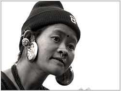
A Limbu woman
|
|
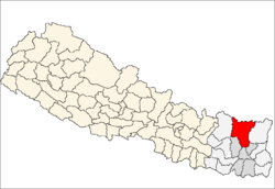
 Location of Sankhuwasabha |
|
| Country | Nepal |
| Region | Eastern (Purwanchal) |
| Zone | Kosi |
| Headquarters | Khandbari |
| Area | |
| • Total | 3,480 km2 (1,340 sq mi) |
| Population (2011) | |
| • Total | 158,742 |
| • Density | 46/km2 (120/sq mi) |
| Time zone | NPT (UTC+5:45) |
| Website | ddcsankhuwasabha |
Sankhuwasabha District (Nepali: सङ्खुवासभा जिल्ला ![]() Listen (help·info)) is in Kosi Zone of Nepal's Eastern Development Region. The district's area is 3,480 km² with a population of 159,203 in 2001 and 158,742 in 2011. The administrative center is Khandbari.Newly Register Municipality in this district are Chainpur and Madi.
Listen (help·info)) is in Kosi Zone of Nepal's Eastern Development Region. The district's area is 3,480 km² with a population of 159,203 in 2001 and 158,742 in 2011. The administrative center is Khandbari.Newly Register Municipality in this district are Chainpur and Madi.
Bordering districts are Bhojpur, Terhathum and Dhankuta in Koshi Zone; Solukhumbu in Sagarmatha Zone; and Taplejung in Mechi Zone. Tingri County of Shigatse Prefecture in the Tibet Autonomous Region of China borders to the north.
Indigenous janajati ethnics are Kumal, Yakkha, Lohorung, Kulung, Rai, Gurung, Limbu, and other hill castes (e.g. Chhetri, Bahun) and ethnic groups (e.g. Newar, Sherpa) live in this district. Kumals are concentrated in Tumlingtar.
The district is also known for cardamom farming.
Contents
Geography and climate[edit]
| Climate Zone[1] | Elevation Range | % of Area |
|---|---|---|
| Lower Tropical | below 300 meters (1,000 ft) | 0.3% |
| Upper Tropical | 300 to 1,000 meters 1,000 to 3,300 ft. |
10.0% |
| Subtropical | 1,000 to 2,000 meters 3,300 to 6,600 ft. |
24.8% |
| Temperate | 2,000 to 3,000 meters 6,400 to 9,800 ft. |
23.3% |
| Subalpine | 3,000 to 4,000 meters 9,800 to 13,100 ft. |
12.8% |
| Alpine | 4,000 to 5,000 meters 13,100 to 16,400 ft. |
8.4% |
| Nival | above 5,000 meters | 20.4% |
The Arun River enters from Tibet at an elevation of about 3,500 meters (11,500 feet) and flows south across the district, forming one of the world's deepest valleys relative to 8,481 meter Makalu to the west and 8,586 meter Kangchenjunga to the east.
Village Development Committees (VDCs) and Khandbari Municipality[edit]
Aankhibhui, Bahrabise, Bala, Baneswor, Chainpur, Chepuwa, Dhupu, Diding, Hatiya, Jaljala, Kharang, Madi Mulkharka, Madi Rambeni, Makalu, Mamling, Mangtewa, Matsya Pokhari, Mawadin, Num, Nundhaki, Pangma, Sekaha, Pathibhara, Pawakhola, Savapokhari, Siddhakali, Siddhapokhari, Sisuwa, Sitalpati, Syabun, Tamafok, Tamphu, Yaphu, Wana
List of medicinal herbs[edit]
- Yarchagumba (Nepali: यार्शागुम्बा; yārshāgumbā)
- adamchal
- akhanbed
- Picrorhiza kurroa (Nepali: कुट्की; kuTkī)
- Spikenard (Nepali: जटामसि; jaTāmasi)
- Astilbe rivularis (Nepali: ठुलो ओखति; Thulo okhati)
- Yellow myrobalan (Nepali: हर्रो; harro)
- Indian gooseberry (Nepali: अमला; amalā)
- Khanappa
- Mistletoe (Nepali: हडचुर; haRchur)
- Sichuan pepper (Nepali: टिमुर; Timur)
- Monkshood (Nepali: बिख्मा, bikhmā)
- Cardamom (Nepali: अलैँचि; alainchi)
- Gentian (Nepali: चिरैतो; chiraito)
- Pepper (Nepali: चाबो; chābo)
- Ipla
- Calamus (Nepali: बोझो; bojho)
- Bis Jara
Hinwa Wine[edit]
The district of Sankhuwasabha is famous in Nepal for the production of Hinwa wine. This wine has a huge market in the eastern cities of Biratnagar and Dharan and also in the capital city of Kathmandu.
See also[edit]
References[edit]
- ^ The Map of Potential Vegetation of Nepal - a forestry/agroecological/biodiversity classification system (PDF), . Forest & Landscape Development and Environment Series 2-2005 and CFC-TIS Document Series No.110., 2005, ISBN 87-7803-210-9, retrieved Nov 22, 2013 horizontal tab character in
|series=at position 91 (help)
External links[edit]
- Districts of Nepal at statoids.com
- "Sankhuwasabha District". Sankhuwasabha.com. Retrieved 4 January 2013.
Coordinates: 27°22′N 87°13′E / 27.367°N 87.217°E
| This Nepalese location article is a stub. You can help Wikipedia by expanding it. |

