Australian Weather

National Summary
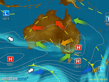
A low pressure trough in the west is causing areas of rain and storms, some severe. A low pressure trough in the east is also triggering showers and storms. Onshore winds along the QLD coast are producing showers. A cold front is bringing a gusty cool change to TAS.
State Weather
Click for state forecasts


Weather News
Several stormy days in northeast NSW
14:44 EST
The last few days have been quite stormy in northeastern parts of NSW, with this daily occurrence set to continue.
Tasmania belted as cold front approaches
10:46 EST
Parts of the Apple Isle have been buffeted by wind gusts exceeding 100km/h.
Darwin's sizzling April
13:38 EST
With a run of hot and sunny days ahead, Darwin shows no signs of cooling off.


Extremes and Records
| Current Extremes | Last 3 Days Extremes | Extremes This Month | |||
|---|---|---|---|---|---|
| Fri 08/04 | Sat 09/04 | Sun 10/04 | |||
|
35.2°C Marble Bar, WA |
Hottest |
42.6°C Mandora, WA |
41.4°C Marble Bar, WA |
43.0°C Mandora, WA |
48.1°C Minnipa, SA |
|
2.9°C Mt Wellington, Tas |
Coldest |
-2.6°C Perisher Valley, NSW/ACT |
-1.0°C Thredbo Village, NSW/ACT |
-2.6°C Perisher Valley, NSW/ACT |
|
|
WNW 83km/h Maatsuyker Is, Tas |
Windiest |
98km/h Maatsuyker Is, Tas |
129km/h Maatsuyker Is, Tas |
133km/h Mt Wellington, Tas |
- |
| no rain last hr | Wettest |
41.0mm Mt Read, Tas |
66.0mm Christmas Island Ap, WA |
96.0mm Coldstream, Vic |
|
| Australia's Records for April | |||
|---|---|---|---|
| Max | Min | Rain | |
| Highest 45.0°C at Marble Bar, WA in 1928 Lowest -5.6°C at Thredbo Top Station, NSW/ACT in 1978 |
Highest 32.0°C at Pannawonica, WA in 1981 Lowest -17.4°C at Mt Hotham, Vic in 1991 |
Highest 800.9mm at Port Douglas, Qld in 1911 |
|
-
Display your Local Weather here
automatically each time you visit us:

Rotates through Temperature,
Wind, Humidity and RainUse the Search Bar above
to find your Local, and go to the Local page
Click "Set My Local"
button next to the location name


