Canberra Weather Today

  • Print Print page
  • Email Email this
  • Permalink Permalink
  • Share this:
    Share

Current Conditions

  • 22.4°
    in Canberra
  • Wind: N at 15.0kph
  • Humidity: 52%
  • Sunrise: 6:00am AEDT
  • Sunset: 7:34pm AEDT

Canberra Weather - 7 Day Forecast

    • Today

    • Thunderstorms
    • Thunderstorms
    • 10° min26°
    • Wind (km/h)

      • am

        9
        NW
      • pm

        11
        NW
    • Humidity

      • am

        78%
      • pm

        60%
    • UV Index

      Very High (10)
    • Chance of rain

      90% 20-40mm
    • Frost risk

      Nil
    • Tomorrow

    • Clearing shower
    • Clearing shower
    • 13° min26°
    • Wind (km/h)

      • am

        13
        WNW
      • pm

        24
        WNW
    • Humidity

      • am

        80%
      • pm

        45%
    • UV Index

      Very High (10)
    • Chance of rain

      70% < 1mm
    • Frost risk

      Nil
    • Tuesday

    • Late shower
    • Late shower
    • 10° min19°
    • Wind (km/h)

      • am

        8
        E
      • pm

        19
        NE
    • Humidity

      • am

        79%
      • pm

        74%
    • UV Index

      Very High (10)
    • Chance of rain

      90% 10-20mm
    • Frost risk

      Nil
    • Wednesday

    • Rain developing
    • Rain developing
    • 12° min18°
    • Wind (km/h)

      • am

        9
        NNE
      • pm

        22
        NNW
    • Humidity

      • am

        89%
      • pm

        97%
    • UV Index

      Very High (10)
    • Chance of rain

      90% 20-40mm
    • Frost risk

      Nil
    • Thursday

    • Showers
    • Showers
    • 12° min22°
    • Wind (km/h)

      • am

        10
        NW
      • pm

        22
        WNW
    • Humidity

      • am

        87%
      • pm

        69%
    • UV Index

    • Chance of rain

      90% 5-10mm
    • Frost risk

      Nil
    • Friday

    • Possible shower
    • Possible shower
    • 11° min25°
    • Wind (km/h)

      • am

        9
        SE
      • pm

        21
        WNW
    • Humidity

      • am

        80%
      • pm

        56%
    • UV Index

    • Chance of rain

      70% 1-5mm
    • Frost risk

      Nil
    • Saturday

    • Possible shower
    • Possible shower
    • 10° min21°
    • Wind (km/h)

      • am

        7
        ESE
      • pm

        22
        ESE
    • Humidity

      • am

        76%
      • pm

        59%
    • UV Index

    • Chance of rain

      70% < 1mm
    • Frost risk

      Nil

Synoptic chart

Sunday - 5:00pm EST Todays Synoptic weather chart

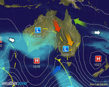
Low pressure troughs are generating severe thunderstorms in QLD, NSW and VIC, mainly inland. A trough in the west is triggering a few storms inland. A front is bringing showers and a colder change to TAS. Highs are keeping much of SA and eastern QLD dry. More Synoptic information

Satellite Photo

Sun - 6:00 pm EDT Satellite image for NSW

Areas of thick cloud across NSW in a deep low pressure trough is generating showers and thunderstorms, some severe. Thunderstorms are heaviest and most widespread on and west of the ranges. Wispy jetstream cloud over the far northeast is bringing no rain.

Unless otherwise indicated weather content is supplied by Weatherzone.

Warnings

Last updated 01 Nov 2015 6:51pm AEDT
Warning
  • Flood warning

    Issued at 2:30pm on Sunday 01 November 2015

    Flood Watch for the Belubula River and the Bell River at Wellington

  • Severe thunderstorm warning

    Issued at 6:26pm on Sunday 01 November 2015

    Severe Storm Warning (Damaging Wind & Large Hail) SW & CW Slopes/Plains, Southern Tablelands, Riverina, Upper/Lower Western & Snowy Mts

  • Full warnings

Weather Submissions

Submit a weather photo


Having Trouble?

Our previous Contribute Upload page is still avaliable.