Canadian Rockies AWG Field Trip – A Summary

The AWG 2014 Canadian Rockies Field Trip took place from August 28 to September 7, 2014, with a Calgary-area geology pre-trip for early arrivals on August 27.  The main part of the field trip commenced with a mid-morning departure on the 28th from Calgary, and we all headed west along Canada Highway 1 to Lake Louise. After spending two days in the Lake Louise area, we drove north to the Columbia Icefields. A few of us continued further north the next day, on an side trip to Jasper. From the Icefields we toured south to Field, British Columbia, over to Revelstoke, and ended our British Columbia time in Fernie. We then drove east, back into Alberta, and spent time at Dinosaur Provincial Park near Brooks and at the Royal Tyrrell Museum of Palaeontology in Drumheller. The trip ended with our group once more back in Calgary, Alberta.

There were 22 people as full-time field-trippers and two more people on the trip during the Icefields to Field, B.C. part of the trip. Two of the full-time trip participants were students and one of the additional, part-time trip participants, was a student. All of the students on the field trip are from Mount Royal University in Calgary and are students of our field trip leader, Katherine Boggs. Paul Hoffman and Mindy Brugman also helped out for a day or so during the trip. Marcia Knadle and Debra Hanneman did the trip budget and logistics. We had a great field trip guidebook, thanks largely to Katherine Boggs’ efforts. The field trip guidebook, “Tectonics, Climate Change, and Evolution: Southern Canadian Cordillera” will be on sale at the AWG online store soon.

Some of us took to the water and canoed around Moraine Lake near Lake Louise, Alberta. Moraine Lake is located within the valley known as the “Valley of the Ten Peaks” which was once featured on the Canadian twenty dollar bill.

Some of us took to the water and canoed around Moraine Lake near Lake Louise, Alberta. Moraine Lake is located within the valley known as the “Valley of the Ten Peaks” which was once featured on the Canadian twenty dollar bill.

Katherine Boggs talks to the field trip crew about area geology at a stop along the Icefields Parkway in Alberta.

Katherine Boggs talks to the field trip crew about area geology at a stop along the Icefields Parkway in Alberta.

Our intrepid field crew hikes the Athabasca Glacier, one of the six major glaciers of the Columbia Icefield.

Our intrepid field crew hikes the Athabasca Glacier, one of the six major glaciers of the Columbia Icefield.

Paul Hoffman explains features of the Neoproterozoic Old Fort Point Formation near Jasper, Alberta.

Paul Hoffman explains features of the Neoproterozoic Old Fort Point Formation near Jasper, Alberta.

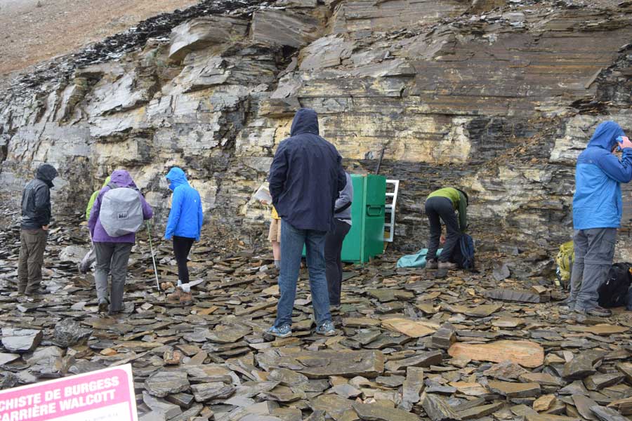
Some of the field trip group took the arduous hike up to the famous Walcott Quarry that is developed within the Cambrian Burgess Shale near Field, British Columbia.

Some of the field trip group took the arduous hike up to the famous Walcott Quarry that is developed within the Cambrian Burgess Shale near Field, British Columbia.

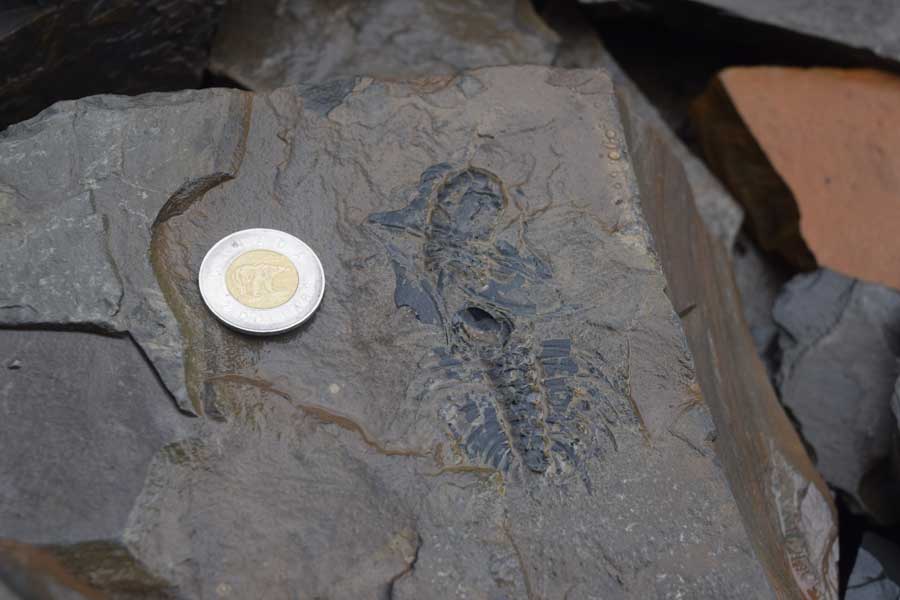
A member of our field trip group shows us one of the Burgess Shale’s trilobites from the Walcott Quarry.

A member of our field trip group shows us one of the Burgess Shale’s trilobites while at the Walcott Quarry.

One of the trip’s frequent rainy days – but we still had fun by the Kicking Horse River at its confluence with the Columbia River, near Golden, British Columbia.

One of the trip’s frequent rainy days – but we still had fun by the Kicking Horse River at its confluence with the Columbia River, near Golden, British Columbia.

Our field trip group poses by Columbia Lake, which forms the headwaters for both the Columbia and Kootenay rivers, and lies within the enigmatic Rocky Mountain Trench near Canal Flats, British Columbia.

Our field trip group poses by Columbia Lake, which forms the headwaters for both the Columbia and Kootenay rivers, and lies within the enigmatic Rocky Mountain Trench near Canal Flats, British Columbia.

The Frank Slide was a must-stop as we drove along the Crowsnest Highway near Blairmore, Alberta. The slide happened on April 29, 1903, when about 82 million tons of limestone fell off of Turtle Mountain.

The Frank Slide was a must-stop as we drove along the Crowsnest Highway near Blairmore, Alberta. The slide happened on April 29, 1903, when about 82 million tons of limestone fell off of Turtle Mountain.

Part of our field trip group discusses Centrosaur Bone Bed 43 during our guided hike at Dinosaur Provincial Park, Alberta.

Part of our field trip group discusses Centrosaur Bone Bed 43 during our guided hike at Dinosaur Provincial Park, Alberta.

Notes From the Field – The Rest of the 2014 AWG Geology Field Trip

The 2014 AWG Canadian Rockies Geology Field Trip did actually end last Sunday (9/7) and we did indeed make it back to Calgary largely unscathed. As many of you probably know, when lodging amenities state that WiFi is included, it most likely means that one can check email – not post blogs with photos of any size, or maybe not even post blogs without photos. Anyways, we did run out of somewhat viable WiFi in our remaining travels. So – this blog is a brief summary of what other adventures awaited us on the road from Revelstoke, B.C. to Fernie, B.C., and then eastward to Dinosaur Provincial Park near Brooks, Alberta, and finally to the amazing Royal Tyrrell Museum at Drumheller, Alberta.

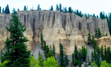
Dutch Creek Hoodoos at mouth of Dutch Creek along Highway 93/95 south to Cranbrook, B.C.. The hoodoos are calcite-cemented Quaternary deltaic foresets deposited at edge of Glacial Lake Invermere.

Dutch Creek Hoodoos at mouth of Dutch Creek along Highway 93/95 south to Cranbrook, B.C.. The hoodoos are calcite-cemented Quaternary deltaic foresets deposited at edge of Glacial Lake Invermere.


View southeastward of the Rocky Mountain Trench along Highway 93/95 South where Columbia Lake forms the headwaters to both the Columbia and Kootenay Rivers.

View southeastward of the Rocky Mountain Trench along Highway 93/95 South where Columbia Lake forms the headwaters to both the Columbia and Kootenay Rivers.


The Three Sisters as viewed from Fernie, B.C.. All the rock units are upside down, with the Devonian Palliser Formation comprising the top of the far left "sister" and the Mississippian Rundle Formation overlying the Triassic Spray River Group (in the lower right of photo and occurring mostly in tree-covered slopes) via the Hosmer Thrust.

The Three Sisters as viewed from Fernie, B.C.. All the rock units are upside down, with the Devonian Palliser Formation comprising the top of the far left “sister” and the Mississippian Rundle Formation overlying the Triassic Spray River Group (in the lower right of photo and occurring mostly in tree-covered slopes) via the Hosmer Thrust.


The Frank Slide, located east of the towns of Coleman and Blairmore, Alberta, in the Crowsnest Pass area. The slide occurred on 4/29/1903. when 82 million tons of limestone fell off Turtle Mountain, burying part of the town of Frank, Alberta.

The Frank Slide, located east of the towns of Coleman and Blairmore, Alberta, in the Crowsnest Pass area. The slide occurred on 4/29/1903. when 82 million tons of limestone fell off Turtle Mountain, burying part of the town of Frank, Alberta.


Dinosaur Provincial Park near Brooks, Alberta - the darker colored unit, the Dinosaur Park Formation sits atop the lighter colored, Oldman Formation. Both units are placed within the Cretaceous (Campanian) Belly River Group.

Dinosaur Provincial Park near Brooks, Alberta – the darker colored unit, the Dinosaur Park Formation sits atop the lighter colored, Oldman Formation. Both units are placed within the Cretaceous (Campanian) Belly River Group.


Centrosaur bone bed located near the central part of Dinosaur Provincial Park. Our group had an amazing guided tour to this bone bed which occurs in the Dinosaur Park Formation.

Centrosaur bone bed located near the central part of Dinosaur Provincial Park. Our group had an amazing guided tour to this bone bed which occurs in the Dinosaur Park Formation.


Finally - the Royal Tyrrell Museum at Drumheller, Alberta. The museum has fantastic displays, and of course I spent much time in their Burgess Shale faunal reconstruction display!

Finally – the Royal Tyrrell Museum at Drumheller, Alberta. The museum has fantastic displays, and of course I spent much time in their Burgess Shale faunal reconstruction display!


Notes From The Field – Revelstoke to the Okanagan

Finally we had a mostly sunny day! We began the day with a tour of the Revelstoke Dam. This dam was one of the last Canadian dams built within the Columbia River watershed. The dam area is really interesting because just across the highway from the dam is the Columbia River Fault zone – a Early to Middle Eocene crustal-scale, east-dipping, extensional fault zone that follows the Columbia River Valley near Revelstoke. Now that was a bit disconcerting for me as I looked at the zone while standing on the top of the dam structure. Our group split up after the dam tour, and I went with the group to the Okanagan Valley. Among our stops were: 1. Three Valley Lake for a look at the hanging wall of the Monashee decollment, Craigellachie, where the last spike of the Canadian Pacific Railway was set in 1885, and the Okanagan-Eagle River Fault zone. Below are some of the day’s photos….

Revelstoke Dam spillway

Revelstoke Dam spillway


Mass wasting in rocks cut by the Columbia River Fault Zone near the Revelstoke Dam.


Rocks of the Three Valley assemblage – pelitic gneisses and mica schists – are cut by mafic dikes.

The last spike cairn at Craigellachie.

The last spike cairn at Craigellachie. Note the coal train in the background going by the cairn.


Quest for the Eagle River fault zone.


Notes From The Field – Lake Louise and Moraine Lake

I’m backtracking somewhat here by posting on our trips to both Lake Louise and Moraine Lake. Both are so gorgeous that I didn’t want to exclude them from the postings, but my SD card with their photos was not accessible when I did the initial postings. Suffice it to say that hikes and canoeing in these areas was great. The sun broke through long enough that afternoon that we had a very pleasant time at Lake Louise. We arrived at Moraine Lake in the morning so we could get there before the parking lot filled and we were greeted by heavy mist just starting to lift off the lake. Here are photos of both areas:

Lake Louise is a glacial cirque lake dammed by a recessional moraine.

Lake Louise is a glacial cirque lake dammed by a recessional moraine.

Moraine Lake lies in the Valley of the Ten Peaks - a scene that was once featured on the Canadian twenty dollar bill.

Moraine Lake lies in the Valley of the Ten Peaks – a scene that was once featured on the Canadian twenty dollar bill.

Skolithos, a trace fossil with the form of vertical burrows, is found in the Cambrian Gog quartzite present in this area.

Skolithos, a trace fossil with the form of vertical burrows, is found in the Cambrian Gog quartzite present in this area.

The “Rockpile” near the parking lot at Moraine Lake. Great views are to be had – if it is not raining.

Discussion time near Laggan's Mountain Bakery , Lake Louise.

Discussion time near Laggan’s Mountain Bakery , Lake Louise.

Notes From The Field – Field, B.C. to Revelstoke, B.C.

The AWG field trip continued along the Trans-Canadian Highway 1 from Field, B.C. to Revelstoke, B.C. – again in the rain. But at least the rain stopped several times for us to have fun at our trip stops. We followed the Kicking Horse River to its junction with the mighty Columbia River at Golden, B.C.. We had our first look at the Rocky Mountain Trench – we could sort of see it through the mist at an overlook near Golden. Then up over Roger’s Pass and into Revelstoke brought us to the day’s end. As can be seen in the photos below, we had alot of fun at the meeting of the Columbia and Kicking Horse waters….

Delta complex exposed at side of Kicking Horse River near Golden - note the large-scale cross-beds.

Delta complex exposed at side of Kicking Horse River near Golden – note the large-scale cross-beds.

Nora - one of our intrepid AWG field trippers- points out at side channel of the Kicking Horse River near its confluence with the Columbia River.

Nora – one of our intrepid AWG field trippers- points out a side channel of the Kicking Horse River near its confluence with the Columbia River.

The confluence of the Columbia and Kicking Horse rivers near Golden, B.C.. Note the differnt water colors as the Kicking Horse River flows in from the right side of the photo to mix with the Columbia waters.

The confluence of the Columbia and Kicking Horse rivers near Golden, B.C.. Note the different water colors as the Kicking Horse River flows in from the right side of the photo to mix with the Columbia waters.

Again at the Columbia/Kicking Horse rivers confluence. We couldn't pass  up a skipping stone contest...

Again at the Columbia/Kicking Horse rivers confluence. We couldn’t pass up a skipping stone contest….

Heather Hill debris flow near Roger's Pass on the Trans-Canadian Highway 1.

Heather Hill debris flow near Roger’s Pass on the Trans-Canadian Highway 1.

Notes From The Field – The Burgess Shale Hike

The hike to the famous Walcott Quarry in the Burgess Shale near Field, British Columbia, was one of my highlights of the AWG field trip.The hike was long and seemed to go on forever – especially the climb up to the quarry. It was in total about 11 km into the quarry and then 11 km out. And of course it was raining, and this time a bit of sleet and snow was added to the mix just to keep life interesting. But it was well worth it just to see the setting where the Cambrian Burgess Shale fauna comes from. Again, I’ll dispense with words, and go right to the views.

The start of the hike.

The start of the hike.

View from the Burgess Shale hike trail.

View from the Burgess Shale hike trail.

emerald.lake

Emerald Lake as seen from the hiking trail.

The Walcott Quarry.

The Walcott Quarry.

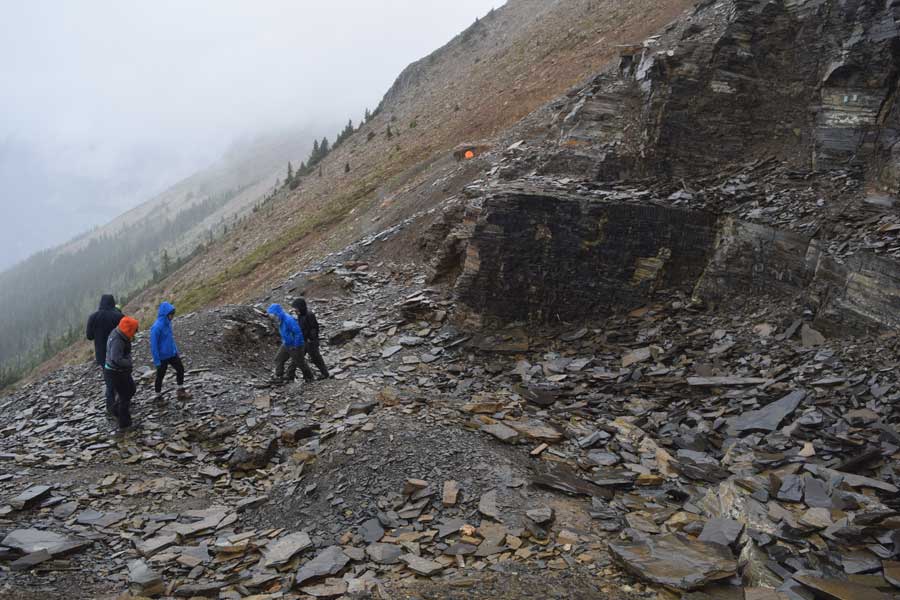
The Walcott Quarry - another view.

The Walcott Quarry – another view.

A trilobite found just below the quarry.

A trilobite found just below the quarry.

Sidneyia - an extinct arthropod from the quarry workings.

Sidneyia – an extinct arthropod from the quarry workings.

Notes From The Field – Icefields Parkway

After more rain and no wifi, we’re finally in Revelstoke, British Columbia where we still have rain, but finally have some wifi. We had a great trip from Lake Louise (I will post a few photos of scenes from Lake Louise later as my camera flash card for that part of the trip is still in my truck) up the Icefields Parkway to the Athabaska Glacier. Most of us ended up staying at Hostel International’s Rampart Creek Hostel for the night. If ever traveling up the Parkway, I do recommend staying at Rampart – Ken is a wonderful host and the setting is marvelous. Anyways, here are a few of the spectacular scenes that we saw…..

Crowfoot Glacier.

Crowfoot Glacier.


Lower Paleozoic rocks of the Parkway.

Lower Paleozoic rocks of the Parkway.

Mazama and Bridge River volcanic ashes exposed in bank cut near Saskatchewan Crossings.

Mazama and Bridge River volcanic ashes exposed in bank cut near Saskatchewan Crossings.

The toe of the Athabaska Glacier.

The toe of the Athabaska Glacier.

Notes From The Field

The first full day of the AWG Canadian Rockies Field Trip opened to pouring rain by the time we reached the Canmore, Alberta area – about 66 miles west of Calgary. So no grand views of the impending Front Ranges or sights of Triangle Zone structure. Once in a while during lunch we could vaguely see the break in slope that marks the McConnell Thrust at Mount Yamnuska. But even in the downpour, our intrepid leader Katherine Boggs got us out of the vehicles to look at and talk about the Kananaskis Dam and its geology.

Pouring rain does not deter the AWG field trip discussions.

Pouring rain does not deter the AWG field trip discussions.

The Upper Cretaceous Cardium Formation is the bedrock at the dam. Extensional faulting – late Cretaceous/Paleocene in age and expressed as a series of grabens and horsts – cuts the Cardium at the dam site. I took a long look at those structures knowing that that’s probably the last I’ll see of extensional faulting for awhile.

Extensional faulting in the Upper Cretaceous Cardium Formation at the Kananaskis Dam near Canmore, Alberta.


The downpour started to break a few miles east of Lake Louise. It was really spectacular to see the clouds begin to part around Castle Mountain. The Castle Mountain Thrust is at the base of the mountain and it delineates the boundary between the Front Ranges and the Eastern Main Ranges. Flat-lying Cambrian carbonates comprise Castle Mountain as opposed to generally west-dipping Devonian/Mississippian carbonates of the Front Ranges The weather forecast sounds better for tomorrow… we’ll see. Tomorrow brings hikes around the Lake Louise-Moraine Lake areas, so some clear skies would be welcome.

Castle Mountain finally breaks through the clouds.

AWG 2014 Canadian Rockies Geology Field Trip Gears Up

Castle Mountain (Canadian Main Ranges) and Bow River, Banff National Park, Alberta, by Ben Rye.

Castle Mountain (Canadian Main Ranges) and Bow River, Banff National Park, Alberta, by Ben Rye.

The Association for Women Geoscientists’ 2014 Canadian Rockies geology field trip is fast approaching. The trip starts and ends in Calgary, and runs from August 28th through September 7th, with pre-trip hikes around the Calgary area on August 27th. Because the trip geology will be so spectacular and many people wanted to go, but just did not have the available time to do so, we decided that we will do blog postings during the trip whenever we have access to wifi (which should be most of the field trip nights). And – if anyone is really interested in the trip after following our travels, the field guidebook will be on sale at the AWG Online store after the trip.

To better follow our postings, I thought it would be helpful to give a brief run-down of the trip itinerary so that everyone knows what to expect for our travels:

August 27thFish Creek Park in Calgary – looking at the 2005 and 2013 Calgary flood features and constraining the boundary between the Laurentian and Cordilleran Ice Sheets.

August 28th and 29th – Trans-Canada Highway to Lake Louise for classic transect through Foothills to Main Ranges of Foreland Fold and Thrust Belt.

August 30th and August 31st – Icefields Parkway: Peyto Lake, Saskatchewan Glacier, Athabasca Glacier stops just to name a few. We also will have Paul Hoffman with us, so we will have good discussions on topics like “snowball earth”.

September 1st – Field, B.C. area with Burgess Shale Hike or other options such as Iceline Trail hike,Takakkaw Falls.

September 2nd  and 3rd - Revelstoke – Rocky Mountain Trench to Omineca Crystalline Belt, Roger’s Pass, Illicillewaet Glacier hike.

September 4th – Rocky Mountain Trench to Fernie – Windermere Supergroup (Rodinia breakup, turbidites discussions).

September 5thCrowsnest Pass to Dinosaur Provincial Park (Crowsnest duplexes & Lewis Thrust; Crowsnest Volcanics; Frank Slide).

September 6thDinosaur Provincial Park: hiking in the Badlands and guided tour of DPP bone beds.

September 7th – Dinosaur Provincial Park to Tyrrell Museum at Drumheller and return to Calgary.

Prospecting For Vertebrate Fossils On Hot Summer Days In Southwestern Montana

The end of July always brings The Webb School students who are interested in paleontology to southwestern Montana. That time is packed with prospecting a variety of Tertiary sites in the hopes of finding interesting vertebrate fossils. This year had its good finds along with persevering through some really hot days. Being on a surface of light-colored rocks under the intense sun while slowly looking for fossils such as rodent jaws, rabbit teeth, or even isolated horse teeth is a tough way to spend a summer day. Even prospecting for larger pieces of fossil vertebrates is no easy day, but the students hung in there. Here’s a few scenes from the prospecting adventures:

The late Eocene strata at Pipestone held the students attention for many hours

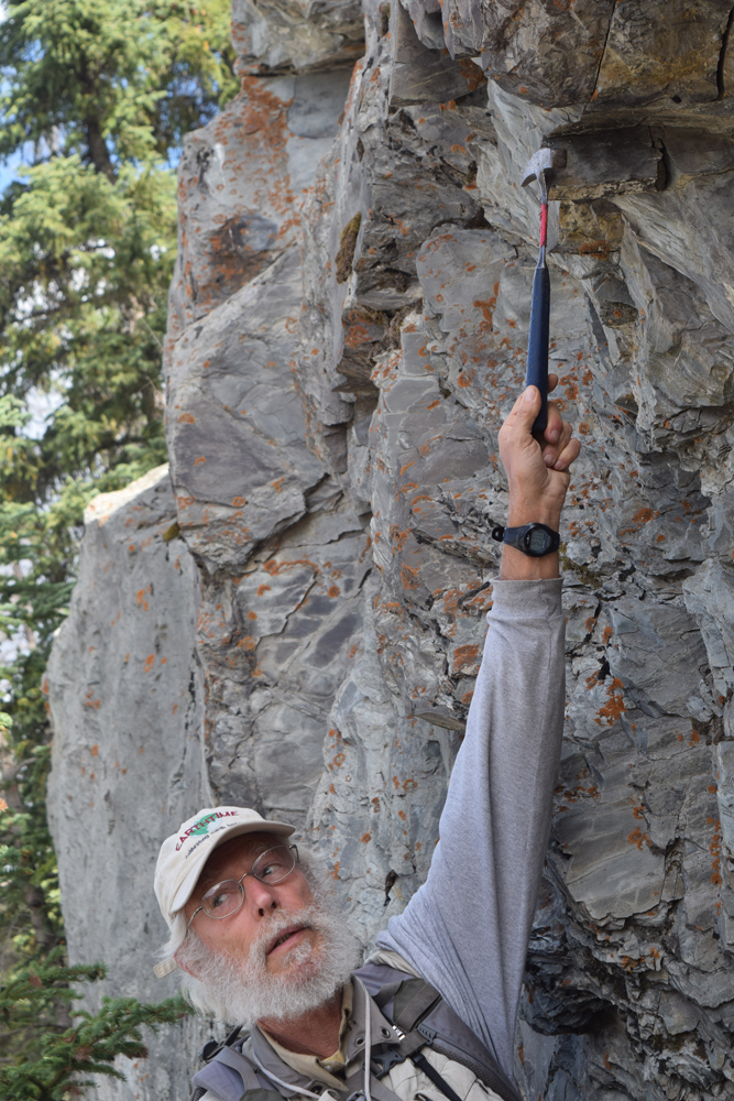
The late Eocene strata in the Pipestone area west of Whitehall held the students attention for many hours.


Late Tertiary outcrops north of Whitehall, Montana, yielded some interesting horse and camel remains.

Late Tertiary outcrops north of Whitehall, Montana, yielded some interesting horse and camel fossils.


A horse jaw and at least part of the skull was found in late Tertiary strata.

A horse jaw and at least part of the skull were found in late Tertiary strata located near Whitehall.


Still searching for that elusive fossil....

Still searching for that elusive fossil in the North Boulder Valley….


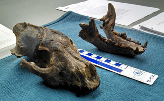
Late Tertiary canid dog skull fossil find from last season's Webb School  paleo students' efforts. Skull is now at the Museum of the Rockies.

Late Tertiary canid dog skull fossil find from last season’s Webb School paleo students’ efforts. The skull is now at the Museum of the Rockies in Bozeman, Montana.


For those truly interested in vertebrate paleontology, keep in mind that the renowned Raymond Alf Museum is also on the Webb Schools campus. The museum is definetly worth a visit.