-
Weather
Australia
- National
- New South Wales
- Victoria
- Queensland
- Western Australia
- South Australia
- Tasmania
- ACT
- Northern Territory
Long Range Forecasts
Lifestyle
- Radar & Maps
- Marine
- Agriculture
-
Surf & Snow
Surfing
Snow & Ski
-
Climate
Climate Indicators
- Services
- Shop
Australian Weather
- map
- temperature
- satellite
- radar/lightning
- synoptic
 navigate by state
 current extremes
Hottest
Narrabri Ap, NSW/ACT
45.6°C
Coldest
Mt Read, Tas
4.7°C
Windiest
Cape Grim, Tas
W 66km/h
Wettest
Luncheon Hill, Tas
0.4mm last hr
 current national summary
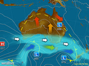
A broad low pressure trough is triggering potentially severe thunderstorms in QLD. Very hot northwesterly winds are filtering into QLD ahead of this trough. A cold front is bringing a gusty change for TAS and VIC. A building high pressure ridge is keeping the southwest dry.
 capital cities
| Sydney | 20°C | 26°C | |
| Melbourne | 14°C | 21°C | |
| Brisbane | 25°C | 41°C | |
| Perth | 15°C | 29°C | |
| Adelaide | 15°C | 22°C | |
| Canberra | 13°C | 26°C | |
| Hobart | 11°C | 19°C | |
| Darwin | 26°C | 34°C |
 most recent warnings
Qld - Fri 17:19 ESTSevere Thunderstorm Warning
Qld - Fri 17:14 EST
Severe Thunderstorm Warning
NSW/ACT - Fri 17:56 EDT
Severe Thunderstorm Warning
View all current warnings

Put Weather on Your Site!
Weatherzone offers many ways to get weather on your site
Enter a postcode or town name for local weather, or text to search the site.
» advanced search

Heatwave hits inland Australia: scorching temperatures tipped to break, bringing relief
17:58 EDT
Experts are predicting a return to average temperatures in inland areas by the weekend, bringing relief to regions that have been sweltering in record-breaking temperatures.
Help with Weatherzone


