


3:38

Geographic Coordinate System : geoid and spheroid concept : Part - 1
My first video......lot of errors......incomplete......bt still wanted to load......improv...
published: 13 Feb 2011
Author: MultiVincere
Geographic Coordinate System : geoid and spheroid concept : Part - 1
My first video......lot of errors......incomplete......bt still wanted to load......improved version will soon be there......
0:36

Coordinate Systems: Latitude and Longitude
This animation illustrates that standard way of describing a location on the earth's s...
published: 04 Jul 2010
Author: mrg3
Coordinate Systems: Latitude and Longitude
This animation illustrates that standard way of describing a location on the earth's spherical surface using latitude and longitude. The zero points for these coordinates arise from the rotation of the earth (a physical phenomena which determines the north and south poles and the equator) and Greenwich, England (a historical/political choice).
10:42

ArcGIS - Introduction to Geographic Information System - Chapter 2 - Coordinate System
Introduction to Geographic Information Systems, 5e is designed to provide students in a fi...
published: 02 Sep 2010
Author: jacketphish
ArcGIS - Introduction to Geographic Information System - Chapter 2 - Coordinate System
Introduction to Geographic Information Systems, 5e is designed to provide students in a first or second GIS course with a solid foundation in both GIS concepts and the use of GIS. Introduction to GIS strikes a careful balance between GIS concepts and hands-on applications. The main portion of the chapter presents GIS terms and concepts and helps students learn how each one fits into a complete GIS system. At the end of each chapter, an application section with 2-7 tasks presents students with actual GIS exercises and the necessary data to solve the problem. Key features This edition has combined georelational and object-based vector data models into one chapter. A couple of years ago the majority of GIS users were still using georelational vector data such as shapefiles. But now many have turned to object-based vector data such as the geodatabase. Therefore it makes sense to combine these two data models into a chapter and simply call the chapter vector data model. New and updated information on: Joins, relates, and relationship classes (Chapter 8) Cartographic representation (Chapter 9) Point pattern analysis (Chapter 11) Viewshed analysis (Chapter 14) v Geocoding (Chapter 15) About the author Kang-tsung Chang Karl Chang is a professor at the University of Idaho. Table of contents 1 Introduction 2 Coordinate Systems 3 Vector Data Model 4 Raster Data Model 5 GIS Data Acquisition 6 Geometric Transformation 7 Spatial Data Editing 8 Attribute Data Management 9 Data Display <b>...</b>
1:50

Plex.Mark! - Use your coordinate systems in Google Earth
This video tutorial shows how to use Plex.Mark! (the free plug-in by Plexscape) and work w...
published: 28 May 2009
Author: plexscape
Plex.Mark! - Use your coordinate systems in Google Earth
This video tutorial shows how to use Plex.Mark! (the free plug-in by Plexscape) and work with your coordinate systems in Google Earth. More info & download: www.plexscape.com
1:53

How to define geographic coordinate of a point.wmv
Geographic coordinates of a point can be defined in terms of lattitude and longitude which...
published: 28 Sep 2011
Author: vikas2708
How to define geographic coordinate of a point.wmv
Geographic coordinates of a point can be defined in terms of lattitude and longitude which is described in this video....
6:32

Casio fx9860G Geographic to Grid Coordinates
Using big shots land survey program in casio fx9860g to convert geographic (latitude and l...
published: 06 Jan 2010
Author: bigshots1995
Casio fx9860G Geographic to Grid Coordinates
Using big shots land survey program in casio fx9860g to convert geographic (latitude and longitude) coordinates to grid coordinates in PTM, UTM, or WGS84. Developed by Engr. Bert Recamunda
0:51

Geographical Coordinates
Geographical coordinates for products and suburbs can now accept decimal values. Labels fo...
published: 01 Nov 2011
Author: RespaxSoftware
Geographical Coordinates
Geographical coordinates for products and suburbs can now accept decimal values. Labels for the X and Y coordinates are now labelled Longitude and Latitude as this is the most common geographical coordinate system. Note that this is a decimal amount and not degrees, minutes and seconds.
5:17

Geography Movie: Latitude and Longitude
First movie I made so it's quite sloppy, but it takes pupils through the major lines o...
published: 21 Jun 2007
Author: rebeccadimmick
Geography Movie: Latitude and Longitude
First movie I made so it's quite sloppy, but it takes pupils through the major lines of latitude and longitude to an overly dramatic music score.
2:27

Managing Drawings with different Coordinate systems
The contours reside in latitude-longitude coordinates, and the parcels are in the Californ...
published: 18 Sep 2011
Author: Leoparra04
Managing Drawings with different Coordinate systems
The contours reside in latitude-longitude coordinates, and the parcels are in the California State Plane coordinates. Both drawings will be attached to the REDDING project which is in the UTM coordinates. The two drawings will be reprojected into UTM when viewed within the project drawing.
7:01
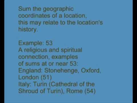
Geographic Coordinates Patterns, Coordinate Sums related to History and Revelation
Geographic coordinates of some locations, related to history and Book of Revelation passag...
published: 24 Dec 2009
Author: revelation13net
Geographic Coordinates Patterns, Coordinate Sums related to History and Revelation
Geographic coordinates of some locations, related to history and Book of Revelation passages. Refer to my web page:revelation13.net Copyright 2009 by T. Chase. From the Revelation13.net web site, also see Revelation13.net (Revelation 13: Prophecies of the Future, Astrology, Nostradamus, Bible Prophecy, the King James version English Bible Code).
12:21
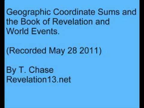
Geographic Coordinates Sums and the Book of Revelation and World Events
Summing the geographic coordinates of a location, relating to a Book of Revelation passage...
published: 29 May 2011
Author: revelation13net
Geographic Coordinates Sums and the Book of Revelation and World Events
Summing the geographic coordinates of a location, relating to a Book of Revelation passage. Intelligent design in the world based on Biblical passages. There appears to be patterns when lattitude and longitude are summed. For example, for Jerusalem, 31 deg. N, 35 deg. E, totaling 66 deg. 59 min. or approxmately 66-60 (666). We will look at some other location coordinate sums, relating these numbers to Book of Revelation passages and recent events. Note that 66-60 degree (or 67-00) (corresponding to 666) coordinate sum graph is a diagonal line stretching from 67 N, 0 E on the Arctic Circle between Norway and Greenland, to 67 E 0 N in the Indian Ocean. This 666 sum line passes exactly through Jerusalem, close to Bethlehem in Israel (66-55 sum), close to Berlin Germany (66-0 sum). New York City. 40 N + 74 W = 114 degrees sum. Revelation 11:4, King James version: " These are the two olive trees, and the two candlesticks standing before the God of the earth." (relate to the two world trade center towers being destroyed on September 11. Washington DC, 116 sum. Revelation 11:6: "These have power..." Los Angeles, 152 sum. Revelation 15: About the seven angels, and LA is the City of Angels. Yellowstone National Park, Wyoming. 156 sum. Revelation 15:6 is 7 angels with 7 plagues. This could relate to the danger of the Yellowstone supervolcano exploding and wiping out much of the life on earth. Moscow, Russia, 93 sum. Revelation 9:3: locusts come out of the bottomless pit: airplanes <b>...</b>
9:21
New Age geography: Patterns in Shapes: Countries and Geographic Coordinates
Copyright 2006 by T. Chase. New Age Geography: are there patterns to shapes of countries a...
published: 26 Aug 2006
Author: revelation13net
New Age geography: Patterns in Shapes: Countries and Geographic Coordinates
Copyright 2006 by T. Chase. New Age Geography: are there patterns to shapes of countries and geographical coordinates, lattitude and longitude, that indicate Intelligent Desin to this world? Coordinates are related to Comet Hale-Bopp and the King James Bible Book of Revelation. From the Revelation13.net web site, for more on this see Revelation13.net (Revelation 13: Prophecies of the Future, Astrology, Nostradamus, Bible Prophecy, the King James version English Bible Code).
14:21

ArcGIS - Introduction to Geographic Information Systems - Chapter 3 - Vector Data Model
Introduction to Geographic Information Systems, 5e is designed to provide students in a fi...
published: 03 Sep 2010
Author: jacketphish
ArcGIS - Introduction to Geographic Information Systems - Chapter 3 - Vector Data Model
Introduction to Geographic Information Systems, 5e is designed to provide students in a first or second GIS course with a solid foundation in both GIS concepts and the use of GIS. Introduction to GIS strikes a careful balance between GIS concepts and hands-on applications. The main portion of the chapter presents GIS terms and concepts and helps students learn how each one fits into a complete GIS system. At the end of each chapter, an application section with 2-7 tasks presents students with actual GIS exercises and the necessary data to solve the problem. Key features This edition has combined georelational and object-based vector data models into one chapter. A couple of years ago the majority of GIS users were still using georelational vector data such as shapefiles. But now many have turned to object-based vector data such as the geodatabase. Therefore it makes sense to combine these two data models into a chapter and simply call the chapter vector data model. New and updated information on: Joins, relates, and relationship classes (Chapter 8) Cartographic representation (Chapter 9) Point pattern analysis (Chapter 11) Viewshed analysis (Chapter 14) v Geocoding (Chapter 15) About the author Kang-tsung Chang Karl Chang is a professor at the University of Idaho. Table of contents 1 Introduction 2 Coordinate Systems 3 Vector Data Model 4 Raster Data Model 5 GIS Data Acquisition 6 Geometric Transformation 7 Spatial Data Editing 8 Attribute Data Management 9 Data Display <b>...</b>
8:36

ArcGIS - Introduction to Geographic Information Systems - Chapter 4 - Raster Data Model
Introduction to Geographic Information Systems, 5e is designed to provide students in a fi...
published: 06 Sep 2010
Author: jacketphish
ArcGIS - Introduction to Geographic Information Systems - Chapter 4 - Raster Data Model
Introduction to Geographic Information Systems, 5e is designed to provide students in a first or second GIS course with a solid foundation in both GIS concepts and the use of GIS. Introduction to GIS strikes a careful balance between GIS concepts and hands-on applications. The main portion of the chapter presents GIS terms and concepts and helps students learn how each one fits into a complete GIS system. At the end of each chapter, an application section with 2-7 tasks presents students with actual GIS exercises and the necessary data to solve the problem. Key features This edition has combined georelational and object-based vector data models into one chapter. A couple of years ago the majority of GIS users were still using georelational vector data such as shapefiles. But now many have turned to object-based vector data such as the geodatabase. Therefore it makes sense to combine these two data models into a chapter and simply call the chapter vector data model. New and updated information on: Joins, relates, and relationship classes (Chapter 8) Cartographic representation (Chapter 9) Point pattern analysis (Chapter 11) Viewshed analysis (Chapter 14) v Geocoding (Chapter 15) About the author Kang-tsung Chang Karl Chang is a professor at the University of Idaho. Table of contents 1 Introduction 2 Coordinate Systems 3 Vector Data Model 4 Raster Data Model 5 GIS Data Acquisition 6 Geometric Transformation 7 Spatial Data Editing 8 Attribute Data Management 9 Data Display <b>...</b>
Vimeo results:
1:17

Posted: Visualizing US expansion through post offices.
This is a visualization of US expansion in North America from 1700 to 1900, seen through c...
published: 06 Aug 2011
Author: Derek Watkins
Posted: Visualizing US expansion through post offices.
This is a visualization of US expansion in North America from 1700 to 1900, seen through changes in the spatial distribution of post offices.
Data from the USPS Postmaster Finder, with lat/long coordinates extracted from placenames through correlation with the USGS Geographic Names Information System.
Better in HD! Made with Processing. More at http://derekwatkins.wordpress.com/2011/08/06/posted/
Update: I've also uploaded an interactive version of this map at http://derekwatkins.wordpress.com/2011/09/25/posted_interactive/
6:41

Walking on country with spirits, Wugal Wugal, Australia
Located on the eastern shore of Australia’s tropical north, Shipton’s Flat is home to Mari...
published: 03 Nov 2008
Author: UNUChannel
Walking on country with spirits, Wugal Wugal, Australia
Located on the eastern shore of Australia’s tropical north, Shipton’s Flat is home to Marilyn, a Kuku Nyungkal Aboriginal woman, and her family.
She has been living here the ancestral way – far removed from the services and conveniences of modern life – as part of the sublime performance of nature.
Like her ancestors before her, Marilyn walks through the Nyungkal bubu, the Nyungkal’s country, acknowledging and conversing with the Spirit beings around her.
Featuring Marilyn Wallace
Director/Camera/Editor: Paul Bell
Producer: Citt Williams
Associate Producers: Marliyn Wallace and Bruce White
Graphics: David Jimenez
Sound Mixer: Tfer Newsome
Shot on location in Shipton's Flat, Far North Qld Australia
Duration 6:41 minutes
Developed and produced for United Nations University (UNU) by UNU Media Studio & Marilyn Wallace, in association with UNU-IAS Traditional knowledge Initiative and The Christensen Fund.
Further information for this film can be found at film’s website: http://ourworld.unu.edu/en/walking-on-country-with-spirits/
United Nations University has published this work under a Creative Commons license - share alike, attribution, no derivatives, non-commercial
*About this Project*
Collaboratively made with Indigenous storytellers, these videobriefs are told in local languages, respect Intellectual Property rights and provide storytellers with media training, resources and a fair media engagement model for future projects. The final videos played alongside other international climate change videos at a locally coordinated forum event, in April 2009’s Indigenous Peoples Climate Change Summit and later at a special screening at the National Museum of Denmark during the Copenhagen COP15 meeting.
*About the filmmakers*
Paul Bell- Director/Camera/Editor
Feral Films is a production company based in Broome specialising in documentary film making. We are also available for corporate needs and television commercials. Available as freelance camera, editor, director, and stills photographer.
Citt Williams- Co-director/Producer/Editor
Citt is a documentary filmmaker at the UNU Media Studio with over 12 years producing experience in broadcast media. Citt’s produced documentary films have been screened at festivals including Cannes (Yellow Fella), Sundance, Mumbai, Melbourne and by broadcasters including the Australian Broadcasting Corporation, Discovery and National Geographic. She has a Masters degree in documentary from the Australian Film Television and Radio School (Sydney) and a Business degree in Film and TV Production from QUT (Brisbane). Within UNU, her unit “Media Studio” (MS) has grounded expertise in online learning, interactive media and video production and in linking development issues with visual media and online content on social and environmental issues. Her role in the UNU-IAS Traditional Knowledge Initiative seeks to build greater understanding and facilitate awareness of traditional knowledge (TK) to inform action by Indigenous peoples, local communities and domestic and international policy makers. Key outputs include research activities, policy studies, capacity development and online learning and dissemination.
Marilyn Wallace
Marilyn Wallace, a land conservation coordinator from New Queensland, Australia and a member of the Kuku Nyungkal clan, said she and her band were given a new beginning after being granted autonomy over their homelands. She urged the official delegates to take the time to "stop, look, listen and learn". Wallace and 14 other forest rangers manage their homelands in collaboration with Australian resource officials. The team is in the process of conducting a biological inventory of their range, incorporating traditional knowledge with cutting edge GIS digital mapping systems. "We are preserving the wisdom of the elders with modern technology," she said, a reminder that native people are not just victims of climate change but key players in the protection and preservation of ecosystems.
United Nations University Media Studio
The UNU Media Studio was established in March 2003 and works in collaboration with a global network of partners to develop and share open educational resources. Through a small team based in Tokyo, the UNU promotes innovation in the building of interactive content and video documentaries that engage, entertain and educate. The core creative team is comprised of specialists in web and graphic design, documentary and multimedia production, as well as educational technology and instructional design. In developing projects, this team collaborates with subject matter experts from within the UNU, from other UN bodies and from partner universities. The UNU Media Studio also collaborates with independent professionals in the area of documentary production, web application development, web design and instructional design. mediastudio.unu.edu
United Nations University Institute of Advanced Studies - Traditional Knowledge Inititaive
4:00

GPS drawing Week_13 Top Vormstudie
Drawings based on personal geographical data of one week. The speed of movement determines...
published: 31 Mar 2009
Author: Rnul Interactive
GPS drawing Week_13 Top Vormstudie
Drawings based on personal geographical data of one week. The speed of movement determines size and colours of the lines and circles.
0:38

Geotagging with Trackstick
From Wikipedia: Geotagging, sometimes referred to as Geocoding, is the process of adding g...
published: 20 May 2008
Author: Telespial Systems
Geotagging with Trackstick
From Wikipedia: Geotagging, sometimes referred to as Geocoding, is the process of adding geographical identification metadata to various media such as websites, RSS feeds, or images and is a form of geospatial metadata. This data usually consists of latitude and longitude coordinates, though it can also include altitude, bearing, and place names.
Trackstick is a great tool for Geotaging all of your photos.
Youtube results:
9:23

C# Parallel Extensions : Pythagoras on geographic Cartesian coordinates
Ravi Puri Summer 2010...
published: 08 Jul 2010
Author: cornerserenader
C# Parallel Extensions : Pythagoras on geographic Cartesian coordinates
Ravi Puri Summer 2010
10:13

Geomapping 3 (a): different measuring systems, and centroids
Part 3 opens by looking at some bits and pieces I might have mentioned last time! Then we&...
published: 05 Aug 2012
Author: oldsynner
Geomapping 3 (a): different measuring systems, and centroids
Part 3 opens by looking at some bits and pieces I might have mentioned last time! Then we'll move onto the issue of the different coordinate systems that are common in GIS, and how to convert with them. Finally, we'll look at what centroids are, and how to prepare data on them for upload to ArcGIS. Convert Latitude-Longitude to Decimal: andrew.hedges.name-experiments-convert_lat_long- Wikipedia: Easting and northing: en.wikipedia.org-wiki-Easting_and_northing OS: Conversion of Eastings and Northings to Latitude and Longitude: www.ordnancesurvey.co.uk-oswebsite-freefun-geofacts-geo1188.html UK Grid Reference Finder, Batch Conversion Tool: gridreferencefinder.com-batchConvert-batchConvert.htm Centroid: en.wikipedia.org-wiki-Centroid OS: A guide to coordinate systems in Great Britain: www.ordnancesurvey.co.uk-oswebsite-gps-information-coordinatesystemsinfo-guidecontents-index.html
15:45

Reading UTM coordinates and entering them into a Garmin GPS
How to read UTM coordinates off of a map, reverse plot UTM coordinates, and also how to en...
published: 14 Jun 2011
Author: catdogs10
Reading UTM coordinates and entering them into a Garmin GPS
How to read UTM coordinates off of a map, reverse plot UTM coordinates, and also how to enter coordinates into a Garmin GPS.
2:37

Selecting the Position Format on the Garmin Etrex 30
Position Format, also know as the coordinate systems, show current and other locations on ...
published: 21 Oct 2011
Author: GPSCity
Selecting the Position Format on the Garmin Etrex 30
Position Format, also know as the coordinate systems, show current and other locations on a GPS map. Most common is the latitude longitude values. UTM are based off of the paper topo maps, and MGRS are made for military use. Manufacturer: Garmin Type: Outdoor GPS Model: 010-00970-20 UPC: 753759975906 Product info www.gpscity.ca www.gpscity.com Call Us 1-866-GPS-CITY (477-2489) Be Social with GPS City Facebook: www.facebook.com Twitter: twitter.com
 ( U.S. Fish and Wildlife monitor oil")


