Tue 2:00 pm EST
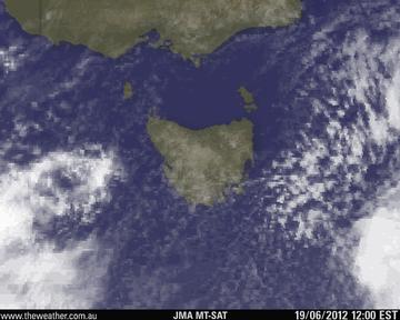
Cloud over TAS is thickening as a cold front impacts, causing showers to increase in the west and spread lightly east. It is becoming cold enough that snow is developing on the peaks. Snow should fall as low as 500 metres overnight, prompting bushwalking and road weather alerts.
Issued at 10:04AM on Tuesday 19 June 2012
Strong Wind Warning for E of Flinders Island, Upper/Lower E Coast,SE/SW Coast, Frederick Henry and Norfolk Bay and Storm Bay
Issued at 10:09AM on Tuesday 19 June 2012
Cancellation of Road Weather Alert for Western, Central Plateau and Upper Derwent Valley
HobartClearing shower |
5 - 12 |
LauncestonSunny |
1 - 12 |
| Tuesday | Wednesday | Thursday | Friday |
|---|---|---|---|
| Showers & highland snow clearing. Dry north coast. Strong, cold westerly winds easing. | Cold morning, fog patches. Cloud increasing. Stronger northwesterlies. Rain, mainly north, west. | Colder westerly change. Rain clearing from north. Showers elsewhere. | Fresh westerly winds across the state.. Rain in the west, showers elsewhere. |
| Minimum: | Mt Wellington, TAS | -3.0°C |
|---|---|---|
| Maximum: | Eddystone Pt, TAS | 12.5°C |
Tuesday: Southwesterly 15/20 knots decreasing to 10/15 knots during the afternoon then to 10 knots by early evening.<p>Wednesday: Northwesterly 5/10 knots increasing to 10/20 knots around dawn then tending north to northwesterly 20/30 knots during the afternoon. Sea: Up to 1.5 m Swell: Up to 1.0 m
Tuesday: Southwesterly 15/25 knots decreasing to 10/20 knots during the afternoon then tending west to southwesterly 10/15 knots by early evening. Winds becoming westerly to 10 knots later in the evening.<p>Wednesday: North to northwesterly 10/20 knots becoming northerly 20/25 knots during the morning then tending north to northwesterly 20/30 knots around midday. Sea: Up to 2.0 m Swell: Up to 1.0 m
Tuesday: South to southwesterly 10/20 knots tending westerly to 10 knots during the afternoon then north to northwesterly 5/15 knots by early evening. Winds becoming northerly 15/20 knots later in the evening.<p>Wednesday: Northerly 20/30 knots tending north to northwesterly 30/35 knots during the morning then west to northwesterly 25/30 knots by early evening. Winds becoming westerly 15/20 knots later in the evening. Sea: Up to 1.5 m Swell: Up to 4.0 m
Tuesday: Southwesterly 15/25 knots decreasing to 10/20 knots during the afternoon then tending west to southwesterly to 10 knots by early evening. Winds tending northwesterly to 10 knots later in the evening.<p>Wednesday: Northerly 5/15 knots tending north to northwesterly 10/20 knots during the morning. Sea: Up to 1.0 m
Tuesday: South to southwesterly 10/20 knots tending west to southwesterly to 10 knots during the afternoon then northwesterly 5/15 knots by early evening. Winds tending north to northwesterly 10/20 knots later in the evening.<p>Wednesday: Northerly 15/25 knots increasing to 20/30 knots around dawn then tending north to northwesterly 25/35 knots during the afternoon. Winds tending west to northwesterly 20/30 knots later in the evening. Sea: Up to 2.0 m Swell: Up to 4.0 m
Tuesday: Southwesterly 20/30 knots decreasing to 15/25 knots during the afternoon then tending west to southwesterly 10/15 knots by early evening. Winds tending west to northwesterly about 10 knots later in the evening.<p>Wednesday: Northerly 10/20 knots tending north to northwesterly 15/25 knots during the afternoon. Sea: Up to 3.0 m
Variable to 10 knots.
Tuesday: Southwesterly 20/30 knots decreasing to 15/25 knots by early evening then to 10/15 knots later in the evening.<p>Wednesday: Northwesterly 5/15 knots, reaching 20 knots at times, tending northerly 15/25 knots around dawn then increasing to 20/30 knots around midday. Sea: Up to 3.0 m Swell: Up to 4.0 m
Tuesday: Southwesterly 15/25 knots, reaching 30 knots at times, decreasing to 15/25 knots by early evening then to 10/15 knots later in the evening.<p>Wednesday: West to northwesterly 5/15 knots tending north to northwesterly 15/25 knots during the morning then increasing to 20/30 knots during the afternoon. Sea: Up to 3.0 m Swell: Up to 2.0 m
Tuesday: South to southwesterly 20/30 knots decreasing to 15/25 knots during the afternoon then becoming southwesterly 10/20 knots by early evening. Winds tending west to northwesterly to 10 knots later in the evening.<p>Wednesday: Northerly 10/20 knots increasing to 20/25 knots around dawn then tending north to northwesterly 20/30 knots around midday. Sea: Up to 3.0 m Swell: Up to 4.0 m
Tuesday: Southwesterly 15/25 knots, reaching 30 knots at times, decreasing to 10/15 knots during the afternoon then tending west to northwesterly by early evening. Winds tending northerly 10/20 knots later in the evening.<p>Wednesday: Northerly 20/30 knots tending north to northwesterly 25/35 knots during the morning then increasing to 30/40 knots by early evening. Winds tending westerly 20/30 knots later in the evening. Sea: Up to 3.0 m Swell: Up to 4.0 m
Tuesday: Southwesterly 20/30 knots decreasing to 10/20 knots during the evening.<p>Wednesday: West to northwesterly 5/15 knots tending north to northwesterly 15/20 knots around dawn then increasing to 20/25 knots during the morning. Winds increasing to north to northwesterly 25/30 knots around midday. Sea: Up to 3.0 m Swell: Up to 3.0 m

This service may include material from Agence France-Presse (AFP), APTN, Reuters, AAP, CNN and the BBC World Service which is copyright and cannot be reproduced.
AEST = Australian Eastern Standard Time which is 10 hours ahead of UTC (Greenwich Mean Time)