


![[Me]](/web/20111102054414im_/http://cotch.net/avatars/users/Joe.jpg "Me")


|
Wed, 26 Oct 2011 |
Haystacks Not a big hill by Lake District standards, but a popular one.  Because of its pleasant ascents past the tarns and rock formations.
And the view over Buttermere and the valley.  More on Wikipedia.  | ||||||||||
|
| |||||||||||
|
Wed, 3 Aug 2011 |
Flashride for Blackfriars In 2000, London's previous mayor, Ken Livingstone, began the process of fixing forty years of mistakes that had been made in the pursuit of the impossible -- the comfortable accommodation of mass motor vehicle use in a dense city centre. He recognised that cities are supposed to be places for people and returned key locations like Trafalgar Square to use as more than mere traffic gyratories.
But the current mayor has not quite caught up with the modern age and still labours under the delusion that congestion and the problems of the motor vehicle can be solved with bigger and faster roads.  While claiming to be the cycling mayor he tells us that a splash of blue paint along the gutter and through the bus stops is enough to fix the conditions that prevent most people from ever using their bicycles. 
And his officers at TfL push through these wider and faster roads in the name of, er, accommodating pedestrians (wider roads are good for pedestrians, right?). While ripping out the pedestrian crossings.  After ignoring the thousands of objections to the wider and faster road layout at Blackfriars, TfL announced last week that they were bring in the earth movers on Friday night. So with 48 hours notice we assembled a thousand cyclists for a go slow. 
It might be too late for Blackfriars this time around, but we still have a mayor who is stuck in 1970s, determined to force ever more motor vehicles through the centre of the city, at the expense of the sensible majority who combine walking, cycling, and public transport, and the vibrant city activity that depends on attracting people. It's not the last he's heard from us.  More at: http://cyclelondoncity.blogspot.com/ http://waronthemotorist.wordpress.com/tag/boris-johnson/ http://ibikelondon.blogspot.com/search/label/Boris%20Johnson http://cycleoffutility.wordpress.com/category/mayor-of-london/ | ||||||||||
|
| |||||||||||
|
Thu, 7 Apr 2011 |
The Moine House The geology and landscape of the Scottish Highlands are famously divided by the Great Glen fault. Less famous is the Moine Thrust Belt, running almost parallel to the Great Glen a hundred miles north. Here the rocks and landscape of the northern Highlands are pushed over those of the Hebrides and far north west, forming a belt of steep hills and cliffs from the north coast at Eriboll down to the west coast at Skye. It's named for The Moine -- the moss -- the vast peat moor that sits at the top of the hill on the northern Highland rocks above Eriboll on the northern coast of Sutherland.
As you climb the A838 from the sea inlets — from Loch Eriboll heading east, or from Kyle of Tongue heading west — the great flat empty moor stretches to the distant mountains, Ben Loyal in the east and Ben Hope in the west, interrupted only by two curious steep pyramids almost on the horizon. As you cross the bog they grow into the gable-end walls of a house, a perfectly ordinary little highland cottage isolated in the middle of the moor.  With two rooms, a porch, and a loft, Moine House was built with the road in 1830 as a half-way stop for travellers. Occupied by several generations of Mackays, up to ten people at a time, the house still acted as an inn for travellers throughout the 1800s, until the motorcar era negated its original purpose, and the Mackays moved on to less harsh and more profitable locations.
The roof fell in sometime around 1987, though there has been some attempt since to preserve what remains. The EU have since "improved" the A838 by building a whole new road over the moor on a different alignment, straighter, wider, faster, allowing the old single track road outside the house to slowly fade under the moss. Despite its isolated location, miles from anything in an already sparsely populated region without cities, it has managed to acquire some murals, distinctly urban in style, slightly faded now after three or four years exposed to the relentless rain of the northern Highlands.  More photos in the Highlands gallery. | ||||||||||
|
| |||||||||||
|
Sat, 5 Mar 2011 |
The Hutong At the start of the 15th century, when the Ming Dynasty was young, Beijing was established as the new Chinese capital — a heavily planned city, a rectangle laid out on a north-south axis around the great imperial palace, the Forbidden City.
Around the palace, dense blocks of residential buildings, the hutongs, arranged in a grid that stretched to the city walls and moat; the more prosperous and higher status families closer to the centre.  The hutongs evolved through dynasties, civil wars, and revolutions, declining as they became overcrowded and rundown. But they began to be truly threatened in the second half of the 20th century, when the grid of main streets was widened into great boulevards.
And the city walls and moat replaced by the Second Ring Road (there is no first ring road, but there is a third, and a fourth, and a fifth; the sixth is under construction and the seventh in planning stages), the hutong increasingly replaced by glass office towers and concrete apartment blocks.  The city's population boomed and as the economy grew its nascent middle class sprawled out far beyond the old city walls, and in the ancient centre, every accessible patch of ground was filled with a commuter's car -- there are five million of them in the city already, growing by 10% per year, or 1,500 extra cars every day.
In the run-up to the 2008 Olympics, the city invested in much regeneration — which often simply meant evicting residents of a hutong and bulldozing it.
But just as in Europe in the 1950s-70s, public opinion has quickly turned against this destruction of established neighbourhoods.  And now instead the remaining hutongs are being restored and gentrified as the city discovers a new way to exploit them in the burgeoning consumerist economy.
The Chinese have even noticed that the motorcar is not a sensible or scalable solution to transport in densely populated places, and is investing heavily in alternatives.  More photos in the Beijing gallery or this series of posts on the other blog. | ||||||||||
|
| |||||||||||
|
Tue, 1 Mar 2011 |
Brean Down A great limestone scarp runs the breadth of Somerset, the Mendip Hills, famous for their karst landscape — the gorge at Cheddar and the caves at Wookey Hole.
Where it meets the sea in the Bristol Channel, it takes the form of a 2km long peninsula beside the village of Brean, Brean Down, and 4km beyond that headland an island, Steep Holm.  Brean Down stands 98m above the surrounding flat farmland and wetlands of the Somerset Levels, with views south to Brent Knoll, north over Weston-super-Mare bay, out over the Bristol channel to Wales and inland along the Mendip scarp.
The Down was home to an iron-age hill fort and a Victorian coastal fort, later taken over for rocket and weapons research in the Second World War -- a large concrete arrow directed bombers to one of the test sites. View Larger Map These days its main claim to fame is as the site of the often-proposed-but-never-got-very-far Severn Barrage, which could in theory generate 5% of the UK's electricity.  But at the moment it's home only to a few people walking around the rocks and windswept rowans.
And a herd of National Trust goats.  Most of these were taken one day in february 2007. There are more photos under the Brean Down tag. | ||||||||||
|
| |||||||||||
|
Sat, 26 Feb 2011 |
Helmsdale Harbour In the winter, while I neglected to post on the blog, I spent some time out of the way to concentrate on work. Helmsdale in Sutherland was about as out of the way as I could find.
It's on the east coast in the far north of the Scottish Highlands, on the railway half way between Inverness and Thurso.  At the mouth of the Helmsdale River, otherwise known as River Ullie, which flows down the Strath of Kildonan (Strath Ullie) from Loch Badanloch.
It has a little harbour with big old breakwaters where the snow gathers and stays pristine until the stormy seas crash and overtop the walls.  Built in 1818 during the Highland clearances, when subsistence farmers were evicted by landlords who wanted to develop more profitable industries and agricultural practices on their estates.
The harbour was built to accommodate herring fleets, worked by the displaced farmers, and it was extended in 1823 and 1892, and refurbished in the last couple of years.  At one time the tiny port was home to 200 fishing boats, one of the largest herring fleets in Europe.
Now it's as much a tourist town as a fishing port, but a few boats remain, out every day, even in the darkest mid-winter.  More pictures in the Highlands gallery. | ||||||||||
|
| |||||||||||
|
Mon, 21 Feb 2011 |
Night bus A young smartly dressed woman gets on, concentrating on her phone call. The bus pulls out before she has time to mount the stairs, and the motion throws her to the side, her bag swinging and bashing the passenger behind her. Fifty. Nine. To. Streatham Hill. She climbs slowly, letting everybody know about the important things she has done today. Then drops into the nearest seat as the bus brakes at the first set of lights. "Did you remember to tape Eastenders?" Puts a laptop on one knee, opens Microsoft Excel, a page full of graphs. Continues call, continues describing her brilliant sucess with the Weight Watchers account. More passengers board, one indicates to the empty window seat beside her. She turns to let him through. Drops the computer. "Fucksake". People chuckle. 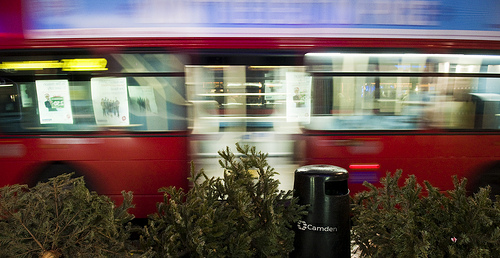 A young woman stumbles up the stairs at Shaftesbury Avenue. She's not dressed for the weather. Only a dress, earings, socks and a shock of hair. She carries only the mobile phone that she is jabbing at clumsily. She's crying, sniffing loudly. The bus is full, but everybody is silent. She sits on the top step and puts the phone to her ear. Nineteen. To. Battersea Bridge Road. "Daddy! -- Daddy come and get me." People stare out of the windows at the traffic. "I'm on a bus, but come and get me daddy. -- I've lost my shoes. -- I don't know. -- I'm on a bus I tried to get a taxi but I've lost my bag I'm so sorry daddy." She gets up and gets off at the next stop. A woman looks up from her knitting, turns to her partner and sighs. "Oh dear."  An old lady in a headscarf and heavy coat gets on at Trafalgar Square. Number. Twelve. To. Dulwich Library. She likes the bendy buses. Likes the big doors. On the double-deckers, she's always holding people up, her trolley bag always in somebody's way. On the number twelve, she's amongst recognisable faces from her neighbourhood. She sits down across from a young Iranian woman in a headscarf and heavy coat. The young woman's boy is playing on the bend in the bus, one foot on and one foot off the rotating section, surfing the corners. As the bus turns into Whitehall, a taxi cuts in front for a fare and the bus jerks to a stop. The boy tumbles, knocking the old woman's trolley bag over. A cauliflower rolls through the dirt under the seats. 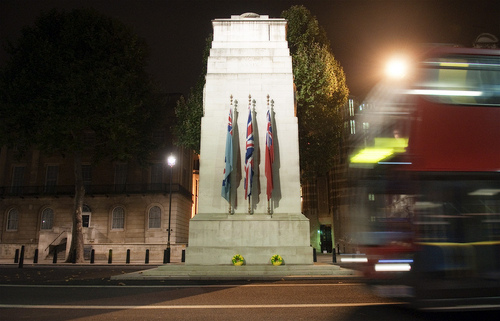 An elderly couple get on at the top end of Whitehall. In their eighties at least. She has thick NHS glasses and short dyed brown hair. He has thin grey hair and a thin grey face, but bright eyes still within it. He, a head taller than his wife. Walking stick in his left hand, with the other he briefly lets go of his wife's hand so that he can flash passes for the two of them. He surveys the bottom deck. Nobody is giving up their seats. But he seems happy to help his wife up the stairs to take the front seats -- she by the window, he by the aisle. The driver waits for them. Number. Three. To. Crystal Palace. "Number. Three," she repeats. "To. Crystal Palace. Crystal. Crystal Palace. Three." He pulls her tighter under his arm, his bright eyes dampening. Her bottom lip slumps and is still. He looks down on the wreaths of poppies outside, looks down on his Rosie, and remembers for her. 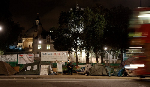 There is gridlock at the bottom end of Whitehall. The driver opens the doors to release those who would prefer to walk. Eighty. Eight. To. Clapham Common Old Town. The buses inch forwards on the single open southbound lane. On the northbound side, a pair of unmarked police cars have successfully blocked the progress of a black Range Rover. Behind them, a third and marked police car sits on top of the crumpled railings of the pedestrian crossing refuge, its remaining functioning lights still flashing. Bent over his car, a stoned man is having various items of clothing removed. A solitary protester from the peace camp dances alone in the empty street outside the foreign office. The traffic lights lying in the road turn green. The passengers have had their entertainment.  The river is the great border, the last of the bright lights. The red rippled reflections of the palace, parliament, and the red white and blue of the Eye, made to shimmer even more by the movement of the bus and the flow of a fast falling tide. The last of the crowds and movement, from the tourists stepping backwards into the bus lane to the bobbing boats below and the trucks and trains on the neighbouring bridges. And then, on the other side, dark empty streets under the railway arches and out into the suburbs. 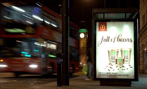 | ||||||||||
|
| |||||||||||
|
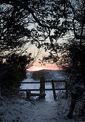
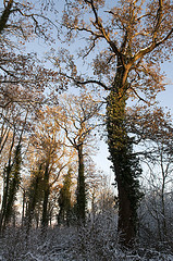
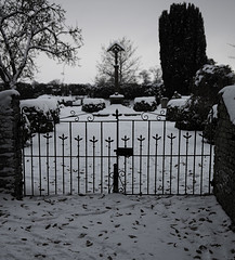
Wed, 16 Feb 2011 |
White Christmas At Christmas it snowed in Dorset. It doesn't often snow in Dorset. When it does, everyone gets out to use it while it lasts. 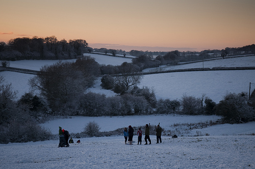 Goes sledging in the steep sheep fields.
Flattening the snow on the paths through the woods.
Leaving icy tracks on every slope.
Taking photos of the familiar landscape in a new outfit.
Before their feet trample it all down.          
 | ||||||||||
|
| |||||||||||
|
| |||
|


Browse... |
My other blog is a...
Follow them all here. |
Find me here... |
 All text and photography on this site is © Joe Dunckley 2001-10, except where stated otherwise. Text and photos are released under the terms of the Creative Commons BY-NC-SA license, meaning that you may reuse, remix, and republish the work for non-commercial purposes, on the condition that a credit is given to "Joe Dunckley/Cotch.net" and you make it clear that the work is released under this license. See this page for more detailed conditions. Contact me to enquire about commercial and editorial use.
0.36421918869019 secs